10°12′39″S36°50′24″W / 10.21083°S 36.84000°W
Contents

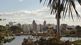
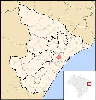
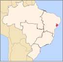
Propriá is a municipality located in the Brazilian state of Sergipe. Its population was 29,692 (2020) [1] and its area is 95 km². [2]
10°12′39″S36°50′24″W / 10.21083°S 36.84000°W
Propriá is a municipality located in the Brazilian state of Sergipe. Its population was 29,692 (2020) [1] and its area is 95 km². [2]
There are two football clubs in Propriá. América and Propriá. América owns José Neto Stadium, which has a maximum capacity of 3,000 people, and Propriá owns Constantino Tavares Stadium, which has a maximum capacity of 5,000 people. Also, both clubs plays at João Alves Filho Stadium, which has a maximum capacity of 3,000 people and is owned by Sergipe's state government.
Propriá is the seat of a Roman Catholic diocese, which covers 8,181 square kilometers (3,159 square miles), including the 95 square kilometers (36.67 square miles) of the municipality. The total population of the diocese is approximately 347,000 of which approximately 77% are Catholic. [3] The bishop is Vítor Agnaldo de Menezes [4]
| Climate data for Propriá (1991–2020) | |||||||||||||
|---|---|---|---|---|---|---|---|---|---|---|---|---|---|
| Month | Jan | Feb | Mar | Apr | May | Jun | Jul | Aug | Sep | Oct | Nov | Dec | Year |
| Mean daily maximum °C (°F) | 33.5 (92.3) | 33.5 (92.3) | 33.6 (92.5) | 32.3 (90.1) | 30.4 (86.7) | 28.9 (84.0) | 28.0 (82.4) | 28.3 (82.9) | 29.8 (85.6) | 31.7 (89.1) | 33.1 (91.6) | 33.7 (92.7) | 31.4 (88.5) |
| Daily mean °C (°F) | 27.7 (81.9) | 28.0 (82.4) | 28.0 (82.4) | 27.1 (80.8) | 25.9 (78.6) | 24.4 (75.9) | 23.6 (74.5) | 23.7 (74.7) | 24.6 (76.3) | 26.1 (79.0) | 27.2 (81.0) | 27.7 (81.9) | 26.2 (79.2) |
| Mean daily minimum °C (°F) | 23.1 (73.6) | 23.5 (74.3) | 23.7 (74.7) | 23.2 (73.8) | 22.4 (72.3) | 21.3 (70.3) | 20.5 (68.9) | 20.0 (68.0) | 20.5 (68.9) | 21.4 (70.5) | 22.3 (72.1) | 23.0 (73.4) | 22.1 (71.8) |
| Average precipitation mm (inches) | 53.0 (2.09) | 32.3 (1.27) | 57.8 (2.28) | 102.9 (4.05) | 166.5 (6.56) | 153.3 (6.04) | 141.6 (5.57) | 83.8 (3.30) | 54.4 (2.14) | 38.1 (1.50) | 19.8 (0.78) | 20.8 (0.82) | 924.3 (36.39) |
| Average precipitation days (≥ 1.0 mm) | 4.2 | 4.1 | 6.0 | 10.0 | 14.6 | 16.5 | 18.2 | 13.4 | 8.4 | 4.2 | 2.8 | 3.2 | 105.6 |
| Average relative humidity (%) | 69.6 | 70.6 | 71.5 | 75.7 | 81.4 | 83.7 | 83.8 | 81.7 | 78.1 | 73.1 | 70.2 | 68.8 | 75.7 |
| Average dew point °C (°F) | 22.1 (71.8) | 22.5 (72.5) | 22.8 (73.0) | 23.0 (73.4) | 22.9 (73.2) | 22.1 (71.8) | 21.3 (70.3) | 20.9 (69.6) | 21.2 (70.2) | 21.4 (70.5) | 21.7 (71.1) | 21.9 (71.4) | 22.0 (71.6) |
| Mean monthly sunshine hours | 214.9 | 202.9 | 215.7 | 193.2 | 173.1 | 152.6 | 154.1 | 169.8 | 160.4 | 180.3 | 200.7 | 220.6 | 2,238.3 |
| Source: NOAA [5] | |||||||||||||
The square kilometre is a multiple of the square metre, the SI unit of area or surface area.

Sergipe, officially State of Sergipe, is a state of Brazil. Located in the Northeast Region along the Atlantic coast of the country, Sergipe is the smallest state in Brazil by geographical area at 21,910 square kilometres (8,460 sq mi), larger only than the Federal District. Sergipe borders Bahia to the south and west and Alagoas to the north. Aracaju is the capital and the largest city in the state; the state is divided into 75 municipalities. The state has 1.1% of the Brazilian population and produces only 0.6% of the Brazilian GDP.

Caruaru is a Brazilian municipality in the state of Pernambuco. The most populous city in the interior of the state, Caruaru is located in the microzone of Agreste and because of its cultural importance, it is nicknamed Capital do Agreste, Princesinha do Agreste, and Capital of agreste.
São José do Rio Preto is a municipality in the state of São Paulo, Brazil. It is located in the northwestern region of the state, approximately 440 km (270 mi) from the city of São Paulo and 700 km (430 mi) from Brasília. With a population of 469,173 inhabitants as of the 2021 census, it is the 11th largest city in São Paulo and the 36th largest in Brazil.

Piracicaba is a city located in the Brazilian state of São Paulo. The population is 423,323 (2022) in an area of 1,378.07 km2. It is at an elevation of 547 m above sea level.

Leme is a municipality in the state of São Paulo in Brazil. The population is 104,346 in an area of 403 km². At the 2000 census, it had 80,757 residents, 40,830 of whom are men and 39,927 women. 65,885 residents are 10 years old or older, and of these, 59,991, or 91.1%, are literate. Leme officially became a town on August 29, 1895. The municipality is formed by the main district and also includes the rural neighborhoods Taquari, Taquari Ponte and Caju.

Serra Talhada is a city in the state of Pernambuco, Brazil. It is located at 07º59'31" South and 38º17'54" West, at an altitude of 429 metres. As of 2020, its estimated population by IBGE was 86,915 people. Its area is approximately 2980 km sq.

Camaçari is a city in Bahia, Brazil. It is located at 12°41′51″S38°19′27″W. It is part of the Salvador Metropolitan Region, being the industrial city of the metropolis. Camaçari covers 784.658 km2 (302.958 sq mi), and had an estimated population of 304,302 in 2020, with a population density of 310 per square kilometer. The municipality consists of three districts: Camaçari, Abrantes, and Monte Gordo.

Itabuna is a municipality in Bahia, Brazil. It is the 6th largest city in Bahia by population after Salvador, Feira de Santana, Camaçari, Vitória da Conquista, and Juazeiro. It had an estimated 214,123 residents in 2021. Itabuna covers a total area of 401 square kilometres (155 sq mi) and has a population density of 550 residents per square kilometer.

Cachoeira do Sul is a municipality in the state of Rio Grande do Sul, southernmost Brazil.

Areia Branca is a municipality located in the Brazilian state of Sergipe. Its population was 18,686 (2020) and it covers 148.13 km2 (57.19 sq mi). Areia Branca has a population density of 120 inhabitants per square kilometer. It is located 36 km (22 mi) from the state capital of Sergipe, Aracaju. The municipality contains part of the Serra de Itabaiana National Park.

Cedro de São João is a municipality located in the Brazilian state of Sergipe. Its population was 5,391 (2022) and its area is about 84 km². The municipality is the largest producer of carne-de-sol in Sergipe and stands out in cross-stitch embroidery.

Estância is a municipality located in the Brazilian state of Sergipe. Its population is 69,556 (2020). Estância covers 644.5 km2 (248.8 sq mi), and has a population density of 110 inhabitants per square kilometer. It is located 66 km (41 mi) from the state capital of Sergipe, Aracaju. The city is the seat of the Roman Catholic Diocese of Estância.
Maruim is a municipality located in the Brazilian state of Sergipe. Its population was 17,271 (2020) and covers 95.55 km2 (36.89 sq mi). Maruim has a population density of 180 inhabitants per square kilometer. It is located 30 km (19 mi) from the state capital of Sergipe, Aracaju. Maruim borders the municipalities of Laranjeiras, Rosário do Catete, and Santo Amaro das Brotas, all within the state of Sergipe.
Nossa Senhora da Glória is a municipality located in the Brazilian state of Sergipe. Its population was 37,324 (2020) and its area is 757.45 km2 (292.45 sq mi). It has a population density of 48 inhabitants per square kilometer. Nossa Senhora da Glória is located 126 km2 (49 sq mi) from the state capital of Sergipe, Aracaju.
Poço Verde is the westernmost municipality in the Brazilian state of Sergipe. Its population was 23,867 as of 2020 and its area is 431 square kilometers.

Umbaúba is a municipality located in the Brazilian state of Sergipe. Its population was 25,550 (2020). Umbaúba covers 118.86 km2 (45.89 sq mi) and has a population density of 210 inhabitants per square kilometer. The municipality is located 95 km (59 mi) from the state capital of Sergipe, Aracaju.

América Futebol Clube, usually known simply as América or as América-SE, América (SE) or América do Sergipe, is a Brazilian football club from Propriá, Sergipe state.

Ritápolis is a Brazilian municipality located in the state of Minas Gerais. The city belongs to the mesoregion of Campo das Vertentes and to the microregion of Sao Joao del Rei. In 2020, the estimated population was 4,562.
Esporte Clube Propriá, commonly known as Propriá, is a Brazilian football club based in Propriá, Sergipe state. They won the Campeonato Sergipano once.
Capital: Aracaju | |||||||||||||||
| Agreste Sergipano |
|  | |||||||||||||
| Leste Sergipano |
| ||||||||||||||
| Sertao Sergipano |
| ||||||||||||||
| | This Sergipe, Brazil location article is a stub. You can help Wikipedia by expanding it. |