
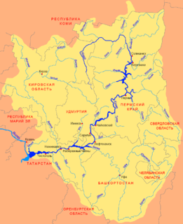
Ufa River is a river in the Urals, Chelyabinsk Oblast, Sverdlovsk Oblast, and the Republic of Bashkortostan; a tributary of the Belaya River. It is 918 kilometres (570 mi) long, and its basin covers 53,100 square kilometres (20,500 sq mi). It freezes up between late October and early December and stays under the ice until April or May. Pavlovka Hydroelectric Station is along the Ufa. The river's water is widely used for water supply. The main ports are Krasnoufimsk and Ufa.
The Kotuy River is a river in Krasnoyarsk Krai, Russia. It is one of the two rivers that form the Khatanga River; the other one being the Kheta River.

Nara River is a river in the Moscow Oblast and Kaluga Oblast in Russia. It is a left tributary of the Oka River. The length of the river is 158 kilometres (98 mi). The area of its basin is 2,030 square kilometres (780 sq mi). The Nara River freezes up in November–December and stays under the ice until April. The cities of Naro-Fominsk and Serpukhov are located on the Nara River.

The Nerl River is a river in Pereslavsky District of Yaroslavl and Kalyazinsky District of Tver Oblast in Russia, a right tributary of the Volga River. The length of the river is 112 kilometres (70 mi). The area of its drainage basin is 3,270 square kilometres (1,260 sq mi). Its main tributary is the Kubr River (left).

Bityug River is a river in Voronezh Oblast, Russia, a left tributary of the Don. Its upper reaches are located in Tambov Oblast. The Bityug is 379 kilometres (235 mi) long, with a basin of 8,840 square kilometres (3,410 sq mi). There are more than 400 lakes in the Bityug basin. The river freezes up in mid-December and stays icebound until late March or early April.
Zhizdra River is a river in Kaluga Oblast in Russia, Oka's left tributary. The length of the river is 223 kilometres (139 mi). The area of its basin is 9,170 square kilometres (3,540 sq mi). the Zhizdra River freezes up in late November and stays icebound until early April. Its main tributaries are the Resseta, Vytebet, and Serena. The towns of Kozelsk and Zhizdra are located on the shores of the Zhizdra. The name is of Baltic origin.

The Kema is a river in Vytegorsky and Vashkinsky Districts of Vologda Oblast in Russia. It flows out of Lake Kemskoye and is a tributary of Lake Beloye. It is 150 kilometres (93 mi) long, and the area of its basin 4,480 square kilometres (1,730 sq mi). The main tributary is the Indomanka River (left).
Pronya River is a river in Ryazan and Tula Oblasts in Russia, a right tributary of the Oka River. The length of the river is 336 kilometres (209 mi). The area of its basin is 10,200 square kilometres (3,900 sq mi). The river freezes up in late November and stays icebound until early March. The Pronya is navigable in its lower reaches. The town of Mikhailov is located on the Pronya River.
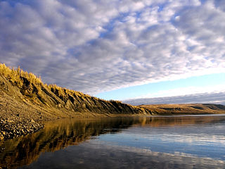
Kheta River is a river in Krasnoyarsk Krai in Russia, left composite of the Khatanga River. The river is 604 kilometres (375 mi) long. The area of its drainage basin is 100,000 square kilometres (39,000 sq mi). The Kheta is formed by the confluence of the Ayan and Ayakli Rivers, both of which originate in the Putoran plateau. The Kheta freezes up in late September or early October and breaks up in late May or the first half of June. Its main tributaries are the Boyarka, Maimecha, and Boganida Rivers.
The Luzha River, a river in Kaluga Oblast in Russia, originates in Moscow Oblast. It is a right tributary of the Protva River. The Luzha has a length of 159 km (99 mi) and a drainage basin area of 1,400 km2 (540 sq mi). The Luzha freezes up in November and breaks up in April. The town of Maloyaroslavets, the site of an important battle in 1812 during the French invasion of Russia, is located on the Luzha River.
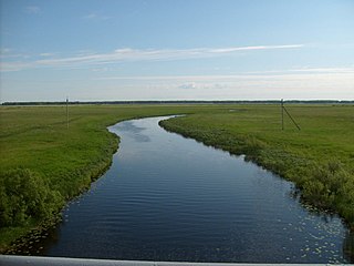
The Syun is a river in Bashkortostan and Tatarstan, Russian Federation, a left-bank tributary of the Belaya River. It is 209 kilometres (130 mi) long, of which 74 kilometres (46 mi) are in Tatarstan. Its drainage basin covers 4,500 square kilometres (1,700 sq mi).
Major tributaries in Tatarstan are Kalmiya, Sikiya, Terpelya, Bezyada, and Sharan in Bashkortostan. The maximal water discharge is 655 cubic metres per second (23,100 cu ft/s) (1979), and the maximal mineralization 500 to 1000 mg/l. Average sediment at the mouth per year is 120 millimetres (4.7 in). Drainage is regulated. Since 1978 it is protected as a "natural monument of Tatarstan".

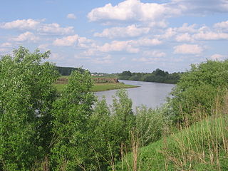
The Izh is a river in Udmurtia and Tatarstan, Russian Federation, a right-bank tributary of the Kama River. It is 226 kilometres (140 mi) long, of which 97 kilometres (60 mi) are in Tatarstan, and its drainage basin covers 8,478 square kilometres (3,273 sq mi). It begins near Malye Oshvortsy, Udmurtia and falls to the Nizhnekamsk Reservoir, Kama River, near Golyushurma tract in Agryzsky District, Tatarstan.
The Sheshma is a river in Tatarstan and Samara Oblast, Russian Federation, a left tributary of the Kama River, falling into the Kuybyshev Reservoir near Starosheshminsk. It is 259 kilometres (161 mi) long, of which 227 kilometres (141 mi) are in Tatarstan, and its drainage basin covers 6,040 square kilometres (2,330 sq mi).
The Sumka is a river in Zelenodolsky District of the Republic of Tatarstan, Russia, a left-bank tributary of the Volga River. It is 37 kilometres (23 mi) long, and its drainage basin covers 250 square kilometres (97 sq mi). It begins near Gremyachy Klyuch and flows to the Kuybyshev Reservoir, Volga, forming the western border of Vasilyevo, Tatarstan.
The Kargat is a river in Novosibirsk Oblast, Russia. It is a right tributary of the Chulym River. The Kargat is 387 kilometres (240 mi) in length, with a drainage basin of 7,200 square kilometres (2,800 sq mi)
Inya is a river in Kemerovo and Novosibirsk Oblasts of Russia. It is a right tributary of the Ob River. It is 663 kilometres (412 mi) long, with a drainage basin of 17,600 square kilometres (6,800 sq mi).
The Aktay or Aqtay is a river in Tatarstan, Russian Federation, a left-bank tributary of the Volga River, falling into the Kuybyshev Reservoir near Izmeri. It is 89 kilometres (55 mi) long, and its drainage basin covers 1,016 square kilometres (392 sq mi).
The Sit' River (Сить) is a tributary of the Rybinsk Reservoir. The river flows for 159 kilometres (99 mi) through Sonkovsky District of Tver Oblast and Nekouzsky and Breytovsky Districts of Yaroslavl Oblasts of Russia before entering the Rybinsk Reservoir near the large village of Breitovo. Its average width varies from 40 to 50 metres. The river mouth is about 1,500 metres (4,900 ft) wide. The drainage basin occupies some 1,900 square kilometres (730 sq mi). The river is 159 kilometres (99 mi) long.

Veslyana River – is a river in Perm Krai and Komi Republic, Russia, a left tributary of the Kama River, which in turn is a tributary of the Volga River.
It starts in the southeastern portion of Ust-Kulomsky District of the Komi Republic, about 7 kilometres (4 mi) from the border with Perm Krai. It flows through the Gaynsky District of Perm Krai and into the Kama River 1,193 kilometres (741 mi) from its mouth, 145 metres (476 ft) above sea level, near the rural locality of Ust-Veslyana.
The river is 266 kilometres (165 mi) long, and the area of its drainage basin is 7,490 square kilometres (2,890 sq mi).
Saba is a river in Leningrad Oblast, Russia, a left tributary of Luga River. It is 90 kilometres (56 mi) long. The area of its drainage basin is 1,320 square kilometres (510 sq mi). Its origin is southwestern portion of Krashogorskoye Lake. Main tributaries include:


