Providence Forge, Virginia

Last updated
The Providence Forge railroad depot is no longer in existence. Providence forge depot.jpg
The Providence Forge railroad depot is no longer in existence.

Providence Forge is an unincorporated community in New Kent County, Virginia, United States. It was one of the earliest settlements in the county (itself formed by 1654) and the site of a colonial iron forge that was destroyed by British General Banastre Tarleton during the American Revolutionary War.

Unincorporated area Region of land not governed by own local government

In law, an unincorporated area is a region of land that is not governed by a local municipal corporation; similarly an unincorporated community is a settlement that is not governed by its own local municipal corporation, but rather is administered as part of larger administrative divisions, such as a township, parish, borough, county, city, canton, state, province or country. Occasionally, municipalities dissolve or disincorporate, which may happen if they become fiscally insolvent, and services become the responsibility of a higher administration. Widespread unincorporated communities and areas are a distinguishing feature of the United States and Canada. In most other countries of the world, there are either no unincorporated areas at all, or these are very rare; typically remote, outlying, sparsely populated or uninhabited areas.

New Kent County, Virginia County in the United States

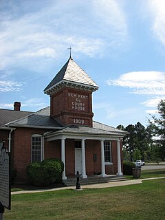
New Kent County is a county in the eastern part the Commonwealth of Virginia. As of the 2010 United States Census, the population was 18,429. Its county seat is New Kent.

Virginia State of the United States of America

Virginia, officially the Commonwealth of Virginia, is a state in the Southeastern and Mid-Atlantic regions of the United States located between the Atlantic Coast and the Appalachian Mountains. The geography and climate of the Commonwealth are shaped by the Blue Ridge Mountains and the Chesapeake Bay, which provide habitat for much of its flora and fauna. The capital of the Commonwealth is Richmond; Virginia Beach is the most populous city, and Fairfax County is the most populous political subdivision. The Commonwealth's estimated population as of 2018 is over 8.5 million.

Nearby, the Chickahominy River separates New Kent from Charles City County. U.S. Route 60 and State Route 155 pass through Providence Forge. The Colonial Downs horse-racing facility is located nearby adjacent to the Providence Forge exit of Interstate 64.

Chickahominy River river in the United States of America

The Chickahominy is an 87-mile-long (140 km) river in the eastern portion of the U.S. state of Virginia. The river, which serves as the eastern border of Charles City County, rises about 15 miles (24 km) northwest of Richmond and flows southeast and south to the James River. The river was named after the Chickahominy Indian tribe who lived near the river when it was claimed by English colonists in 1607. Chickahominy descendants live in Charles City County today.

Charles City County, Virginia County in the United States

Charles City County is a historic county located in the U.S. commonwealth of Virginia. The county is situated southeast of Richmond and west of Jamestown. It is bounded on the south by the James River and on the east by the Chickahominy River.

Colonial Downs

Colonial Downs is a racetrack located in New Kent County, Virginia adjacent to Interstate 64, halfway between Richmond and Williamsburg. The track conducted Thoroughbred flat racing and Standardbred harness racing between 1997 and 2014. It is owned by the Colonial Downs Group.

A station on the Chesapeake and Ohio Railway (C&O) was located at Providence Forge in 1881 during construction of the railroad's new Peninsula Subdivision, which was built primarily to facilitate transportation of West Virginia bituminous coal to the newly created city of Newport News. There, on the harbor of Hampton Roads, coal piers were built to load colliers for worldwide export shipment. [1]

Chesapeake and Ohio Railway defunct American Class I railway

The Chesapeake and Ohio Railway was a Class I railroad formed in 1869 in Virginia from several smaller Virginia railroads begun in the 19th century. Led by industrialist Collis P. Huntington, it reached from Virginia's capital city of Richmond to the Ohio River by 1873, where the railroad town of Huntington, West Virginia was named for him.

West Virginia State of the United States of America

West Virginia is a state located in the Appalachian region in the Southern United States that is also considered to be a part of the Middle Atlantic States. It is bordered by Pennsylvania to the north, Maryland to the east and northeast, Virginia to the southeast, Kentucky to the southwest, and Ohio to the northwest. West Virginia is the 41st largest state by area, and is ranked 38th in population. The capital and largest city is Charleston.

Bituminous coal collective term for higher quality coal

Bituminous coal or black coal is a relatively soft coal containing a tarlike substance called bitumen or asphalt. It is of higher quality than lignite coal but of poorer quality than anthracite. Formation is usually the result of high pressure being exerted on lignite. Its coloration can be black or sometimes dark brown; often there are well-defined bands of bright and dull material within the seams. These distinctive sequences, which are classified according to either "dull, bright-banded" or "bright, dull-banded", is how bituminous coals are stratigraphically identified.

The C&O's Peninsula Extension was good news for the farmers and merchants of the Virginia Peninsula, and they generally welcomed the railroad. Providence Forge was a stop for passengers until about 1931 and for freight until at least the late 1960s, according to the Chesapeake & Ohio Historical Society. The structure was dismantled sometime in 2006. The only similar structure, at Lee Hall, has been preserved and efforts were underway in 2008 to relocate it slightly away from the right-of-way and open it as a museum. [2]

Peninsula Extension

The Peninsula Extension which created the Peninsula Subdivision of the Chesapeake and Ohio Railway (C&O) was the new railroad line on the Virginia Peninsula from Richmond to southeastern Warwick County. Its principal purpose was to provide an important new pathway for coal mined in West Virginia to reach the harbor of Hampton Roads for coastal and export shipping on collier ships.

Virginia Peninsula

The Virginia Peninsula is a peninsula in southeast Virginia, USA, bounded by the York River, James River, Hampton Roads and Chesapeake Bay. It is sometimes known as the Lower Peninsula to distinguish it from two other peninsulas to the north, the Middle Peninsula and the Northern Neck.

Lee Hall, Virginia Neighborhood in Virginia, United States

Lee Hall is a former unincorporated town long located in the former Warwick County. Since 1958, Lee Hall has been a suburban community in the extreme western portion of the independent city of Newport News in the Commonwealth of Virginia.

Cedar Grove, Emmaus Baptist Church, Olivet Presbyterian Church, and Spring Hill are listed on the National Register of Historic Places. [3]

Cedar Grove (Providence Forge, Virginia) human settlement in Virginia, United States of America

Cedar Grove is a historic plantation house located near Providence Forge, New Kent County, Virginia. The main section was built about 1810, and is a 2 1/2-story, single pile, brick structure. The frame section was added about 1916. It has a traditional one-room side-hall plan. Also on the property are a contributing smokehouse and several sheds added about 1916. It was the farm residence of the Christians, a leading county family of colonial and early-Republican times. The 19th-century cemetery contains the graves of the Christian family, including Letitia Christian Tyler, the first wife of President John Tyler.

Emmaus Baptist Church church building in Virginia, United States of America

Emmaus Baptist Church is a historic Southern Baptist church located near Providence Forge, New Kent County, Virginia. It was built between 1849 and 1852, and is a rectangular, simple nave- plan structure in the Greek Revival style. It measures 38 feet wide by 50 feet long. Also on the property is a contributing church cemetery that contains 195 tombstones with dates ranging from 1855 to 1989.

Olivet Presbyterian Church church building in Virginia, United States of America

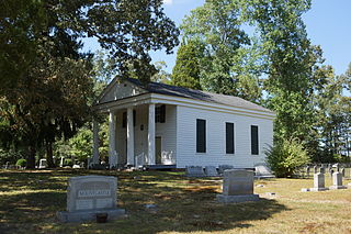
Olivet Presbyterian Church is a historic Presbyterian church located near Providence Forge, New Kent County, Virginia. It was built in 1856, and is a small frame church building in the Greek Revival style. It features a flush-boarded, pedimented portico with four fluted Greek Doric order columns.

Related Research Articles

Thurmond, West Virginia Town in West Virginia, United States

Thurmond is a town in Fayette County, West Virginia, United States, on the New River. The population was five at the 2010 census. During the heyday of coal mining in the New River Gorge, Thurmond was a prosperous town with a number of businesses and facilities for the Chesapeake and Ohio Railway. The town was the filming location for John Sayles' 1987 movie Matewan since it still possesses many of the characteristics of a 1920s Appalachian coal town.

Doswell, Virginia Unincorporated area

Doswell is an unincorporated community in Hanover County in the Central Region of the U.S. Commonwealth of Virginia. Originally called Hanover Junction, it was located on the Virginia Central Railroad, which later became part of the Chesapeake and Ohio Railroad (C&O) at a crossing of the Richmond, Fredericksburg and Potomac Railroad, a north-south route. Both railroads are now owned by CSX Transportation, although the former Virginia Central line is leased to a short-line carrier, Buckingham Branch Railroad. The area near the Doswell train station is a popular train-watching site for railfans.

Eastern Shore of Maryland region of the state of Maryland, United States of America

The Eastern Shore of Maryland is a part of the U.S. state of Maryland that lies predominantly on the east side of the Chesapeake Bay and consists of nine counties. As of the 2010 census, its population was 449,226, with just under 8 percent of Marylanders living in the region. The term "Eastern Shore" distinguishes a territorial part of the State of Maryland from the Western Shore of Maryland, land west of the Chesapeake Bay.

Virginia Central Railroad

The Virginia Central Railroad was an early railroad in the U.S. state of Virginia that operated between 1850 and 1868 from Richmond westward for 206 miles (332 km) to Covington. Chartered in 1836 as the Louisa Railroad by the Virginia General Assembly, the railroad began near the Richmond, Fredericksburg and Potomac Railroad's line and expanded westward to Orange County, reaching Gordonsville by 1840. In 1849, the Blue Ridge Railroad was chartered to construct a line over the Blue Ridge Mountains for the Louisa Railroad which reached the base of the Blue Ridge in 1852. After a decision from the U.S. Supreme Court, the Louisa Railroad was allowed to expand eastward from a point near Doswell to Richmond.

James River and Kanawha Canal canal in Virginia, United States of America

The James River and Kanawha Canal was a partially built canal in Virginia intended to facilitate shipments of passengers and freight by water between the western counties of Virginia and the coast. Ultimately its towpath became the roadbed for a rail line following the same course.

Western Maryland Railway defunct American Class I railway

The Western Maryland Railway was an American Class I railroad (1852–1983) which operated in Maryland, West Virginia, and Pennsylvania. It was primarily a coal hauling and freight railroad, with a small passenger train operation.

Norge is an unincorporated community in James City County, Virginia, United States.

Transportation in Virginia

Transportation in the Commonwealth of Virginia is by land, sea and air. Virginia's extensive network of highways and railroads were developed and built over a period almost 400 years, beginning almost immediately after the founding of Jamestown in 1607, and often incorporating old established trails of the Native Americans.

Toano, Virginia Unincorporated community in Virginia, United States

Toano, formerly Burnt Ordinary, is an unincorporated community in James City County, Virginia, United States.

Westham Station

Westham Station in Henrico County, Virginia, USA, was originally located at Westham on the Richmond and Allegheny Railroad (R&A), which was laid along the towpath of the James River and Kanawha Canal in the 1880s. The R&A railroad was acquired by the Chesapeake and Ohio Railway (C&O) in the 1890s. Westham Station was built in 1911, near the Westham Bridge, which spans James River. The station was heated by a coal stove and had a telegraph for communication through the 1950s.

Covington and Ohio Railroad

Covington and Ohio Railroad was part of a planned railroad link between eastern Virginia and the Ohio River in the 1850s. The mountainous region of the Allegheny Front of the Appalachian Plateau between an existing canal, railroads and navigable rivers represented a formidable obstacle.

Triple Crossing Richmond, Virginia, believed to be the only place in North America where three Class I railroads cross

Triple Crossing in Richmond, Virginia is believed to be the only place in North America where three Class I railroads cross at different levels at the same spot.

Williamsburg Transportation Center Railway station in Williamsburg, VA

Williamsburg Transportation Center is an intermodal transit station in Williamsburg, Virginia. Operated by Williamsburg Area Transit Authority, it is the central hub for local buses and also serves Amtrak's Northeast Regional train as well as Greyhound Lines and Hampton Roads Transit intercity buses.

East End (Richmond, Virginia)

The East End of Richmond, Virginia is the quadrant of the City of Richmond, Virginia, and more loosely the Richmond metropolitan area, east of the downtown.

Skiffes Creek

Skiffe's Creek is located in James City County and the independent city of Newport News in the Virginia Peninsula area of the Hampton Roads region of southeastern Virginia in the United States. It is a tributary of the James River.

Maidens, Virginia Unincorporated community in Virginia, United States

Maidens is a small unincorporated community in Goochland County, Virginia, United States. Sited on the north side of the James River, it is currently located on Maidens Rd. just south of the intersection of State Route 6.

References

  1. "Church Hill Tunnel". VT Underground. Archived from the original on 2006-05-30. Retrieved 2006-06-27.
  2. http://www.leehalldepot.org/
  3. National Park Service (2010-07-09). "National Register Information System". National Register of Historic Places . National Park Service.

Coordinates: 37°26′31″N77°02′37″W / 37.44194°N 77.04361°W / 37.44194; -77.04361

Geographic coordinate system Coordinate system

A geographic coordinate system is a coordinate system that enables every location on Earth to be specified by a set of numbers, letters or symbols. The coordinates are often chosen such that one of the numbers represents a vertical position and two or three of the numbers represent a horizontal position; alternatively, a geographic position may be expressed in a combined three-dimensional Cartesian vector. A common choice of coordinates is latitude, longitude and elevation. To specify a location on a plane requires a map projection.