Psedakh

Last updated

Psedakh
Пседах
Other transcription(s)
  IngushДолакоа [lower-alpha 1]
Location of Psedakh
Psedakh
Russia administrative location map.svg
Red pog.svg
Psedakh
Location of Psedakh
Outline Map of Ingushetia.svg
Red pog.svg
Psedakh
Psedakh (Republic of Ingushetia)
Coordinates: 43°28′06″N44°34′14″E / 43.46833°N 44.57056°E / 43.46833; 44.57056
Country Russia
Federal subject Ingushetia
Founded1820 [5]
Elevation
460 m (1,510 ft)
Population
  Total4,606
  Estimate 
(2021) [7]
6,066
  Subordinated to Malgobeksky District
Time zone UTC+3 (MSK   OOjs UI icon edit-ltr-progressive.svg [8] )
Postal code(s) [9]
386332
OKTMO ID26615410101

Psedakh [lower-alpha 2] is a rural locality (a selo ) in the Malgobeksky District of the Republic of Ingushetia, Russia. It forms the municipality of the rural settlement of Psedakh as the only settlement in its composition. [10] [11]

Contents

Etymology

Psedakh is a distorted version of the toponym, going back to the Kabardian Psydakhe (Kabardian : псы дахэ) which means "beautiful water/river". [12]

History

The village was founded in 1820 [5] on the territory of Little Kabardia  [ ru ]. The land was purchased from the Little Kabardian princes Bekovich-Cherkassky  [ ru ] and subsequently, in the 1860s, it was added to the Nazranian society. [13]

In 1926, the village was the center of the Achalukovsky District of the Ingush Autonomous Oblast and at the same time the center of the Psedakh village council which in addition to Psedakh, also included farms of Vostochny Sovetsky, Doholber, Zapadny Sovetsky, and Mazaevsky which arose in 1920–1921. In the village itself, there were 344 households (325 peasants and 19 non-peasant), and 1802 people lived (884 males and 918 females). [5]

Until 1944, the village was the administrative center of the Psedakhsky District of the Chechen-Ingush ASSR. In 1944, after the Deportation of the Chechens and Ingush and the abolition of the Chechen-Ingush Autonomous Soviet Socialist Republic, the village of Psedakh was renamed Alanskoe. [14] After the restoration of Chechen-Ingush autonomy in 1957, the settlement was returned to its former name – Psedakh.

Geography

The village of Psedakh on the map of the Ingush district in 1853. Ingushskii okrug na Dorozhnoi karte Kavkazskogo kraia 1853 g. (186(4).jpg
The village of Psedakh on the map of the Ingush district in 1853.
The village of Psedakh on the map of the Ingush district in 1869. Ingushskii okrug na karte Kavkazskogo kraia (1869 g.).jpg
The village of Psedakh on the map of the Ingush district in 1869.
The village Psedakh on the map of Sunzhensky (Ingush) otdel in 1892 Karta Terskoi Oblasti, 1892 g. (Sunzhenskii otdel).jpg
The village Psedakh on the map of Sunzhensky (Ingush) otdel in 1892

The village is located in the western part of the Malgobeksky District and is located south of the district center of the city of Malgobek, 35 km in a straight line northwest of the city of Magas, the capital of Ingushetia. In the northeast, the village of Sagopshi adjoins Psedakh, in the west – the village of Inarki, the nearest settlement in the southeast is Geyrbek-Yurt  [ ru ], in the southwest — Batako  [ ru ] (North Ossetia).

The settlement is located at the northern foot of the Sunzha Range  [ ru ], in the foothill zone. To the south of the village rises Mount Musakai (872.5 m), and to the southeast – Mount Babalo (818.1 m). Altitude fluctuations in the village are 420–540 meters above sea level. [15]

The hydrographic network is represented by the small river Psedakh, which originates on the northern slope of Mount Musakai and flows through the village. To the west of it, also on the northern slope of the Sunzha Range, the Zhoronka  [ ru ] river originates. [16]

The climate is moderately cold humid (Dfb). The amplitude of air temperature ranges from an average of +21.7°С in July to an average of −3.5°С in January. The average annual rainfall is 677 mm. The main amount of precipitation falls between April and August. [17]

Notes

  1. 1 2
     Commonly mentioned as 'Dolakoa' (Ingush: Долакоа), [1] [2] however the village was sometimes mentioned as 'Duola-Koa' (Ingush: Дуола-Коа) [3] or 'Dola-Koa' (Ingush: Дола-Коа). [4]
  2. Russian: Пседах; Ingush: Долакоа, romanized: Dolakoa; [lower-alpha 1] Chechen: Доьлака, romanized: Dölaka

    Related Research Articles

    <span class="mw-page-title-main">Nazran</span> Former capital city in Ingushetia, Russia

    Nazran is the largest city in Ingushetia, Russia. It served as the republic's capital from 1991 to 2000, until it was replaced by Magas, which was built for this purpose. It is the most populous city in the republic: 122,350 (2021 Census); 93,335 (2010 Russian census); 125,066 (2002 Census); 18,246 (1989 Soviet census).

    Sagopshi is a rural locality in Malgobeksky District of the Republic of Ingushetia, Russia. Population: 10,048 (2010 Russian census); 10,738 (2002 Census).

    Yalkharoy is a rural locality in Urus-Martanovsky District of the Republic of Chechnya, Russia. In the past the village Yalkharoy was part of the Gorsky section of the Ingush district.

    <span class="mw-page-title-main">Sunzha</span> Town in the Republic of Ingushetia, Russia

    Sunzha is a town and the administrative center of the Sunzhensky District of the Republic of Ingushetia, Russia. Before 2016 it was called Ordzhonikidzevskaya.

    <span class="mw-page-title-main">Malgobek</span> Town in the Republic of Ingushetia, Russia

    Malgobek is a town in the Republic of Ingushetia, Russia, located 45 kilometers (28 mi) northwest of the republic's capital of Magas. Population: 31,018 (2010 Russian census); 41,876 (2002 Census); 20,364 (1989 Soviet census).

    <span class="mw-page-title-main">Sunzhensky District, Republic of Ingushetia</span> District in Republic of Ingushetia, Russia

    Sunzhensky District is an administrative and municipal district (raion), one of the four in the Republic of Ingushetia, Russia. It is made up of territory that was formerly part of the Sunzha Cossack Okrug. It is located in the eastern and central parts of the republic. The area of the district is 1,513 square kilometers (584 sq mi). Its administrative center is the town of Sunzha. As of the 2010 Census, the total population of the district was 116,470, with the population of Sunzha accounting for 52.9% of that number.

    <span class="mw-page-title-main">Orstkhoy</span> Historical ethnoterritorial society among the Ingush and Chechen people

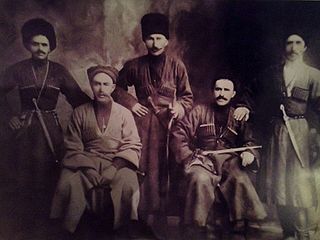
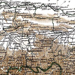
    The Orstkhoy, historically commonly known under their exonyms: Karabulaks, Balsu, Baloy, are a historical ethnoterritorial society among the Chechen and Ingush peoples. Their homeland is in the upper reaches of the Assa and Fortanga rivers in the historical region of Orstkhoy-Mokhk. In the tradition of the Chechen ethno-hierarchy, it is considered one of the nine historical Chechen tukkhums, in the Ingush tradition as one of the seven historical Ingush shahars.

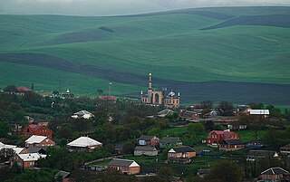
    Galashki is a rural locality in Sunzhensky District of the Republic of Ingushetia, Russia, located on the left bank of the Sunzha River near the border with the Republic of North Ossetia–Alania. Its population was about 9,000 people in 2009. Galashki forms the municipality of the rural settlement of Galashki as the only settlement in its composition.

    <span class="mw-page-title-main">Assinovskaya</span> Rural locality in Chechnya

    Assinovskaya is rural locality in Sernovodsky District of the Republic of Chechnya, Russia. In the past the village Assinovskaya was part of the Gorsky section of the Ingush district.

    Arshty is a rural locality in Sunzhensky District of the Republic of Ingushetia, Russia, located on left bank of the river Arshtynka near the border with the Republic of Chechnya. It forms the municipality of the rural settlement of Arshty as the only settlement in its composition.

    Muzhichi is a rural locality in Sunzhensky District of the Republic of Ingushetia, Russia, located on the left bank of the Sunzha River near the border with the Republic of North Ossetia–Alania. It forms the municipality of the rural settlement of Muzhichi as the only settlement in its composition.

    <span class="mw-page-title-main">Yandare</span> Rural locality in Ingushetia

    Yandare is a rural locality in Nazranovsky District of the Republic of Ingushetia, Russia. It forms the municipality of the rural settlement of Yandare as the only settlement in its composition.

    <span class="mw-page-title-main">Ekazhevo</span> Rural locality in Ingushetia

    Ekazhevo is a rural locality in Nazranovsky District of the Republic of Ingushetia, Russia. It forms the municipality of the rural settlement of Ekazhevo as the only settlement in its composition.

    <span class="mw-page-title-main">Barsuki, Ingushetia</span> Rural locality in Ingushetia

    Barsuki is a rural locality in Nazranovsky District of the Republic of Ingushetia, Russia. It forms the municipality of the rural settlement of Barsuki as the only settlement in its composition.

    <span class="mw-page-title-main">Plievo</span> Rural locality in Ingushetia

    Plievo is a rural locality in Nazranovsky District of the Republic of Ingushetia, Russia. It forms the municipality of the rural settlement of Plievo as the only settlement in its composition.

    <span class="mw-page-title-main">Surkhakhi</span> Rural locality in Ingushetia

    Surkhakhi is a rural locality in Nazranovsky District of the Republic of Ingushetia, Russia. It forms the municipality of the rural settlement of Surkhakhi as the only settlement in its composition.

    Dattykh is a rural locality in Sunzhensky District of the Republic of Ingushetia, Russia, located on the left bank of the river Fortanga. It forms the municipality of the rural settlement of Dattykh as the only settlement in its composition.

    <span class="mw-page-title-main">Fortanga</span> River in Ingushetia, Russia

    Fortanga historically sometimes referred as Balsu, is a river in North Caucasus that flows in Ingushetia and Chechnya. The length of the river is 69 km, the basin area is 526 km2.

    <span class="mw-page-title-main">Targim</span> Rural locality in Ingushetia

    Targim is an ancient city-settlement in the Dzheyrakhsky District of Ingushetia. It is part of the rural settlement of Guli. The entire territory of the settlement is included in the Dzheyrakh-Assa State Historical-Architectural and Natural Museum-Reserve and is under state protection.

    Gandalbos is rural locality in Sunzhensky District of the Republic of Ingushetia, Russia, located on the left bank of the river Fortanga. It is part of the municipality of the rural settlement of Dattykh.

    References

    1. Мальсагов 1963, p. 144.
    2. Оздоев 1980, p. 831.
    3. Барахоева, Кодзоев & Хайров 2016, p. 23.
    4. Кодзоев 2021, p. 446.
    5. 1 2 3 "Список населённых пунктов по Ингушской АО, составленный по материалам Всесоюзной переписи населения 1926 года". vivaldi.dspl.ru. p. 7.
    6. Russian Federal State Statistics Service (2011). Всероссийская перепись населения 2010 года. Том 1 [2010 All-Russian Population Census, vol. 1]. Всероссийская перепись населения 2010 года [2010 All-Russia Population Census] (in Russian). Federal State Statistics Service.
    7. "Таблица 5. Численность населения России, федеральных округов, субъектов Российской Федерации, городских округов, муниципальных районов, муниципальных округов, городских и сельских поселений, городских населенных пунктов, сельских населенных пунктов с населением 3000 человек и более". Всероссийской переписи населения 2020 года
    8. "Об исчислении времени". Официальный интернет-портал правовой информации (in Russian). June 3, 2011. Retrieved January 19, 2019.
    9. Почта России. Информационно-вычислительный центр ОАСУ РПО. (Russian Post). Поиск объектов почтовой связи (Postal Objects Search) (in Russian)
    10. "Закон Республики Ингушетия от 23 февраля 2009 года № 5-рз «Об установлении границ муниципальных образований Республики Ингушетия и наделении их статусом сельского поселения, муниципального района и городского округа»".
    11. "Поиск кодов ОКАТО. Сельское поселение Пседах, Малгобекский район". www.ocato.ru.
    12. Зязиков 2004, p. 82.
    13. Горная Летопись // Сборник сведений о кавказских горцах. Вып. II (in Russian). Тифлис: Типография Главного Управления Наместника Кавказского. 1869. p. 51.
    14. "В Президиум Верховного Совета РСФСР. Президиум Верховного Совета Северо-Осетинской АССР просит утвердить его постановление о переименовании населённых пунктов в новых районах, вошедших в состав Северо-Осетинской АССР…". www.ingusheti.ge.
    15. Лист карты K-38-18 Малгобек. Масштаб: 1 : 100 000. Состояние местности на 1983 год. Издание 1988 г.
    16. "Росреестр. Публичная кадастровая карта". pkk5.rosreestr.ru.
    17. "Климат Пседаха". ru.climate-data.org.

    Bibliography