Pskova River

Last updated

Coordinates: 57°49′31.12″N28°19′34.64″E / 57.8253111°N 28.3262889°E / 57.8253111; 28.3262889

Geographic coordinate system Coordinate system

A geographic coordinate system is a coordinate system that enables every location on Earth to be specified by a set of numbers, letters or symbols. The coordinates are often chosen such that one of the numbers represents a vertical position and two or three of the numbers represent a horizontal position; alternatively, a geographic position may be expressed in a combined three-dimensional Cartesian vector. A common choice of coordinates is latitude, longitude and elevation. To specify a location on a plane requires a map projection.

Pskova River
Ust'e reki Pskova.JPG

Kuznetskii most (Pskov).jpg

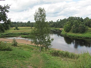
Kuznetsky Bridge over the Pskova River in Pskov
Country Russia
Physical characteristics
River mouth Velikaya River
Length 102 kilometres (63 mi) [1]
Basin features
Basin size 1,000 square kilometres (390 sq mi) [1]

The Pskova (Russian : Пскова) is a river in Strugo-Krasnensky and Pskovsky Districts of Pskov Oblast, as well as in the city of Pskov in Russia. It is a right tributary of the Velikaya River and belongs to the basin of the Narva River. It is 102 kilometres (63 mi) long, and the area of its basin 1,000 square kilometres (390 sq mi). The city of Pskov is located on the banks of the Pskova. The tributaries include: the Pskovitsa and the Drebyonka Rivers (left), as well as the Toroshinka and the Milyovka Rivers (right).

Russian language East Slavic language

Russian is an East Slavic language, which is official in the Russian Federation, Belarus, Kazakhstan and Kyrgyzstan, as well as being widely used throughout Eastern Europe, the Baltic states, the Caucasus and Central Asia. It was the de facto language of the Soviet Union until its dissolution on 25 December 1991. Although nearly three decades have passed since the breakup of the Soviet Union, Russian is used in official capacity or in public life in all the post-Soviet nation-states, as well as in Israel and Mongolia.

Strugo-Krasnensky District District in Pskov Oblast, Russia

Strugo-Krasnensky District is an administrative and municipal district (raion), one of the twenty-four in Pskov Oblast, Russia. It is located in the northeast of the oblast and borders with Plyussky District in the north, Shimsky and Soletsky Districts of Novgorod Oblast in the east, Porkhovsky District in the south, Pskovsky District in the west, and with Gdovsky District in the northwest. The area of the district is 3,090.1 square kilometers (1,193.1 sq mi). Its administrative center is the urban locality of Strugi Krasnye. Population: 13,466 (2010 Census); 16,579 ; 16,293 (1989 Census). The population of Strugi Krasnye accounts for 62.7% of the district's total population.

Pskovsky District District in Pskov Oblast, Russia

Pskovsky District is an administrative and municipal district (raion), one of the twenty-four in Pskov Oblast, Russia. It is located in the northwest of the oblast and borders with Gdovsky District in the north, Strugo-Krasnensky District in the northeast, Porkhovsky District in the east, Ostrovsky District in the south, and with Palkinsky and Pechorsky Districts in the southwest. Lake Peipus forms the border with Estonia in the west. The area of the district is 3,600 square kilometers (1,400 sq mi). Its administrative center is the city of Pskov. Population: 34,323 (2010 Census); 37,216 ; 37,557 (1989 Census).

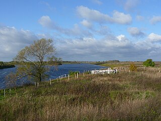
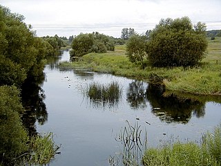
The source of the Pskova is in the western part of Strugo-Krasnensky District. The Pskova flows south, and a stretch of the river forms the border between Strugo-Krasnensky and Pskovsky Districts. The Pskova departs from the border back into Strugo-Krasnensky District, turns southwest and enters Pskovsky District. In the city of Pskov, it turns west and joins the Velikaya River. The Pskov Kremlin is located between by the mouth of the Pskova.

Pskov Krom

The Pskov Krom is an ancient citadel in Pskov, Russia. In the central part of the city, the Krom is located at the junction of the Velikaya River and smaller Pskova river. The citadel is of medieval origin, with the surrounding walls constructed starting in the late 15th century.

The drainage basin of the Pskova includes the eastern part of Pskovsky District and the southwestern part of Strugo-Krasnensky District.

Related Research Articles

Velikaya River river in Russia, a tributary of Lake Pskovskoe

The Velikaya is a river in Novosokolnichesky, Pustoshkinsky, Sebezhsky, Opochetsky, Pushkinogorsky, Ostrovsky, Palkinsky, and Pskovsky Districts of Pskov Oblast, as well as in the city of Pskov in Russia. It is a major tributary of Lake Peipus and belongs to the basin of the Narva River. It is 430 kilometres (270 mi) long, and the area of its basin 25,200 square kilometres (9,700 sq mi). The name of the river means literally "Grand" or "Great" in Russian. The towns of Opochka, Ostrov and Pskov are located on the banks of the Velikaya. The principal tributaries of the Velikaya are the Alolya River (right), the Issa River (left), the Sorot River (right), the Sinyaya River (left), the Utroya River (left), the Kukhva River (left), the Cheryokha River (right), and the Pskova River (right).

Shelon River river in Russia, tributary of Lake Ilmen

The Shelon is a river in the northwest part of European Russia, in Dedovichsky, Porkhovsky, and Dnovsky Districts of Pskov Oblast and Soletsky and Shimsky Districts of Novgorod Oblast. The Shelon is one of the principal tributaries of Lake Ilmen. It has a length of 248 kilometres (154 mi) and drains a basin of 9,710 square kilometres (3,750 sq mi). The towns of Porkhov and Soltsy, as well as urban-type settlements of Dedovichi and Shimsk, are located on the banks of the Shelon River. The principal tributaries of the Shelon are the Sudoma (left), the Belka (right), the Polonka (right), the Uza (left), the Udokha (left), the Sitnya (left), and the Mshaga (left).

Luga River river in Russia

The Luga River is a river in Novgorodsky and Batetsky Districts of Novgorod Oblast and Luzhsky, Volosovsky, Slantsevsky, and Kingiseppsky Districts of Leningrad Oblast of Russia. The river flows into the Luga Bay of the Gulf of Finland. It freezes up in the early December and stays under the ice until early April. The length of the Luga is 353 kilometres (219 mi), and the area of its drainage basin is 13,200 square kilometres (5,100 sq mi). Its main tributary is the Oredezh River (right). The towns of Luga and Kingisepp, as well as the urban-type settlement of Tolmachyovo are located on the banks of the Luga. The mouth of the Luga is the site of the Ust-Luga container terminal.

Kunya River river in Kunyinsky, Velikoluksky, and Loknyansky Districts of Pskov Oblast, Toropetsky District of Tver Oblast, and Kholmsky District of Novgorod Oblast in Russia

The Kunya is a river in Kunyinsky, Velikoluksky, and Loknyansky Districts of Pskov Oblast, Toropetsky District of Tver Oblast, and Kholmsky District of Novgorod Oblast in Russia. It is a major right tributary of the Lovat River. It is 258 kilometres (160 mi) long, and the area of its basin 5,143 square kilometres (1,986 sq mi). The town of Kholm is located in the mouth of the Kunya. The principal tributaries of the Kunya are the Oka, the Serezha, the Maly Tuder, and the Bolshoy Tuder.

Utroya River river

The Utroya is a river of Latvia and Pytalovsky and Ostrovsky Districts of Pskov Oblast of Russia, a left tributary of the Velikaya River. It is 176 kilometres (109 mi) long, and the area of its basin 3,000 square kilometres (1,200 sq mi). The principal tributary is the Lzha. The towns of Kārsava and Pytalovo are located on the banks of the Rītupe/Utroya.

Kukhva River river in Russia

The Kukhva is a river in Kārsava, Baltinava, and Viļaka municipalities of Latvia and in Pytalovsky and Ostrovsky Districts of Pskov Oblast in Russia. It is a left tributary of the Velikaya. It is 106 kilometres (66 mi) long, and the area of its basin 828 square kilometres (320 sq mi).

Strugi Krasnye Work settlement in Pskov Oblast, Russia

Strugi Krasnye is an urban locality and the administrative center of Strugo-Krasnensky District of Pskov Oblast, Russia, located 87 kilometers (54 mi) northeast of Pskov. Municipally, it is incorporated as Strugi Krasnye Urban Settlement, the only urban settlement in the district. Population: 8,447 (2010 Census); 8,762 (2002 Census); 7,067 (1989 Census).

Sinyaya River river

The Sinyaya is a river in Verkhnyadzvinsk Raion of Vitebsk Region of Belarus, in Zilupe, Ludza, and Cibla municipalities of Latvia, and in Sebezhsky, Krasnogorodsky, and Ostrovsky Districts of Pskov Oblast in Russia, part of the Baltic Sea basin. It is a left tributary of the Velikaya River. It is 195 kilometres (121 mi) long, and the area of its basin 2,040 square kilometres (790 sq mi).

Ostrovsky District, Pskov Oblast District in Pskov Oblast, Russia

Ostrovsky District is an administrative and municipal district (raion), one of the twenty-four in Pskov Oblast, Russia. It is located in the west of the oblast and borders with Pskovsky District in the north, Porkhovsky District in the northeast, Novorzhevsky District in the southeast, Pushkinogorsky and Krasnogorodsky Districts in the south, Pytalovsky District in the west, and with Palkinsky District in the northwest. The area of the district is 2,400 square kilometers (930 sq mi). Its administrative center is the town of Ostrov. Population: 31,096 (2010 Census); 36,685 ; 14,199 (1989 Census). The population of Ostrov accounts for 69.7% of the district's total population.

Porkhovsky District is an administrative and municipal district (raion), one of the twenty-four in Pskov Oblast, Russia. It is located in the central and northeastern parts of the oblast and borders with Strugo-Krasnensky District in the north, Soletsky District of Novgorod Oblast in the northeast, Dnovsky District in the east, Dedovichsky District in the southeast, Novorzhevsky District in the south, Ostrovsky District in the southwest, and with Pskovsky District in the west. The area of the district is 3,190 square kilometers (1,230 sq mi). Its administrative center is the town of Porkhov. Population: 21,568 (2010 Census); 28,470 ; 35,015 (1989 Census). The population of Porkhov accounts for 49.2% of the district's total population.

Zhelcha River river in Russia

The Zhelcha River is a river in Strugo-Krasnensky and Gdovsky Districts in Pskov Oblast, Russia, a tributary of Lake Peipus. It is 107 kilometres (66 mi) long, and the area of its drainage basin is 1,220 square kilometres (470 sq mi). It is navigable downstream from the settlement of Yamm. The main tributaries of the Zhelcha are the Dubenka, the Krapivenka, the Nizhnyaya Belka, and the Yeglina Rivers.

Podborovye is the name of several rural localities in Russia:

Cheryokha River river in Russia

The Cheryokha is a river in Ostrovsky, Porkhovsky, and Pskovsky Districts, and in the city of Pskov of Pskov Oblast in Russia. It is a right tributary of the Velikaya River and belongs to the basin of the Narva River. It is 145 kilometres (90 mi) long, and the area of its basin 3,230 square kilometres (1,250 sq mi). The main tributary is the Keb River (right).

The Sorot is a river in Novorzhevsky, Bezhanitsky, and Pushkinogorsky Districts of Pskov Oblast in Russia. It is a right tributary of the Velikaya River. It is 80 kilometres (50 mi) long, and the area of its basin 3,910 square kilometres (1,510 sq mi). The main tributary of the Sorot is the Lsta (left).

Alolya River river in Russia

The Alolya is a river in Opochetsky, Novorzhevsky, Bezhanitsky, and Pustoshkinsky Districts of Pskov Oblast in Russia. It is a right tributary of the Velikaya River. It is 105 kilometres (65 mi) long, and the area of its basin 860 square kilometres (330 sq mi).

Usvyacha River river in Belarus

The Usvyacha is a river in Kunyinsky and Usvyatsky Districts of Pskov Oblast in Russia and in Vitebsk Raion of Vitebsk Region in Belarus. It is a right tributary of the Daugava River. It is 100 kilometres (62 mi) long, and the area of its basin 2,340 square kilometres (900 sq mi).

Zamoshye is the name of several rural localities in Russia.

References

  1. 1 2 Река Пскова (in Russian). State Water Register of Russia. Retrieved 5 June 2012.