Myawaddy Township is a township of Myawaddy District in the Kayin State of Burma (Myanmar). It is the only township in Myawaddy District. The administrative seat is the town of Myawaddy.

Kyainseikgyi Township is a township of Kawkareik District in the Kayin State of Myanmar. It is the fourth-biggest township in Kayin State. The two main sub-towns are Kyeikdon and Payathonsu. It is drained by the Zami, Winyaw and the Haungtharaw rivers.
Payathonzu (Eastern Pwo: ကၠံင်သိုင့်ဖၠုံးဍုံ; Burmese: ဘုရားသုံးဆူမြို့ is a town in the Karen State of south Myanmar, close to the border with Thailand. Separated from the Thai border township of Nong Lu by the Three Pagodas Pass. It is also the administrative seat of Hpayarthonezu Sub-township in Kyain Seikgyi Township, Kawkareik District of Kayin State in Myanmar.
Kanni is a village in Kyain Seikgyi Township, Kawkareik District, in the Kayin State of Myanmar. It is located on the Zami River.
Kanni is a large village in Kawkareik Township of northern Kyain Seikgyi Township, Kawkareik District, in the Kayin State of Myanmar. It lies on the left (western) bank of the Haungtharaw (Haungthayaw) River just upstream (south) of where it flows into the Gyaing River.
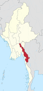
Kayin State, the name given by the Burmese military government to Karen State, is a state of Myanmar. The capital city is Hpa-An, also spelled Pa-An.

Peinnegon is a village in Kyain Seikgyi Township, Kawkareik District, in the Kayin State of Myanmar. It is located approximately 3 kilometres north-east of Kyeikdon.
Peinnegon is a village in Kyain Seikgyi Township, Kawkareik District, in the Kayin State of Myanmar. It lies on the foothills of the Dawna Range.
Peinnegon is a village in Kyain Seikgyi Township, Kawkareik District, in the Kayin State of Myanmar. It is on the foothills of the Dawna Range.
Akalaw is a village in Kyain Seikgyi Township, Kawkareik District, in the Kayin State of Myanmar. It is near the convergence of the Winyaw and Zami Rivers.
Ywathit is a village in Kyain Seikgyi Township, Kawkareik District, in the Kayin State of Myanmar. It is located on the eastern bank of the Winyaw River.

Kyondoe is a town located within the Kawkareik District of Kayin State, Myanmar. It is located on the India–Myanmar–Thailand Trilateral Highway and eastern bank of Haungtharaw River.

Kale is a large village in Kyain Seikgyi Township, Kawkareik District, in the Kayin State of Myanmar. According to 2014 Myanmar Census, the total population in Kale is 5,355. The Kha Lel village tract contains 5 villages and in 2014, it had a total population of 8,869 people.
Lutshan is a village in Kyain Seikgyi Township, Kawkareik District, in the Kayin State of Myanmar.

Taungdi Eastern Pwo: တံင့်တီႋ; Burmese: တောင်ဒီး [tàʊɴ Dí]) is a large village in Kyain Seikgyi Township, Kawkareik District, in the Kayin State of Myanmar.

Kyongawon is a village in Kyain Seikgyi Township, Kawkareik District, in the Kayin State of Myanmar. It lies on the Kyungawon Chaung, which runs from west to east through the village.
Putaw is a village in Kyain Seikgyi Township, Kawkareik District, in the Kayin State of Myanmar.
Let Hpaw or Retpu is a village, village tract of Hlut Shan (Lutshan) in Kyain Seikgyi Township, Kawkareik District, Kayin State, Myanmar (Burma). It lies on the alongside of Thailand–Burma Railway.
Myo Aung is a Burmese politician and medical doctor, currently serves as an Amyotha Hluttaw MP for Kayin State No. 9 constituency. He is a member of National League for Democracy.
Nan Thuzar Win is a Burmese politician who currently serves as a deputy speaker of Kayin State Hluttaw and a member of parliament in the Kayin State Hluttaw for Kawkareik Township № 1 Constituency. She is a member of the National League for Democracy.


