Llanito or Yanito is a form of Spanish heavily laced with words from English and other languages, such as Ligurian; it is spoken in the British overseas territory of Gibraltar. It is commonly marked by a great deal of code switching between Andalusian Spanish and British English and by the use of anglicisms and loanwords from other Mediterranean languages and dialects.

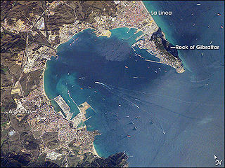
La Línea de la Concepción is a town in Spain, in the province of Cádiz in Andalucia. It lies on the eastern isthmus of the Bay of Gibraltar, north of the Gibraltar–Spain border, which lies north of the British overseas territory of Gibraltar, with which it has close economic and social links. It is situated on the sandy isthmus which unites the Rock of Gibraltar with the coast in the eastern flank of the Bay of Gibraltar, between Sierra Carbonera and the Rock of Gibraltar.
Los Barrios is a small town and municipality in the south of Spain. It is part of the province of Cádiz, which in turn is part of the Andalusia region. It belongs to the Campo de Gibraltar comarca. The town's name means “the districts” or “the neighbourhoods” in English.
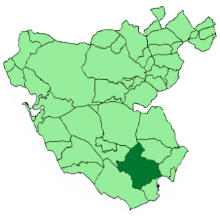
Campo de Gibraltar is a comarca (county) in the province of Cádiz, Spain, in the southwestern part of the autonomous community of Andalusia, the southernmost part of mainland Europe. It comprises the municipalities of Algeciras, La Línea de la Concepción, San Roque, Los Barrios, Castellar de la Frontera, Jimena de la Frontera and Tarifa.

La Alcaidesa is a gated community near Sotogrande, Spain, in the Andalusian province of Cádiz, accessed by junction 124 on the Autovía A-7 coastal motorway. The natural topography allows the town to enjoy an enviable location overlooking the Mediterranean with easy access to Gibraltar, the Campo and the towns of Algeciras and Marbella. The town has two manned, gated access points and mobile security patrols. A fire station exclusively serving Alcaidesa was built in 2008. The town boasts two golf courses, the original is links style, said to be the only one in Spain. The second is a more traditional heathland course. The popular beach called Playa de La Alcaidesa is linked to Playa de La Hacienda, looking towards La Linea it is possible to see Gibraltar.

Palmones is a village on the Bay of Gibraltar between Algeciras and La Linea de la Concepcion in the Province of Cádiz in Spain. The San Roque Refinery and Los Barrios commercial centre lie on either side of the town.

San Roque station is located in a neighbourhood belonging to the municipality of San Roque in the Cadiz province. The population of the neighbourhood is 2,582 inhabitants and it is situated between the river and the Guadarranque mountain. This neighbourhood is bordered by Taraguilla.

La Línea de la Concepción Bus Station is a bus station serving the Spanish municipality of La Línea de la Concepción in the Andalusian Province of Cádiz. It is the terminal of the regular services of buses in this city and is managed by the company CTSA-Portillo.
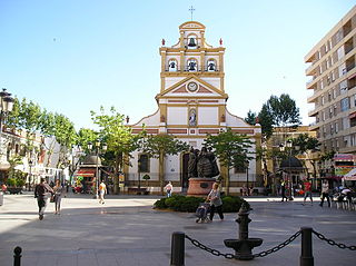
Iglesia de la Inmaculada Concepción is a parish church in the town of La Línea de la Concepción, in Andalusia, Spain.
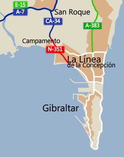
The Autovía CA-34 is an autovía in the province of Cádiz, Andalusia, Spain, providing a link between the Autovía A-7 and Gibraltar. It runs for 3 km between the A-7 at San Roque and the village of Campamento. Thereafter, it continues for a further 4 km as a national road, the N-351, through Campamento and along the west side of La Línea de la Concepción to the checkpoint at the border with Gibraltar. Once pass checkpoint vehicles enter Gibraltar onto Winston Churchill Avenue.

The Lines of Contravallation of Gibraltar, known in English as the "Spanish Lines", were a set of fortifications built by the Spanish across the northern part of the isthmus linking Spain with Gibraltar. They later gave their name to the Spanish town of La Línea de la Concepción. The Lines were constructed after 1730 to establish a defensive barrier across the peninsula, with the aim of preventing any British incursions, and to serve as a base for fresh Spanish attempts to retake Gibraltar. They played an important role in the Great Siege of Gibraltar between 1779 and 1783 when they supported the unsuccessful French and Spanish assault on the British-held fortress. The siege was ended after the lines of contravallation were attacked by British and Dutch forces under the command of the Governor of Gibraltar,General Augustus Eliot. The attack caused the Spanish forces to retreat and abandon the fortifications and the combined British led forces virtually destroyed all the spanish gun batteries and the enemy cannon and munitions either captured or destroyed. This attack is still commemorated to this day and is known as 'Sortie Day'.

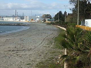
The Gibraltar-San Roque Refinery is an oil refinery owned by CEPSA located on the north shore of the Bay of Gibraltar, in Guadarranque Industrial Estate, between Puente Mayorga and the Guadarranque river, in the municipality of San Roque, Cadiz, Spain. It is located next to the Los Barrios Power Plant, which is a coal fueled power station.
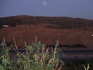
The Sierra Carbonera is a small range of mountains located in the Province of Cádiz in Spain, at the boundary between the municipalities of San Roque and La Línea de la Concepción, north of the Rock of Gibraltar. It rises to a maximum altitude of ==311 metres (1,020 ft) at the summit of Carboneras, which is occupied by a radio communications installation.
The Algeciras Gibraltar Railway Company was created by British businessmen to build the Algeciras-Bobadilla railway line between Algeciras and Bobadilla, Antequera, the first section of track was laid on 1 September 1888. The first train was purchased from Beyer, Peacock and Company in Manchester. A first class return ticket from Gibraltar to Ronda was set at 17.10 pesetas.
The San Roque-La Línea railway line is a railway line built by the Algeciras Gibraltar Railway Company, it connects La Línea de la Concepción to San Roque station, but that has never been used.
Campamento is a coastal village and district of the municipality of San Roque of the Province of Cádiz, Andalucia, Spain. Although it belongs administratively to San Roque, it is four kilometres south of the centre and is located on the Bay of Algeciras, to the northwest of Gibraltar, and is effectively a northwestern suburb of La Línea de la Concepción. As of 2011 it had 1836 inhabitants.