| Puerto Cisnes Airport | |||||||||||
|---|---|---|---|---|---|---|---|---|---|---|---|
| Summary | |||||||||||
| Airport type | Public | ||||||||||
| Serves | Puerto Cisnes | ||||||||||
| Elevation AMSL | 45 ft / 14 m | ||||||||||
| Coordinates | 44°45′30″S72°41′55″W / 44.75833°S 72.69861°W Coordinates: 44°45′30″S72°41′55″W / 44.75833°S 72.69861°W | ||||||||||
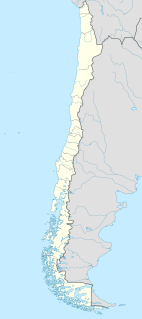
| Map | |||||||||||
 SCPK Location of Puerto Cisnes Airport in Chile | |||||||||||
| Runways | |||||||||||
| |||||||||||
Puerto Cisnes Airport( ICAO : SCPK) is an airport serving Puerto Cisnes, a port town on the Puyuhuapi Channel in the Aysén Region of Chile.

The ICAOairport code or location indicator is a four-letter code designating aerodromes around the world. These codes, as defined by the International Civil Aviation Organization and published in ICAO Document 7910: Location Indicators, are used by air traffic control and airline operations such as flight planning.
Puerto Cisnes is a town and seaport in Cisnes commune, Aysén Province, Aysén del General Carlos Ibáñez del Campo Region in the Chilean Patagonia. The town is on the Puyuhuapi Channel at the outflow of Cisnes River. The town is located in the northwestern portion of the Aysén Region, an area that includes numerous islands, fjords and channels. The major island is Magdalena Island, which contains the national park that bears its name. Queulat National Park straddles the border between this commune and Lago Verde. Much of the commune area is covered with a lush vegetation and is divided by the Moraleda Channel. The main mountain of the area is Melimoyu volcano.

Puyuhuapi, also Cai Channel is a sea channel separating Magdalena Island from the mainland of Aysén del General Carlos Ibáñez del Campo Region in Chile. The channel runs through a branch of the Liquiñe-Ofqui Fault. The main settlement in the channel is Puerto Cisnes.
Contents
The airport is in the delta of the Cisnes River, 3 kilometres (1.9 mi) southwest of the town. There are hills northeast and southwest of the runway.
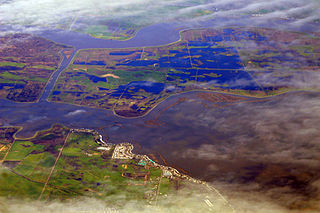
A river delta is a landform created by deposition of sediment that is carried by a river as the flow leaves its mouth and enters slower-moving or stagnant water. This occurs where a river enters an ocean, sea, estuary, lake, reservoir, or another river that cannot carry away the supplied sediment. The size and shape of a delta is controlled by the balance between watershed processes that supply sediment, and receiving basin processes that redistribute, sequester, and export that sediment. The size, geometry, and location of the receiving basin also plays an important role in delta evolution. River deltas are important in human civilization, as they are major agricultural production centers and population centers. They can provide coastline defense and can impact drinking water supply. They are also ecologically important, with different species' assemblages depending on their landscape position.

The Cisnes River is a river located in the Aysén del General Carlos Ibáñez del Campo Region of the Chilean Patagonia. It runs in east-west direction from the mountains near the border to Argentina and empties into the Pacific Ocean, near the town of Puerto Cisnes at Puyuhuapi Channel. Its characteristic turquoise-blue color is due to the glacial sediments deposited in it. Moro River and Pinchado River are some of the major tributaries of the river.


