
Chetumal is a city on the east coast of the Yucatán Peninsula in Mexico. It is the capital of the state of Quintana Roo and the municipal seat of the Municipality of Othón P. Blanco. In 2020 it had a population of 169,028 people.

Quintana Roo, officially the Free and Sovereign State of Quintana Roo, is one of the 31 states which, with Mexico City, constitute the 32 federal entities of Mexico. It is divided into 11 municipalities, and its capital city is Chetumal.

Cancún, often Cancun in English is a city in southeast Mexico on the northeast coast of the Yucatán Peninsula in the Mexican state of Quintana Roo. It is a significant tourist destination in Mexico and the seat of the municipality of Benito Juárez. The city is on the Caribbean Sea and is one of Mexico's easternmost points.

Puerto Morelos is a town and seaport in Quintana Roo, Mexico's easternmost state, on the Yucatán Peninsula. The town is located in the northeast of the state, about 36 km (22 mi) south of the resort city of Cancún, and about 30 km (19 mi) north of the city of Playa del Carmen.

The Riviera Maya is a tourism and resort district south of Cancun, Mexico. It straddles the coastal Federal Highway 307, along the Caribbean coastline of the state of Quintana Roo, located in the eastern portion of the Yucatán Peninsula. Historically, this district started at the city of Playa del Carmen and ended at the village of Tulum, although the towns of Puerto Morelos, situated to the north of Playa del Carmen, as well as the town of Felipe Carrillo Puerto, situated 40 km (25 mi) to the south of Tulum, are both currently being promoted as part of the Riviera Maya tourist corridor.

Costa Maya is a small tourist region in the municipality of Othón P. Blanco in the state of Quintana Roo, Mexico, the only state bounded by the Caribbean Sea to its east. This municipality is close to Chetumal on the border with Belize. The area was generally undeveloped but has been growing rapidly since construction of a large pier to accommodate cruise ships. Costa Maya is also the name of a subdivision near the village of Mahahual. The beach extends from Xcalak in the south to the southern border of Sian Ka'an in the north, a distance of approximately 100 kilometers (62 mi).

The Tostón Lighthouse or El Cotillo Lighthouse is an active lighthouse on the Canary island of Fuerteventura. The lighthouse is situated on the northwestern coast of the island near to the village of El Cotillo, in the municipality of La Oliva. In conjunction with the lights at Pechiguera and Punta Martiño, it marks the narrow La Bocayna strait that separates Fuerteventura from the adjacent island of Lanzarote.

MV Sound of Jura was the first drive-through car ferry on the west coast of Scotland. It was operated by Western Ferries on the Islay service from Kennacraig between 1969 and 1976. The Mexican Government operated it to Cozumel as Quintana Roo until 2005, when it was wrecked by Hurricane Wilma.

Punta Cumplida Lighthouse is an active 19th century Spanish lighthouse on the Canary island of La Palma in the municipality of Barlovento. Punta Cumplida is the oldest of the four main lighthouses on La Palma, each one being located near to a different cardinal point of the island. Punta Cumplida marks the north-eastern tip; Fuencaliente the southern point, and the two modern lighthouses at Punta Lava and Arenas Blancas, the eastern and western points respectively.
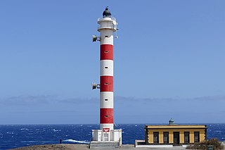
The Punta Abona Lighthouse is an active lighthouse on the south-eastern coast of Tenerife in the Canary islands. It is located between Abades and Poris de Abona, in the municipality of Arico. The lighthouse was the second to be constructed on the rocky headland of Punta Abona, which marks the south-east side of the island, and lies between the Punta de Anaga Lighthouse to the north and the Punta Rasca Lighthouse of Arona to the south.

The Puerto del Rosario Lighthouse also known as the Punta Gaviota Lighthouse is a modern active lighthouse on the Canary island of Fuerteventura. It is located in an industrial area at the north-eastern end of the town of Puerto del Rosario, the capital and major port of the island in the Province of Las Palmas.

The Punta Rasca Lighthouse is an active lighthouse in the municipality of Arona on the Canary Island of Tenerife. The current lighthouse was the second to be constructed on the headland of Punta Rasca, which is located close to the most southerly point on the island at Punta Salemas. It lies between the Punta Abona Lighthouse to the northeast and the Punta de Teno Lighthouse of Buenavista del Norte to the northwest.

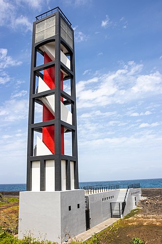
The Punta de Teno Lighthouse is an active lighthouse in the municipality of Buenavista del Norte on the Canary Island of Tenerife. The current lighthouse was the second to be constructed on the narrow rocky headland of Punta de Teno, which is the most westerly point on the island. It is one of seven lighthouses which mark the coastline of Tenerife, and lies between the Punta Rasca Lighthouse to the southeast, and the modern lighthouse of Buenavista to the northeast.
The Puerto de la Cruz Lighthouse is an active lighthouse in Puerto de la Cruz on the northern coast of Tenerife in the Canary Islands. This modern lighthouse is situated within a seafront car park, to the west of the small port in the town. It is one of seven lighthouses which mark the coastline of Tenerife, and lies between two other modern lighthouses of Punta del Hidalgo to the northeast, and Buenavista to the west.

The Punta de Arinaga Lighthouse is an active lighthouse on the Spanish island of Gran Canaria in the Canary islands. The current lighthouse tower is the third to be constructed on the rocky headland of Punta Arinaga, near the town of the same name in the municipality of Agüimes. Arinaga is on the south-east side of the island and marks the coastline between the Maspalomas lighthouse to the south and the Punta de Melenara lighthouse of Telde to the north.

The Buenavista Lighthouse, also known as the Punta de Buenavista lighthouse is an active lighthouse in the municipality of Buenavista del Norte on the northern coast of Tenerife in the Canary Islands.

The Punta de Melenara Lighthouse also known as the Faro de Taliarte is an active 20th century lighthouse on the Spanish island of Gran Canaria in the Canary islands.

Puerto Morelos is one of the eleven municipalities of the Mexican state of Quintana Roo, on the Yucatán Peninsula. It was formed in 2016 from the localities of Puerto Morelos, Leona Vicario and Central Vallarta previously belonging to the municipality of Benito Juárez. In the 2010 census, these three localities recorded a total of 15,725 inhabitants.

The Adra Lighthouse is an active lighthouse near Adra in the Spanish province of Almería on the Mediterranean coast in Andulasia.

The effects of Hurricane Wilma in Mexico severely affected the tourism industry of the Yucatán Peninsula in mid October 2005. Hurricane Wilma developed on October 15 in the Caribbean. Four days later, it intensified into the strongest Atlantic hurricane on record as determined by barometric pressure. Wilma weakened as it moved slowly northwestward, eventually making landfall late on October 21 on the island of Cozumel. At the time, it was a Category 4 hurricane on the Saffir–Simpson scale. Early the next day, the hurricane made another landfall on the Mexican mainland near Puerto Morelos. Wilma exited the Yucatán Peninsula into the Gulf of Mexico on October 23, and a day later it struck Florida.

