
Puget Sound Coast Artillery Museum is a military museum located at Fort Worden State Park on Puget Sound, in the State of Washington. [1] [2] The museum occupies part of Building 201, a former barracks at Fort Worden. [3] [4]
Puget Sound Coast Artillery Museum is a military museum located at Fort Worden State Park on Puget Sound, in the State of Washington. [1] [2] The museum occupies part of Building 201, a former barracks at Fort Worden. [3] [4]

Port Townsend is a city on the Quimper Peninsula in Jefferson County, Washington, United States. The population was 10,148 at the 2020 United States Census. It is the county seat and only incorporated city of Jefferson County.

The SwinomishSWIN-ə-mish are a historically Lushootseed-speaking Native American people in western Washington state in the United States. The Tribe lives in the southeastern part of Fidalgo Island in northern Puget Sound, near the San Juan Islands, in Skagit County, Washington. Skagit County is located about 70 miles (110 km) north of Seattle.

The Olympic Peninsula is a large arm of land in western Washington that lies across Puget Sound from Seattle, and contains Olympic National Park. It is bounded on the west by the Pacific Ocean, the north by the Strait of Juan de Fuca, and the east by Hood Canal. Cape Alava, the westernmost point in the contiguous United States, and Cape Flattery, the northwesternmost point, are on the peninsula. Comprising about 3,600 square miles (9,300 km2), the Olympic Peninsula contained many of the last unexplored places in the contiguous United States. It remained largely unmapped until Arthur Dodwell and Theodore Rixon mapped most of its topography and timber resources between 1898 and 1900.

Admiralty Inlet is a strait in the U.S. state of Washington connecting the eastern end of the Strait of Juan de Fuca to Puget Sound. It lies between Whidbey Island and the northeastern part of the Olympic Peninsula.
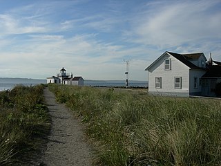
West Point is the westernmost point in Seattle, Washington, United States, jutting into Puget Sound from the Magnolia neighborhood. It also marks the northern extent of Elliott Bay; a line drawn southeastward to Alki Point marks the western extent of the bay. At the point itself is the 1881 West Point Lighthouse, the first manned light station on Puget Sound. Just to the east is King County's sewage treatment plant, and beyond that, Discovery Park, formerly the U.S. Army's Fort Lawton.
Fort Flagler State Park is a public recreation area that occupies the site of Fort Flagler, a former United States Army fort at the northern end of Marrowstone Island in Washington. The state park occupies 1,451 acres (587 ha) at the entrance to Admiralty Inlet and the Marrowstone Point Light lying adjacent. Port Townsend is visible to the northwest, the cranes at the Navy base on Indian Island to the west, and Whidbey Island to the east across Admiralty Inlet. Flagler Road terminates at the park entrance.

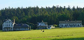
Fort Worden Historical State Park is located in Port Townsend, Washington, on 433 acres originally known as Fort Worden, a United States Army Coast Artillery Corps base constructed to protect Puget Sound from invasion by sea. Fort Worden was named after U.S. Navy Rear Admiral John Lorimer Worden, commander of USS Monitor during the famous Battle of Hampton Roads during the American Civil War.

The Puget Sound War was an armed conflict that took place in the Puget Sound area of the state of Washington in 1855–56, between the United States military, local militias and members of the Native American tribes of the Nisqually, Muckleshoot, Puyallup, and Klickitat. Another component of the war, however, were raiders from the Haida and Tlingit who came into conflict with the United States Navy during contemporaneous raids on the native peoples of Puget Sound. Although limited in its magnitude, territorial impact and losses in terms of lives, the conflict is often remembered in connection to the 1856 Battle of Seattle and to the execution of a central figure of the war, Nisqually Chief Leschi. The contemporaneous Yakima War may have been responsible for some events of the Puget Sound War, such as the Battle of Seattle, and it is not clear that the people of the time made a strong distinction between the two conflicts.

Fort Casey State Park is located on Whidbey Island, in Island County, Washington state. It is a Washington state park and a historic district within the U.S. Ebey's Landing National Historical Reserve.

The Puget Sound Navigation Company (PSNC) was founded by Charles E. Peabody in 1898. Today the company operates an international passenger and vehicle ferry service between Port Angeles, Washington, United States and Victoria, British Columbia, Canada on the MV Coho, through its operating company, Black Ball Ferry Line.


The Upper Skagit Indian Tribe is a federally recognized Native American tribe located in the state of Washington. Before European colonization, the tribe occupied lands along the Skagit River, from as far downstream as present-day Mount Vernon, Washington, and villages going north as far as Newhalem along the Skagit River, as well as lands on the Baker, and the Sauk rivers.
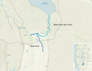
The Black River is a tributary of the Duwamish River in King County in the U.S. state of Washington. It drained Lake Washington until 1916, when the opening of the Lake Washington Ship Canal lowered the lake, causing part of the Black River to dry up. It still exists as a dammed stream about 2 miles (3.2 km) long.
Port Susan is a bay and strait located in the U.S. state of Washington. Part of the Whidbey Island Basin of Puget Sound, Port Susan is bounded by Camano Island to the west and the mainland to the east. The Stillaguamish River empties into the northern end of Port Susan. To the south, Port Susan connects with the rest of Puget Sound via Possession Sound and Saratoga Passage. A swampy waterway connects the northern end of Port Susan with Skagit Bay. This waterway also separates Camano Island from the mainland.

The Puget Sound region is a coastal area of the Pacific Northwest in the U.S. state of Washington, including Puget Sound, the Puget Sound lowlands, and the surrounding region roughly west of the Cascade Range and east of the Olympic Mountains. It is characterized by a complex array of saltwater bays, islands, and peninsulas carved out by prehistoric glaciers.
The Swinomish Channel is an 11-mile (18 km) long salt-water channel in Washington state, United States, which connects Skagit Bay to the south and Padilla Bay to the north, separating Fidalgo Island from mainland Skagit County. The Swinomish Channel is the smallest of the three entrances to Puget Sound—the other two being Deception Pass and Admiralty Inlet.
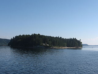
Ketron Island is an island and a census-designated place (CDP) in Pierce County, Washington, United States. The island had a population of 24 persons according to the 2000 census, and 17 persons at the 2010 census.
The 14th Coast Artillery Regiment was a Coast Artillery regiment in the United States Army. It served as the Regular Army component of the Harbor Defenses (HD) of Puget Sound, Washington state from 1924 through October 1944, when it was broken up and disbanded as part of an Army-wide reorganization. The 248th Coast Artillery Regiment was the Washington National Guard component of those defenses.
Fort Whitman (Washington) was an Endicott Board fortification on Goat Island, Puget Sound, Washington state, just offshore of La Conner, a part of the Harbor Defenses of Puget Sound. It comprised a single 4 gun 6" DC battery, Battery Harrison, and mine control structures. The usual barracks and other support facilities were temporary and built for the duration, excepting a caretaker's quarters. It protected the confined back passage east of Fidalgo Island, Skagit Bay. By World War II, the six-inch DCs were no longer required; the main armament was 37mm AMTB guns.
The 248th Coast Artillery Regiment was a Coast Artillery Corps regiment in the Washington National Guard. Including its predecessor battalion, it garrisoned the Harbor Defenses of Puget Sound, Washington 1924–1944.
48°08′04″N122°45′58″W / 48.1344°N 122.7660°W
| | This Washington state museum-related article is a stub. You can help Wikipedia by expanding it. |