
Arico is the name of a municipality and a village in the southeastern part of the island of Tenerife, one of the Canary Islands, Spain. It is part of the Province of Santa Cruz de Tenerife. The municipality is located in the southeastern part of the island, and extends for 178,76 square kilometers from the mountainous interior to the beaches on the Atlantic. Its estimated population is around 7,500. The TF-1 motorway passes through the eastern part of the municipality.

Adeje is a town and municipality in the southwestern part of the island of Tenerife, one of the Canary Islands, and part of the province of Santa Cruz de Tenerife, Spain. The town Adeje is located 4 km from the coast, 8 km north of the resort town Los Cristianos, 60 km southwest of the island capital Santa Cruz de Tenerife and about 17 km northwest of Tenerife South Airport.
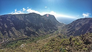
Valle Gran Rey is a municipality in the western part of the island La Gomera, in the province of Santa Cruz de Tenerife of the Canary Islands, Spain. The Guanche name of the area was Orone. The seat of the municipality since 1930 is La Calera; previously it was in Arure.

The Tostón Lighthouse or El Cotillo Lighthouse is an active lighthouse on the Canary island of Fuerteventura. The lighthouse is situated on the northwestern coast of the island near to the village of El Cotillo, in the municipality of La Oliva. In conjunction with the lights at Pechiguera and Punta Martiño, it marks the narrow La Bocayna strait that separates Fuerteventura from the adjacent island of Lanzarote.
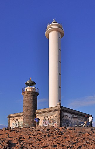
The Pechiguera or Punta Pechiguera Lighthouse is an active lighthouse on the Canary island of Lanzarote. It is the second lighthouse to be built at Punta Pechiguera, which is at the south-western end of the island.

The Morro Jable Lighthouse is an active lighthouse on the Canary island of Fuerteventura. The lighthouse is situated at the edge of the beach near the town and resort of Morro Jable.
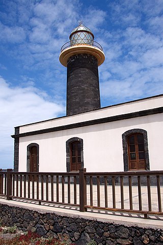
The Punta Jandía Lighthouse is an active lighthouse on the Canary island of Fuerteventura. The name derives from its location on the Punta de Jandía, at the end of the much larger Jandía peninsula, which forms the south west part of the island.
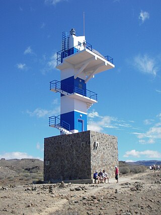
The Punta del Castillete Lighthouse is an active lighthouse on the Canary island of Gran Canaria. It is located on cliffs above the resort and fishing harbour of Puerto de Mogán, in the municipality of Mogán. Punta Castillete is on the south-western side of the island facing the Atlantic Ocean, and lies between Maspalomas Lighthouse to the south and the lighthouse of Punta Sardina to the north.

The Punta Orchilla Lighthouse is an active lighthouse on the Canary island of El Hierro in the municipality of El Pinar. The need for a lighthouse on the island was highlighted in the second maritime lighting plan for the Canaries, and it first became operational in 1933.

Punta Cumplida Lighthouse is an active 19th century Spanish lighthouse on the Canary island of La Palma in the municipality of Barlovento. Punta Cumplida is the oldest of the four main lighthouses on La Palma, each one being located near to a different cardinal point of the island. Punta Cumplida marks the north-eastern tip; Fuencaliente the southern point, and the two modern lighthouses at Punta Lava and Arenas Blancas, the eastern and western points respectively.

The Punta Sardina Lighthouse is an active lighthouse on the Canary island of Gran Canaria. It is located north of the small town of Sardina, in the municipality of Gáldar. The Punta Sardina light marks the north-western extremity of the island, and lies between the Punta del Castillete lighthouse near Puerto de Mogán to the south and the La Isleta lighthouse of Las Palmas to the east.
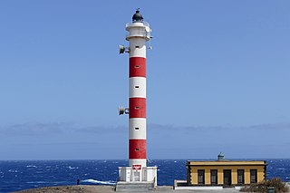
The Punta Abona Lighthouse is an active lighthouse on the south-eastern coast of Tenerife in the Canary islands. It is located between Abades and Poris de Abona, in the municipality of Arico. The lighthouse was the second to be constructed on the rocky headland of Punta Abona, which marks the south-east side of the island, and lies between the Punta de Anaga Lighthouse to the north and the Punta Rasca Lighthouse of Arona to the south.

The Puerto del Rosario Lighthouse also known as the Punta Gaviota Lighthouse is a modern active lighthouse on the Canary island of Fuerteventura. It is located in an industrial area at the north-eastern end of the town of Puerto del Rosario, the capital and major port of the island in the Province of Las Palmas.

The Punta Rasca Lighthouse is an active lighthouse in the municipality of Arona on the Canary Island of Tenerife. The current lighthouse was the second to be constructed on the headland of Punta Rasca, which is located close to the most southerly point on the island at Punta Salemas. It lies between the Punta Abona Lighthouse to the northeast and the Punta de Teno Lighthouse of Buenavista del Norte to the northwest.

The Punta de Teno Lighthouse is an active lighthouse in the municipality of Buenavista del Norte on the Canary Island of Tenerife. The current lighthouse was the second to be constructed on the narrow rocky headland of Punta de Teno, which is the most westerly point on the island. It is one of seven lighthouses which mark the coastline of Tenerife, and lies between the Punta Rasca Lighthouse to the southeast, and the modern lighthouse of Buenavista to the northeast.
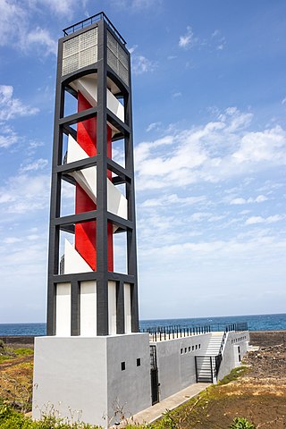
The Puerto de la Cruz Lighthouse is an active lighthouse in Puerto de la Cruz on the northern coast of Tenerife in the Canary Islands. This modern lighthouse is situated within a seafront car park, to the west of the small port in the town. It is one of seven lighthouses which mark the coastline of Tenerife, and lies between two other modern lighthouses of Punta del Hidalgo to the northeast, and Buenavista to the west.

The Punta del Hidalgo Lighthouse is an active lighthouse in Punta del Hidalgo within the municipality of San Cristóbal de La Laguna on the northeast coast of Tenerife in the Canary Islands.

The Buenavista Lighthouse, also known as the Punta de Buenavista lighthouse is an active lighthouse in the municipality of Buenavista del Norte on the northern coast of Tenerife in the Canary Islands.

The Punta de Melenara Lighthouse also known as the Faro de Taliarte is an active 20th century lighthouse on the Spanish island of Gran Canaria in the Canary Islands.

Punta Lava Lighthouse is an active 20th century Spanish lighthouse on the Canary island of La Palma. It is located in the municipality of Tazacorte, near the village of La Bombilla on the western side of the island. The larger settlement of Puerto Naos lies 2 kilometres to the south-west.


