Puntal dels Escambrons

Last updated
Puntal dels Escambrons

Puntal dels Escambrons80.JPG

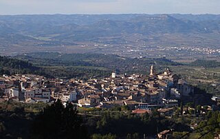
Puntal dels Escambrons seen from Riba-roja d'Ebre
Highest point
Elevation 500 m (1,600 ft)
Coordinates 41°16′33″N0°25′57″E / 41.27583°N 0.43250°E / 41.27583; 0.43250 Coordinates: 41°16′33″N0°25′57″E / 41.27583°N 0.43250°E / 41.27583; 0.43250
Geography
Catalonia location map.svg
Red triangle with thick white border.svg
Puntal dels Escambrons
Catalonia, Spain
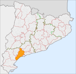
Location Segrià, Ribera d'Ebre, Catalonia
Parent range Isolated hill in the Catalan Central Depression
Geology
Mountain type Conglomerate
Climbing
First ascent Unknown
Easiest route From Riba-roja d'Ebre or Almatret

Puntal dels Escambrons is a mountain of Catalonia, Spain.

Catalonia Autonomous area of northeastern Spain

Catalonia is an autonomous community in Spain on the northeastern corner of the Iberian Peninsula, designated as a nationality by its Statute of Autonomy. Catalonia consists of four provinces: Barcelona, Girona, Lleida, and Tarragona. The capital and largest city is Barcelona, the second-most populated municipality in Spain and the core of the sixth most populous urban area in the European Union. It comprises most of the territory of the former Principality of Catalonia. It is bordered by France (Occitanie) and Andorra to the north, the Mediterranean Sea to the east, and the Spanish autonomous communities of Aragon to the west and Valencia to the south. The official languages are Catalan, Spanish, and the Aranese dialect of Occitan.

Spain Kingdom in Southwest Europe

Spain, officially the Kingdom of Spain, is a country mostly located in Europe. Its continental European territory is situated on the Iberian Peninsula. Its territory also includes two archipelagoes: the Canary Islands off the coast of Africa, and the Balearic Islands in the Mediterranean Sea. The African enclaves of Ceuta, Melilla, and Peñón de Vélez de la Gomera make Spain the only European country to have a physical border with an African country (Morocco). Several small islands in the Alboran Sea are also part of Spanish territory. The country's mainland is bordered to the south and east by the Mediterranean Sea except for a small land boundary with Gibraltar; to the north and northeast by France, Andorra, and the Bay of Biscay; and to the west and northwest by Portugal and the Atlantic Ocean.

Contents

Geography

With an elevation of 500 metres above sea level the Puntal dels Escambrons is the highest hill of the Segrià comarca. It is located in the Almatret, Segrià, and Riba-roja d'Ebre, Ribera d'Ebre, municipal limits. [1]

Segrià Comarca in Catalonia, Spain

Segrià is a comarca (county) in the west of Catalonia, Spain, bordering Aragon. As of 2001, over two thirds of its population live in the capital city of Lleida, which is also Catalonia's largest municipality, and remains the most populated comarca in the Lleida province. It takes its name from the river Segre.

Almatret Municipality in Catalonia, Spain

Almatret is a municipality in the comarca of the Segrià in Catalonia, Spain.

Riba-roja dEbre Municipality in Catalonia, Spain

Riba-roja d'Ebre is a municipality in the comarca of the Ribera d'Ebre in southern Catalonia, Spain. It is the site of a large hydroelectric power station, on the Ebro river. The whole area is mountainous.

A wind farm, the Parc Eòlic Els Escambrons is being built on this mountain and neighboring ridges. [2]

Wind farm group of wind turbines

A wind farm or wind park is a group of wind turbines in the same location used to produce electricity. A large wind farm may consist of several hundred individual wind turbines and cover an extended area of hundreds of square miles, but the land between the turbines may be used for agricultural or other purposes. A wind farm can also be located offshore.

See also

Related Research Articles

Baix Camp Comarca in Catalonia, Spain

Baix Camp is a comarca of Catalonia. It is one of the three comarques into which Camp de Tarragona was divided in the comarcal division of 1936.

Montsià Comarca in Catalonia, Spain

Montsià is the southernmost comarca (county) of Catalonia in Spain. Its capital and largest city is Amposta.

Tivissa Municipality in Catalonia, Spain

Tivissa is a municipality in the comarca of Ribera d'Ebre, Catalonia, Spain. It is located below the La Llena massif. As well as the village of Tivissa itself, the municipality also includes the village of La Serra d'Almos, at the feet of the Montalt mountains, and the hamlets of Darmós and Llaberia.

Ascó Municipality in Catalonia, Spain

Ascó is a large village in the comarca of Ribera d'Ebre, Catalonia, Spain, on the right bank of the Ebre river at the feet of the Serra de la Fatarella range. The village of Ascó is known for its nuclear power station, and for excellent fishing in the river.

Móra dEbre Municipality in Catalonia, Spain

Móra d'Ebre is the capital of the comarca of the Ribera d'Ebre in Catalonia, Spain. It is situated on the right bank of the Ebre river in the Móra Hollow, and is served by the N-420 road to Reus and Gandesa, the N-230 road to Lleida. The RENFE railway line between Tarragona and Saragossa runs along the left bank of the river, with a station at Móra la Nova opposite the urban centre of Móra d'Ebre.

Móra la Nova Municipality in Catalonia, Spain

Móra la Nova is a municipality in the comarca, or district, of the Ribera d'Ebre in Catalonia, Spain. It is situated on the left bank of the Ebre river, facing the district capital Móra d'Ebre. It is served by a RENFE railway station on the line between Tarragona and Zaragoza and by the N-420 road to Gandesa and Reus.

Alfarràs Municipality in Catalonia, Spain

Alfarràs is a municipality in the comarca of the Segrià in Catalonia, Spain. It is situated on the right bank of the Noguera Ribagorçana river, and receives irrigation water from the Aragon and Catalonia canal. The town is served by the N-230 road between Balaguer and Binéfar.

La Portella Municipality in Catalonia, Spain

La Portella is a municipality in the comarca of the Segrià in Catalonia, Spain. It is situated on the right bank of the Noguera Ribagorçana river. A local road links the municipality with Lleida.

Gimenells i el Pla de la Font Municipality in Catalonia, Spain

Gimenells i el Pla de la Font is a municipality in Segrià, Catalonia, Spain. It has an area of 55.8 square kilometres and in 2011 had a population of 1,169. The mayor is Dante Pérez Berenguer.

Outline of Catalonia Overview of and topical guide to Catalonia

The following outline is provided as an overview of and topical guide to Catalonia:

Ports de Tortosa-Beseit mountain

Ports de Tortosa-Beseit, also known as Ports de Beseit, or simply as Els Ports[əls ˈpɔɾts] or Lo Port[lu ˈpɔɾt] by locals, is a limestone mountain massif located at the north-eastern end of the Sistema Ibérico, a complex system of mountain ranges and massifs in the centre of the Iberian Peninsula. Its highest point is Mont Caro, 1,441 m. Rivers such as the Matarranya and the Sénia have their source in these mountains.

Corbera dEbre Municipality in Catalonia, Spain

Corbera d'Ebre is a municipality in the comarca of la Terra Alta in Catalonia, Spain. It is one of the 12 municipalities comprising the wine-growing region of the Spanish Denominación de Origen classification of the Spanish wine Terra Alta.

Torrebesses Municipality

'Torrebesses is a municipality in the comarca of the Segrià in Catalonia, Spain.

Montmeneu mountain in Spain

Montmeneu or Punta de Montmaneu is a mountain in Catalonia, Spain. It is located within the La Granja d'Escarp and Seròs municipal limits, Segrià.

La Palma dEbre Municipality in Catalonia, Spain

La Palma d'Ebre is a municipality in the comarca of Ribera d'Ebre, Tarragona Province, Catalonia, Spain. Despite its name, it is not located close to the Ebre river. There is a reservoir less than 1 km north of the town.

La Torre de lEspanyol Municipality in Catalonia, Spain

La Torre de l'Espanyol is a municipality in the comarca of Ribera d'Ebre, Tarragona Province, Catalonia, Spain.

Corps of Firefighters of Catalonia

The Corps of Firefighters of Catalonia is the fire department of Catalonia, Spain. The body was established on June 27, 1980, shortly after the second restoration of the Government of Catalonia. It has responsibility managing all tasks related to firefighting, fire prevention, civil protection, maritime rescue, and traffic accidents.

References

  1. "Mapa Topogràfic de Catalunya". Institut Cartogràfic de Catalunya. Retrieved May 22, 2010..
  2. Fersa pone en marcha un parque eólico en Tarragona