
Orunia-Św. Wojciech-Lipce is one of the quarters of the city of Gdańsk, Poland.
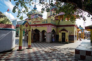
Mahottari District, a part of Madhesh Province, is one of the seventy-seven districts of Nepal. The district, with Jaleshwar as its district headquarter, covers an area of 1,002 km2 (387 sq mi) and had a population of 553,481 in 2001, 627,580 in 2011 and 705,838 in 2021 census. Its headquarters is located in Jaleshwar, a neighbouring town of the historical city of Janakpur. The name Jaleshwar means the 'God in Water'. One can find a famous temple of Lord Shiva in Water there. Jaleshwar lies at a few kilometres distance from the Nepal-India border and has a majority Maithili population.

Bligh Island Marine Provincial Park is a provincial park in British Columbia, Canada.
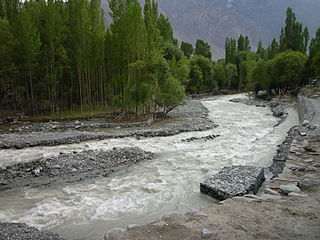
Shigar River is located in the mountainous Baltistan region of northern Pakistan. The Shigar is formed from the melted water of the Baltoro Glacier and Biafo Glacier. It flows through the Shigar Valley. The river is a tributary to the Indus River and meets the Indus in Skardu Valley. The Shigar is the main right-bank tributary of the Indus River Valley in the Skardu Valley.
The Upper Similkameen Indian Band or Upper Smelqmix, is a First Nations band government in the Canadian province of British Columbia, whose head offices are located in town of Hedley in the Similkameen Country. They are a member of the Okanagan Nation Alliance.
The Lytton First Nation, a First Nations band government, has its headquarters at Lytton in the Fraser Canyon region of the Canadian province of British Columbia. While it is the largest of all Nlaka'pamux bands, unlike all other governments of the Nlaka'pamux (Thompson) people, it is not a member of any of the three Nlaka'pamux tribal councils, which are the Nicola Tribal Association, the Fraser Canyon Indian Administration and the Nlaka'pamux Nation Tribal Council.
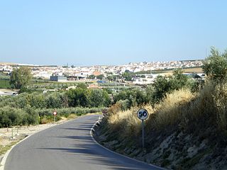
Moriles is a town in the province of Córdoba. In 2018 it had a population of 3,726. The municipality covers an area of about 20 km2 and has a population density of about 194 inhabitants/km2. The town is located about 65 km south of the provincial capital, Córdoba, at an altitude of 375 m above sea level, at co-ordinates 37°26′0″N4°37′0″W.
Long Point Wildlife Refuge is a wildlife refuge and nature reserve located in West Tisbury, Massachusetts. The property is owned by The Trustees of Reservations; it has grown in size since its first purchase in 1979.
Highwood Mountains National Forest was established as the Highwood Mountains Forest Reserve by the U.S. Forest Service in Montana on April 12, 1906 with 45,080 acres (182.4 km2). It became a National Forest on March 4, 1907. On July 1, 1908 the entire forest was combined with Little Belt, Snowy Mountains and Little Rockies National Forests to establish Jefferson National Forest (Montana) and the name was discontinued. The lands are now included in Lewis and Clark National Forest.
Roopnagar is a village in the Udaipur section of Rajasthan. It is situated on the summit of the Aravallis, between the Desuri and Someshwar passes. Steep and precipitous hill-sides render the village unapproachable from the north and east. It is defended by outworks overlooking the plains and the Desuri pass on the west and south. Founded about 1772 by Thakur Veeramdeo, it is the principal seat of Solankis in Mewar, and is one of Greater 32 Nobles of Mewar court. The site was chosen solely for defence of the Pass of Desuri and Someshwar. There is no cultivation belonging to the town, nor is any revenue derived from it. Thakur of Roopnagar held the jagir of 84 villages on both sides of the Aravalli Range.
M'Clure Bay is a Peel Soundmap waterway in Qikiqtaaluk Region, Nunavut, Canada. It is located on the western side of Somerset Island,map between Aston Baymap and Birmingham Baymap.
Rampur is a town in Ranchi district, Jharkhand, India.
The Tseycum First Nation is a First Nations government located on Vancouver Island. In the 1850s, they were signatories to the Douglas Treaties.

The Yorktown Formation is a mapped bedrock unit in the Coastal Plain of Maryland, Virginia, North Carolina and South Carolina. It is overconsolidated and highly fossiliferous.

English Strait is the 10.5-mile (17-km) long and 1.2-mile (2-km) wide strait lying between Greenwich Island and Robert Island in the South Shetland Islands, Antarctica. Trending southeast-northwest, and entered between Santa Cruz Point and Edwards Point in the south, and Fort William Point and Okol Rocks, Aitcho Islands in the north. The name dates back to 1822 and is established in international usage.

Gopalganj Assembly constituency is an assembly constituency in Gopalganj district in the Indian state of Bihar.
Nabisunsa Girls Secondary School is an all-girl boarding school located in Kampala, Uganda. The school was founded in 1954 by Prince Badru Kakungulu, a Buganda Royal, in 1954, to offer post-primary education to the Muslim girl-child. Today it admits girls of all faiths.
Pleasant View is an unincorporated community in Fayette County, in the U.S. state of Ohio.

National Highway 57, previously numbered as NH 224, is a primary National Highway in India connecting Balangir and Khordha in the state of Odisha.
National Highway 157, commonly referred to as NH 157 is a national highway in India. It is a spur road of National Highway 57. NH-157 traverses the state of Odisha in India.


