
The Tumen River, also known as the Tuman River or Duman River, is a 521-kilometre (324 mi) long river that serves as part of the boundary between China, North Korea (right) and Russia (left), rising on the slopes of Mount Paektu and flowing into the Sea of Japan. The river has a drainage basin of 33,800 km2 (13,100 sq mi).
Naval warfare is combat in and on the sea, the ocean, or any other battlespace involving a major body of water such as a large lake or wide river.

Yantai, formerly known as Chefoo, is a coastal prefecture-level city on the Shandong Peninsula in northeastern Shandong province of the People's Republic of China. Lying on the southern coast of the Bohai Strait, Yantai borders Qingdao on the southwest and Weihai on the east, with sea access to both the Bohai Sea and the Yellow Sea. It is the largest fishing seaport in Shandong. Its population was 7,102,116 during the 2020 census, of whom 3,184,299 lived in the built-up area made up of the 5 urban districts of Zhifu, Laishan, Fushan, Muping, and Penglai.

The Geum River is a major river of South Korea that originates in Jangsu-eup, North Jeolla Province. It flows northward through North Jeolla and North Chungcheong Provinces and then changes direction in the vicinity of Greater Daejeon and flows southwest through South Chungcheong Province before emptying into the Yellow Sea near Gunsan.

Kaesong is a special city in the southern part of North Korea, and the capital of Korea during the Taebong kingdom and subsequent Goryeo dynasty. The city is near the Kaesong Industrial Region close to the border with South Korea and contains the remains of the Manwoldae palace. Called Songdo while it was the ancient capital of Goryeo, the city prospered as a trade centre that produced Korean ginseng. Kaesong now functions as North Korea's light industry centre.

Wonju is the most populous city in Gangwon Province, South Korea, with a population of 364,860 as of 2023. The city is located approximately 140 kilometres (87 mi) east of Seoul.

Lüshunkou District is a district of Dalian, Liaoning province, China. The district's area is 512.15 km2 (197.74 sq mi) and its permanent population as of 2020 is 398,579.
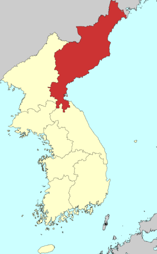
Hamgyong Province was one of the Eight Provinces of Korea during the Joseon Dynasty. Hamgyong was located in the northeast of Korea. The provincial capital was Hamhung.
The Kwantung Leased Territory was a leased territory of the Empire of Japan in the Liaodong Peninsula from 1905 to 1945.

Gwangju is a city in Gyeonggi Province, South Korea, a suburb southeast of Seoul. The city is not to be confused with the much larger Gwangju Metropolitan City, former capital of South Jeolla Province, or Guangzhou, the city of Guangdong, China in Hanja.

The Taedong River (Korean: 대동강) is a large river in North Korea. The river rises in the Rangrim Mountains of the country's north where it then flows southwest into Korea Bay at Namp'o. In between, it runs through the country's capital, Pyongyang. Along the river are landmarks such as the Juche Tower and Kim Il-sung Square.

The Nakdong River or Nakdonggang is the longest river in South Korea, which passes through the major cities of Daegu and Busan. It takes its name from its role as the eastern border of the Gaya confederacy during Korea's Three Kingdoms Era.

Haeju is a city located in South Hwanghae Province near Haeju Bay in North Korea. It is the administrative centre of South Hwanghae Province. As of 2008, the population of the city is estimated to be 273,300. At the beginning of the 20th century, it became a strategic port in Sino-Korean trade. Haeju has chemical-related enterprises and a cement factory.

Ganghwa Island (Korean: 강화도), also Ganghwado, is an island in Ganghwa County, Incheon, South Korea. It is located in the Yellow Sea and in an estuary of the Han River.

Riwŏn or Iwon County is a county in South Hamgyŏng province, North Korea. It is located at the province's northeastern tip and borders the Sea of Japan to the southeast.

The Port of Busan is the largest port in South Korea, located in the city of Busan, South Korea. Its location is known as Busan Harbor.
Riwŏn is the seat of Riwŏn County in South Hamgyŏng province, North Korea.
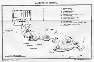
Zhapu, alternately romanized as Chapoo or Chapu, is a town under the administration of Pinghu, in the north of Zhejiang Province, China. It is located along the northern shore of Hangzhou Bay in the southeastern part of Pinghu and borders Haiyan County to its south and southeast. The town covers an area of 54.4 square kilometers and has a population of 54,000.
The Hamgyong Mountains, officially known as the Gangbaekjeonggan and formerly known as the Pepi Shan or Tumen Mountains, is a North Korean mountain range. It lies in the northeast quarter of the country, extending for about 350 kilometers (220 mi) southwest and northeast parallel to the Sea of Japan. Its northern terminus is in the Tumen Valley. To its west are the Kaema Highlands.

Sunheung is a township administered as part of the municipality of Yeongju in North Gyeongsang, South Korea. The present local government administers an area of 54.35 square kilometers (20.98 sq mi).
