Ur was an important Sumerian city-state in ancient Mesopotamia, located at the site of modern Tell el-Muqayyar in Dhi Qar Governorate, southern Iraq. Although Ur was once a coastal city near the mouth of the Euphrates on the Persian Gulf, the coastline has shifted and the city is now well inland, on the south bank of the Euphrates, 16 km (10 mi) from Nasiriyah in modern-day Iraq. The city dates from the Ubaid period c. 3800 BC, and is recorded in written history as a city-state from the 26th century BC, its first recorded king being King Tuttues.

Eridu was a Sumerian city located at Tell Abu Shahrain, also Abu Shahrein or Tell Abu Shahrayn, an archaeological site in Lower Mesopotamia. It is located in Dhi Qar Governorate, Iraq, near the modern city of Basra. Eridu is traditionally considered the earliest city in southern Mesopotamia based on the Sumerian King List. Located 12 kilometers southwest of the ancient site of Ur, Eridu was the southernmost of a conglomeration of Sumerian cities that grew around temples, almost in sight of one another. The city gods of Eridu were Enki and his consort Damkina. Enki, later known as Ea, was considered to have founded the city. His temple was called E-Abzu, as Enki was believed to live in Abzu, an aquifer from which all life was thought to stem. According to Sumerian temple hymns, another name for the temple of Ea/Enki was called Esira (Esirra).
"... The temple is constructed with gold and lapis lazuli, Its foundation on the nether-sea (apsu) is filled in. By the river of Sippar (Euphrates) it stands. O Apsu pure place of propriety, Esira, may thy king stand within thee. ..."

Sumer is the earliest known civilization, located in the historical region of southern Mesopotamia, emerging during the Chalcolithic and early Bronze Ages between the sixth and fifth millennium BC. Like nearby Elam, it is one of the cradles of civilization, along with Egypt, the Indus Valley, the Erligang culture of the Yellow River valley, Caral-Supe, the Cucuteni–Trypillia culture of the Carpathian Mountains, and Mesoamerica. Living along the valleys of the Tigris and Euphrates rivers, Sumerian farmers grew an abundance of grain and other crops, a surplus which enabled them to form urban settlements. The world's earliest known texts come from the Sumerian cities of Uruk and Jemdet Nasr, and date to between c. 3350 – c. 2500 BC, following a period of proto-writing c. 4000 – c. 2500 BC.

Larsa, also referred to as Larancha/Laranchon by Berossos and connected with the biblical Ellasar, was an important city-state of ancient Sumer, the center of the cult of the sun god Utu with his temple E-babbar. It lies some 25 km (16 mi) southeast of Uruk in Iraq's Dhi Qar Governorate, near the east bank of the Shatt-en-Nil canal at the site of the modern settlement Tell as-Senkereh or Sankarah.
Uruk, known today as Warka, was an ancient city in the Near East, located east of the current bed of the Euphrates River, on an ancient, now-dried channel of the river. The site lies 93 kilometers northwest of ancient Ur, 108 kilometers southeast of ancient Nippur, and 24 kilometers southeast of ancient Larsa. It is 30 km (19 mi) east of modern Samawah, Al-Muthannā, Iraq.

Nippur was an ancient Sumerian city. It was the special seat of the worship of the Sumerian god Enlil, the "Lord Wind", ruler of the cosmos, subject to An alone. Nippur was located in modern Nuffar 5 miles north of modern Afak, Al-Qādisiyyah Governorate, Iraq. It is roughly 200 kilometers south of modern Baghdad and about 96.54 km southeast of the ancient city of Babylon. Occupation at the site extended back to the Ubaid period, the Uruk period, and the Jemdet Nasr period. The origin of the ancient name is unknown but different proposals have been made.
Lagash was an ancient city-state located northwest of the junction of the Euphrates and Tigris rivers and east of Uruk, about 22 kilometres (14 mi) east of the modern town of Al-Shatrah, Iraq. Lagash was one of the oldest cities of the Ancient Near East. The ancient site of Nina is around 10 km (6.2 mi) away and marks the southern limit of the state. Nearby Girsu, about 25 km (16 mi) northwest of Lagash, was the religious center of the Lagash state. The Lagash state's main temple was the E-ninnu at Girsu, dedicated to the god Ningirsu. The Lagash state incorporated the ancient cities of Lagash, Girsu, Nina.

Dhi Qar Governorate is a governorate in southern Iraq, in the Arabian Peninsula. The provincial capital is Nasiriyah. Prior to 1976 the governorate was known as Muntafiq Governorate. Thi Qar was the heartland of the ancient Iraqi civilization of Sumer, and includes the ruins of Ur, Eridu, Lagash, Larsa, Girsu, Umma, and Bad-tibira. The southern area of the governorate is covered by Mesopotamian Marshes.
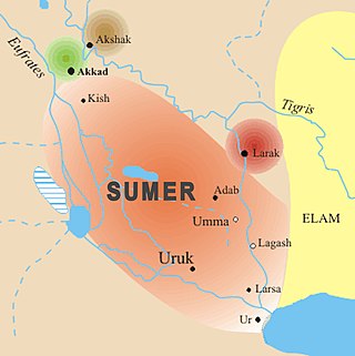
Umma (Sumerian: 𒄑𒆵𒆠ummaKI; in modern Dhi Qar Province in Iraq, was an ancient city in Sumer. There is some scholarly debate about the Sumerian and Akkadian names for this site. Traditionally, Umma was identified with Tell Jokha. More recently it has been suggested that it was located at Umm al-Aqarib, less than 7 km to its northwest or was even the name of both cities. One or both were the leading city of the Early Dynastic kingdom of Gišša, with the most recent excavators putting forth that Umm al-Aqarib was prominent in EDIII but Jokha rose to preeminence later. The town of KI.AN was also nearby. KI.AN, which was destroyed by Rimush, a ruler of the Akkadian Empire. There are known to have been six gods of KI.AN including Gula KI.AN and Sara KI.AN.
Bad-tibira, "Wall of the Copper Worker(s)", or "Fortress of the Smiths", identified as modern Tell al-Madineh, between Ash Shatrah and Tell as-Senkereh and 33 kilometers northeast of ancient Girsu in southern Iraq, was an ancient Sumerian city on the Iturungal canal, which appears among antediluvian cities in the Sumerian King List. Its Akkadian name was Dûr-gurgurri. It was also called Παντιβίβλος (Pantibiblos) by Greek authors such as Berossus, transmitted by Abydenus and Apollodorus. This may reflect another version of the city's name, Patibira, "Canal of the Smiths".
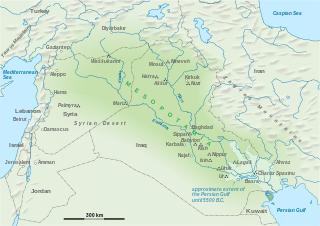
The Civilization of Mesopotamia ranges from the earliest human occupation in the Paleolithic period up to Late antiquity. This history is pieced together from evidence retrieved from archaeological excavations and, after the introduction of writing in the late 4th millennium BC, an increasing amount of historical sources. While in the Paleolithic and early Neolithic periods only parts of Upper Mesopotamia were occupied, the southern alluvium was settled during the late Neolithic period. Mesopotamia has been home to many of the oldest major civilizations, entering history from the Early Bronze Age, for which reason it is often called a cradle of civilization.

Girsu was a city of ancient Sumer, situated some 25 km (16 mi) northwest of Lagash, at the site of what is now Tell Telloh in Dhi Qar Governorate, Iraq. As the religious center of the kingdom of Lagash, it contained significant temples to the god Ningirsu (E-ninnu) and his wife Bau and hosted multi-day festivals in their honor.
Al-Shatrah is a town in southern Iraq, located north of Nasiriyah. It is the administrative capital of the al-Shatrah District, a part of the Dhi Qar Governorate. Al-Shatrah is situated along the Gharraf Canal at the intersection with Highway 7. It lies 22.35 km west of the ancient city of Lagash. In 2009, it had a population estimated 254,000.

Zabala, also Zabalam was a city of ancient Sumer in Mesopotamia, located in what is now the Dhi Qar governorate in Iraq. In early archaeology this location was also called Tel el-Buzekh. Locally it is called Tell Bzikh. Zabala was at the crossing of the ancient Iturungal and Ninagina canals, 10 kilometers to the northwest of Umma. The city's deity was Inanna of Zabala. A cuneiform tablet from Zabala contains one of only a few metro-mathematical tables of area measures from the Early Dynastic Period.
Akshak was a city of ancient Sumer, situated on the northern boundary of Akkad, sometimes identified with Babylonian Upi. It is known, based on an inscription "‘Ur-kisala, the sangu-priest of Sin of Akshak, son of Na-ti, pasisu-priest of Sin to Salam presented [this statue]." that there was a temple of the god Sin in Akshak.
Khafajah or Khafaje, ancient Tutub, is an archaeological site in Diyala Governorate, Iraq 7 miles (11 km) east of Baghdad. Khafajah lies on the Diyala River, a tributary of the Tigris. Occupied from the Uruk and Jemdet Nasr periods through the end of the Old Babylonian Empire, it was under the control of the Akkadian Empire and then the Third Dynasty of Ur in the 3rd millennium BC. It then became part of the empire of the city-state of Eshnunna lying 12 miles (19 km) southwest of that city, about 5 miles (8.0 km) from the ancient city of Shaduppum, and near Tell Ishchali, both which Eshnunna also controlled. It then fell to Babylonia before falling into disuse.
Mashkan-shapir was an ancient tell roughly 30 kilometres (19 mi) north of Nippur and around 90 miles (140 km) southeast of Baghdad. The city god of Mashkan-shapir was Nergal and a temple named Meslam dedicated to him was built there. It is about 20 kilometers south of ancient Malgium. The remnants of a large watercourse, thought to be an ancient bed of the Tigris or Euphrates, pass close to the city.

Nasiriyah, also spelled Nassiriya or Nasiriya, is a city in Iraq, the capital of the Dhi Qar Governorate. It lies on the lower Euphrates, about 360 km south-southeast of Baghdad, near the ruins of the ancient city of Ur. Its population in 2018 was about 558,000, making it the ninth-largest city in Iraq. It had a diverse population of Muslims, Mandaeans and Jews in the early 20th century; today its inhabitants are predominantly Shia Muslims.
Tell Dehaila is an ancient tell, or archaeological site in Iraq. Remains at the site range from the Isin-Larsa/Old-Babylonian to Neo-Babylonian periods.

