
Sandwip is an island located along the southeastern coast of Bangladesh in the Chittagong District. Along with the island of Urir Char, it is part of the Sandwip Upazila.
The Baharistan-i-Ghaibi, written by Mirza Nathan, is a 17th-century chronicle on the history of Bengal, Cooch Behar, Assam and Bihar under the reign of Mughal emperor Jahangir (1605–1627). Unlike other history books of the Mughal Empire, written by court historians by order of the emperor and covering the history of the whole empire, the Baharistan-i-Ghaibi deals only with the affairs of Bengal and the adjoining area.

Mirza Abu Talib, better known as Shaista Khan, was a general and the Subahdar of Mughal Bengal, he was maternal uncle to the Mughal Emperor Aurangzeb, he acted as a key figure during his reign, Shaista Khan initially governed the Deccan, where he clashed with the Maratha ruler Shivaji, However, he was most notable for his tenure as the governor of Bengal from 1664 to 1688, Under Shaista Khan's authority, the city of Dhaka and Mughal power in the province attained its greatest heights. His achievements include constructions of notable mosques such as the Sat Gambuj Mosque and masterminding the conquest of Chittagong. Shaista Khan was also responsible for sparking the outbreak of the Anglo-Mughal War with the English East India Company.

Bangladesh's military history is intertwined with the history of a larger region, including present-day India, Pakistan, Nepal, Bhutan and Myanmar. The country was historically part of Bengal – a major power in South Asia and Southeast Asia.

The Bengal Sultanate was a late medieval sultanate based in the Bengal region in the eastern South Asia between the 14th and 16th century. It was the dominant power of the Ganges-Brahmaputra Delta, with a network of mint towns spread across the region. The Bengal Sultanate had a circle of vassal states in the Indian subcontinent, including parts of Odisha in the southwest, Arakan in the southeast, and Tripura in the east.
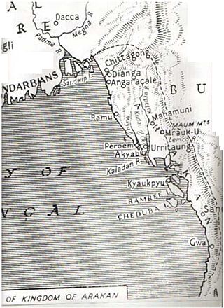
The Kingdom of Mrauk-U was a kingdom that existed on the Arakan littoral from 1429 to 1785. Based in the capital Mrauk-U, near the eastern coast of the Bay of Bengal, the kingdom ruled over what is now Rakhine State, Myanmar and southern part of Chittagong Division, Bangladesh. Though started out as a protectorate of the Bengal Sultanate from 1429 to 1531, Mrauk-U went on to conquer Chittagong with the help of the Portuguese. It twice fended off the Toungoo Burma's attempts to conquer the kingdom in 1546–1547, and 1580–1581. At its height of power, it briefly controlled the Bay of Bengal coastline from the Sundarbans to the Gulf of Martaban from 1599 to 1603. In 1666, it lost control of Chittagong after a war with the Mughal Empire. Its reign continued until 1785, when it was conquered by the Konbaung dynasty of Burma.
Mirza Ibrahim Beg, later known as Ibrahim Khan Fath-i-Jang was the Subahdar of Bengal during the reign of Mughal emperor Jahangir. He was the brother to Empress Nur Jahan.
Mukarram Khān Chishtī was the Subahdar of Bengal during the reign of Mughal emperor Jahangir from 1626 to 1627. Prior to this, he had served as the Thanadar of Bhawal, governor of Koch Hajo, Sardar of Sylhet and Subahdar of Orissa.
Min Bin was a king of Arakan from 1531 to 1554, "whose reign witnessed the country's emergence as a major power". Aided by Portuguese mercenaries and their firearms, his powerful navy and army pushed the boundaries of the kingdom deep into Bengal, where coins bearing his name and styling him sultan were struck, and even interfered in the affairs of mainland Burma.

The city of Chattogram (Chittagong) is traditionally centred around its seaport which has existed since the 4th century BCE. One of the world's oldest ports with a functional natural harbor for centuries, Chittagong appeared on ancient Greek and Roman maps, including on Ptolemy's world map. Chittagong port is the oldest and largest natural seaport and the busiest port of Bay of Bengal. It was located on the southern branch of the Silk Road. The city was home to the ancient independent Buddhist kingdoms of Bengal like Samatata and Harikela. It later fell under of the rule of the Gupta Empire, the Gauda Kingdom, the Pala Empire, the Chandra Dynasty, the Sena Dynasty and the Deva Dynasty of eastern Bengal. Arab Muslims traded with the port from as early as the 9th century. Historian Lama Taranath is of the view that the Buddhist king Gopichandra had his capital at Chittagong in the 10th century. According to Tibetan tradition, this century marked the birth of Tantric Buddhism in the region. The region has been explored by numerous historic travellers, most notably Ibn Battuta of Morocco who visited in the 14th century. During this time, the region was conquered and incorporated into the independent Sonargaon Sultanate by Fakhruddin Mubarak Shah in 1340 AD. Sultan Ghiyasuddin Azam Shah constructed a highway from Chittagong to Chandpur and ordered the construction of many lavish mosques and tombs. After the defeat of the Sultan of Bengal Ghiyasuddin Mahmud Shah in the hands of Sher Shah Suri in 1538, the Arakanese Kingdom of Mrauk U managed to regain Chittagong. From this time onward, until its conquest by the Mughal Empire, the region was under the control of the Portuguese and the Magh pirates for 128 years.
Min Khamaung also known as Hussein Shah; was the king of Arakan from 1612 to 1622.

Chittagong, the second largest city and main port of Bangladesh, was home to a thriving trading post of the Portuguese Empire in the East in the 16th and 17th centuries. The Portuguese first arrived in Chittagong around 1528, and left in 1666 after the Mughal conquest. It was the first European colonial enclave in the historic region of Bengal.

Arakan is the historical geographical name of Rakhine State, Myanmar. The region was called Arakan for centuries until the Burmese military junta changed its name in 1989. The people of the region were known as Arakanese.
Yashodhar Manikya, also known as Jashodhar Manikya, was the Maharaja of Tripura from 1600 to 1618. His reign is considered to be the nadir of the kingdom's history, with the temporary overthrowing of the monarchy and the region's incorporation into the Mughal Empire.

Rajdhar Manikya I, also spelt Rajadhara Manikya, was the Maharaja of Tripura from 1586 to 1600. Formerly a warrior-prince who fought with distinction during his father's reign, upon his own ascension to the throne, Rajdhar showed little interest in such matters, instead becoming occupied with religious pursuits. The decline of Tripura is thought to have begun during his reign.
The Greater Noakhali district region predominantly includes the districts of Noakhali, Feni and Lakshmipur, although historically included the island of Sandwip in Bay of Bengal. The history of the undivided Noakhali district region begins with the existence of civilisation in the villages of Shilua and Bhulua. Bhulua became a focal point of Bengal during the Buddhist and Hindu kingdoms of Pundra, Harikela and Samatata leading it to become the initial name of the region as a whole. The medieval Kingdom of Bhulua enjoyed autonomy under the Twipra Kingdom and Bengal Sultanate before being conquered by the Mughal Empire. At the beginning of the 17th century, Portuguese pirates led by Sebastian Gonzales took control of the ara but were later defeated by Governor Shaista Khan. Affected by floodwaters, the capital of the region was swiftly moved to a new place known as Noakhali, from which the region presently takes its name. By 1756, the British East India Company had dominated and started to establish several factories in the region. The headquarters was once again moved in 1951, to Maijdee, as a result of Noakhali town vanishing due to fluvial erosion.

Shaykh ʿAbdul Wāḥid was a military general of the Mughal Empire during the reign of Jahangir, and played an important role in defeating Bahadur Ghazi, who was among the rebellious Baro-Bhuiyans of Bengal. He is celebrated as the Mughal conqueror of Bhulua as he was the chief commander of its expedition. His administration of the Bhulua frontier involved suppressing multiple Arakanese invasions, later earning him the title of Sarḥad Khān.
The Kingdom of Bhulua was a medieval kingdom of Bengal and later a zamindari, covering the present-day Noakhali region of Bangladesh. According to local tradition the establishment of the kingdom dates from the thirteenth century, when Bishwambhar Sur, ninth son of Adi Sur, a Kshatriya of Mithila who passed by the area during a pilgrimage. There are several versions of this tale and questions about the accuracy of the date, but most probably the early Rajas of Bhulua were Kayasthas from Western Bengal. The kingdom fell under Tripura vassalage in the 15th century, and was reduced to a zamindari (fiefdom) after losing to the Mughals. Most of the kingdom's land has been eroded by the Meghna River.
The Conquest of Bhulua refers to the 17th-century Mughal conquest of the Bhulua Kingdom, which covered much of the present-day Noakhali region of Bangladesh. The campaign was led by Shaykh Abdul Wahid, under the orders of Islam Khan I, against Raja Ananta Manikya in 1613. The conquest of Bhulua allowed the Mughals to successfully penetrate through southeastern Bengal and conquer Chittagong and parts of Arakan.

Mughal conquest of Chittagong refers to the conquest of Chittagong in 1666. On 27 January 1666 AD, the Arakan Kingdom of Mrauk U was defeated by the Mughal forces under the command of Buzurg Ummed Khan, the son of Mughal Subedar Shaista Khan.
