Qaya | |
|---|---|
 Qaya | |
| Coordinates: 40°26′37″N50°16′40″E / 40.44361°N 50.27778°E | |
| Country | |
| City | Baku |
| Time zone | UTC+4 (AZT) |
| • Summer (DST) | UTC+5 (AZT) |
Qaya (also Apsheronskiy Port and Port Apsheronskiy) is a village in Baku, Azerbaijan.
Qaya | |
|---|---|
| Qaya | |
| Coordinates: 40°26′37″N50°16′40″E / 40.44361°N 50.27778°E | |
| Country | |
| City | Baku |
| Time zone | UTC+4 (AZT) |
| • Summer (DST) | UTC+5 (AZT) |
Qaya (also Apsheronskiy Port and Port Apsheronskiy) is a village in Baku, Azerbaijan.
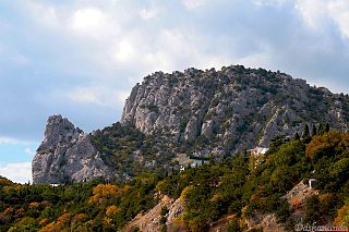
Mount Koshka is a mountain in the Crimean Mountains near the settlement of Simeiz within the Greater Yalta metropolitan area. The original name in the Crimean Tatar language means "double rock", while the Russian name means "cat", as the shape of the mountain resembles a lying cat. The height is 254 metres.
Jaya Simhavarman III, Chế Mân (制旻), or Prince Harijit, son of King Indravarman V and Queen Gaurendraksmi, was a king of Champa during a time when the threat of the Mongols was imminent. He held the title the half-king/junior king (arddharāja) on behalf of his father.
Dalıqaya is a village in the Quba Rayon of Azerbaijan. The village forms part of the municipality of Zıxır.

Sugabala or Sügebala was an empress consort of the Yuan dynasty, married to Gegeen Khan.
Yarti Qaya is a village in Bagheli-ye Marama Rural District, in the Central District of Gonbad-e Qabus County, Golestan Province, Iran. At the 2006 census, its population was 789, in 173 families.

Peak Pobeda is a mountain in Sakha Republic, Russia.
Gowjeh Qia is a village in Mojezat Rural District, in the Central District of Zanjan County, Zanjan Province, Iran. At the 2006 census, its population was 544, in 125 families.
Howmeh Rural District is in Do Tappeh District of Khodabandeh County, Zanjan province, Iran. Its capital is the village of Aqcheh Qaya.
Galin Qayah is a village in, and the capital of, Harzandat-e Gharbi Rural District of the Central District of Marand County, East Azerbaijan province, Iran. The people of Galin Qayah speak the Harzandi dialect of the Tati language.
Qareh Qayeh is a village in Garmeh-ye Shomali Rural District, Kandovan District, Meyaneh County, East Azerbaijan Province, Iran. At the 2006 census, its population was 100, in 24 families.
Qarajeh Qaya is a village in Owch Tappeh-ye Sharqi Rural District, in the Central District of Meyaneh County, East Azerbaijan Province, Iran. At the 2006 census, its population was 112, in 25 families.
Qiasi is a village in Qarah Quyun-e Jonubi Rural District, Qarah Quyun District, Showt County, West Azerbaijan Province, Iran. At the 2006 census, its population was 256, in 47 families.
Jabir Novruz was an Azerbaijani and Soviet poet, translator, editor, and secretary of the Union of Azerbaijani Writers for three decades. Considered one of the most prominent authors of modern Azerbaijani poetry, his work is known for a romantic style that inspired patriotism. He was active in bringing important national issues to the attention of his fellow citizens, and was elected to the National Assembly in 1995. Through his translations, Novruz brought world poetry to the people of Azerbaijan, and his own works have been translated and published in other languages and have also been used as lyrics in many popular Azerbaijani songs.
Nabi Alekber oghlu Babayev, better known as Nabi Khazri, was an Azerbaijani poet, playwright, publicist, translator and screenwriter.

Aq Qaya — is a rock in Crimea, situated near the village of Belaya Skala/Ak-Kaya of the Bilohirsk Raion.
Otlu Qaya is a cliff situated in the southeast of Crimea in a valley between Koktebel and Otuzy, north of Kara Dag Mountain. The height of the cliff is 263 meters above sea level. Rock name was coined from Crimean Tatar and can be translate as "grassy" or "fire rock". The rock has a through hole. Once upon a time, stones were scattered on the mountain slope that reminded a grazing flock of sheep, that stones were used in building the highway, but locals still call this area a "petrified herd". A lot of folk legends are associated with this rock, according to one of them, a young shepherd, grazing sheep on a rock, once noticed a half-naked girl and, “having forgotten the duty of hospitality, rushed to her with an unkind thought”, was immediately dumbfounded, and with him everything herd.
The Al-Tammuz missile was an Iraqi project to design a surface-to-surface missile (SSM) based on scud technology that could deliver a payload of at least 1,000 kg to a distance of 1,200 km. The missile was a potential delivery system that could have helped Iraq to deliver nuclear payloads.
Sevil Magsud gizi Hajiyeva was an Azerbaijani singer and lead vocalist of the music groups Karvan and Qaya.

Lian Xixian, born Hindu was an Uyghur politician, general and advisor to Kublai Khan, eventually rising to a position of vice-chancellor of Yuan Empire. His courtesy name was Shanfu and art name was Yeyun. An influential Confucian scholar, he was sometimes remembered as Lian Mencius in comparison with Confucian philosopher Mencius.
Sewinch Qaya or Guàn Yúnshí, art name Chengzhai, later Suanzhai was an Uyghur scholar, songwriter and a famous sanqu and shi author lived in Mongol Empire.
| | This Baku location article is a stub. You can help Wikipedia by expanding it. |
