
The Liard River of the North American boreal forest flows through Yukon, British Columbia and the Northwest Territories, Canada. Rising in the Saint Cyr Range of the Pelly Mountains in southeastern Yukon, it flows 1,115 kilometres (693 mi) southeast through British Columbia, marking the northern end of the Rocky Mountains and then curving northeast back into Yukon and Northwest Territories, draining into the Mackenzie River at Fort Simpson, Northwest Territories. The river drains approximately 277,100 square kilometres (107,000 sq mi) of boreal forest and muskeg.

The Yentna River is a river in South Central Alaska, formed by its East Fork and West Fork at 62°16′50″N151°46′26″W, flows South-East to Susitna River, 30 miles (48 km) North-West of Anchorage, Alaska; Cook Inlet Low.
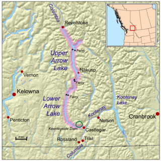
Erie Creek Provincial Park is a provincial park in British Columbia, Canada. It is a protected area because of the wildlife it hosts.
West Arm Provincial Park is a provincial park in British Columbia, Canada.
Syringa Park is a provincial park on the east shore of Lower Arrow Lake in the West Kootenay region of southeastern British Columbia. At the foot of the Norns Range, Tulip Creek passes through the centre, and Syringa Creek is closer to the southeastern boundary. The park is about 19 kilometres (12 mi) west of Castlegar via Broadwater Rd.
The Wild Horse River, formerly known as Wild Horse Creek, is a tributary of the Kootenay River, joining it near the town of Fort Steele, British Columbia, Canada. The river's canyon was the setting for the Wild Horse Creek Gold Rush and associated "war" during the gold rush of the mid-1860s.

Burton is a settlement on the east shore of Lower Arrow Lake in the West Kootenay region of southeastern British Columbia.

Gold Rush is a reality television series that airs on Discovery and its affiliates worldwide. The series follows the placer gold mining efforts of various family-run mining companies, mostly in the Klondike region of Dawson City, Yukon, Canada. In its 11th season as of early 2020, prior seasons also included mining efforts in South America and western North America.
Granite Creek is a creek and townsite in British Columbia located in the Similkameen region. Granite Creek flows north into the Tulameen River and joins that river approximately one and a half miles to the east of Coalmont, British Columbia. It is assumed Granite Creek yielded more than $500,000 in placer gold since its discovery. Gold nuggets worth $50 in value were not unusual in the early years. The creek was mined by Europeans and Chinese. Granite Creek was hydraulicked near its mouth in the 1890s.
Siwash Creek is a creek which is located in the Similkameen region of British Columbia. The creek flows into Hayes Creek approximately 3 miles (4.8 km) west of Jellicoe and 20 miles (32 km) northeast of Princeton, British Columbia. Siwash Creek has been mined for gold. The word is considered by some to be derisive, but remains in use in certain place names and other contexts without derogatory associations such as Siwash sweater. Nashwito Creek has also been referred to as Siwash Creek.
Boundary Creek is a tributary of the Kettle River in the Boundary Country region of south central British Columbia. The creek is approximately 32 kilometres (20 mi) in length, flowing from the northeast, passing east of Midway, and only the final one-quarter mile (0.40 km) is in northeastern Washington, US.
Jolly Creek is a creek located in the Boundary Country region of British Columbia. The creek is south of Conkle Lake. Jolly Creek flows into Rock Creek. It was discovered in 1860 and has been mined for gold. The Creek was named after local prospector Jolly Jack Thornton.
Erie Creek is a creek located in the West Kootenay region of British Columbia. The creek flows into the Salmo River. It was discovered in the 1860s. Erie Creek was originally called North Fork Creek. The creek was mined for gold.
Lardeau Creek is a creek located in the West Kootenay region of British Columbia. The creek flows into the head of Trout Lake. Gold was discovered prior to 1900. Lardeau Creek has been mined since its discovery. The creek has been mined using several methods, including hydraulicking.
Rover Creek is a creek in the West Kootenay Region of British Columbia. The creek is located west of Forty Nine Creek and flows into the Kootenay River. The creek has been mined for gold.
Carpenter Creek is a creek in the West Kootenay region of British Columbia. The creek flows straight through the town of Sandon.
Spruce Creek is located in the Atlin Country region of British Columbia. The creek flows into Pine Creek. Fred Marius discovered gold in this creek in 1898. In 1899 two American prospectors named West and Hoffenen found a gold nugget which weighed just over 83 ounces. The nugget was nicknamed "the west". "The west" nugget contained some quartz and thus was not the largest solid gold nugget found in British Columbia. The creek produced over 300,000 fine ounces of gold, valued at $7,000,000.
Vital Creek is a creek located in the Omineca Country region of British Columbia, flowing eastward from its source in the Vital Range to meet Silver Creek, joining that creek from the west about 5 miles from its mouth into the Omineca River, about 41 km northeast of Takla Landing.
Champion Creek is a ghost town located in the West Kootenay region of British Columbia. It is a former Doukhobor settlement. The town is near Champion Creek on the east side of Columbia River, between Trail and Castlegar.
Lemon Creek is an unincorporated community on the east side of the Slocan River in the West Kootenay region of southeastern British Columbia. The locality is on BC Highway 6 about 8 kilometres (5 mi) south of Slocan, and 62 kilometres (39 mi) north of Castlegar.
