Last updated • 7 min readFrom Wikipedia, The Free Encyclopedia
You can help expand this article with text translated from the corresponding article in French. (November 2023)Click [show] for important translation instructions.
Machine translation, like DeepL or Google Translate, is a useful starting point for translations, but translators must revise errors as necessary and confirm that the translation is accurate, rather than simply copy-pasting machine-translated text into the English Wikipedia.
Consider adding a topic to this template: there are already 1,395 articles in the main category, and specifying|topic= will aid in categorization.
Do not translate text that appears unreliable or low-quality. If possible, verify the text with references provided in the foreign-language article.
You must provide copyright attribution in the edit summary accompanying your translation by providing an interlanguage link to the source of your translation. A model attribution edit summary is Content in this edit is translated from the existing French Wikipedia article at [[:fr:Quatre-Vallées]]; see its history for attribution.
You may also add the template {{Translated|fr|Quatre-Vallées}} to the talk page.
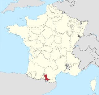
Quatre-Vallées (French pronunciation:[katʁvale], literally, "Four Valleys") (Gascon: Quate-Vaths) was a small province of France located in the southwest of France. It was made up of four constituent parts: Aure valley (Gascon: Aura), Barousse valley (Gascon: Varossa), Magnoac valley (Gascon: Manhoac), and Neste or Nestès valley (Gascon: Nèsta or Nestés).[1][2]
The Aure and Barousse valleys are contiguous. The Neste valley is also contiguous with Barousse and Aure, but most of the Neste valley was under the jurisdiction of Gascony and Comminges, and there were only two small enclaves in the Neste Valley that were part of the Quatre-Vallées province, these two enclaves being surrounded by villages under the jurisdiction of Gascony and Comminges, and physically separated from the Aure and Barousse valleys. The Aure, Barousse, and Neste valleys are all located in the Pyrenees mountains, in the southeast of the present-day département of Hautes-Pyrénées.
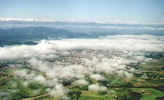
The Magnoac valley is located further north in the hilly countryside of Gascony, and is now the northeast of Hautes-Pyrénées. Magnoac was separated from Aure and Barousse by 19km.(12 miles) of land not part of Quatre-Vallées.
Thus, the Quatre-Vallée province was altogether made up of four geographically detached parts, from south to north:
Aure and Barousse valleys
Neste valley (enclave #1)
Neste valley (enclave #2)
Magnoac valley
However, politically and administratively speaking, and no matter whether contiguous or detached, the four constituent parts of the Quatre-Vallée province were, from south to north:
Quatre-Vallées had a land area of 878km2 (339 sq. miles), 58% being Aure, 22% being Magnoac, 17% being Barousse, and 3% being Neste. At the 1999 French census, there were 13,451 inhabitants on the territory of the former Quatre-Vallées province, 42% of these in Aure, 28% in Magnoac, 17% in Barousse, and 13% in Neste. The average density is thus very low for Europe, at 15 inh. per km2 (40 inh. per sq. mile), ranging from 11 inh. per km2 (28 inh. per sq. mile) in the Aure valley to 75 inh. per km2 (194 inh. per sq. mile) in the Neste valley.
There is no urban area on the territory of the former Quatre-Vallées province. In 1999 the largest villages were La Barthe-de-Neste (1,056 inhabitants) in the Neste valley and the ski resort of Saint-Lary-Soulan (1,024 inhabitants) in the Aure valley.
History
Originally part of Comminges, the valleys of Aure, Barousse, Neste, and Magnoac were detached from Comminges in the 11th century and were divided between the counts of Aure, vassals of the kings of Aragon, and the counts of Astarac (in Gascony). The line of the counts of Aure ended in 1242 without a male heir, and the county of Aure was inherited by the counts of Labarthe (residing in La Barthe-de-Neste), who by then possessed the three other valleys of Neste, Barousse, and Magnoac. Thus, the four valleys were unified under the counts of Labarthe, and began to be known as Quatre-Vallées. The counts of Labarthe were vassals of the kings of Aragon, and so Quatre-Vallées was part of the kingdom of Aragon.
Magnoac valley with the Pyrenees in the distance
In June 1300, Count Bernard of Labarthe granted the 53 articles of the "Statutes, Customs, and Privileges of the Country of Quatre-Vallées". These statutes, written in the native Romance language of the inhabitants, were quite ahead of their time: they granted full liberty to the inhabitants of the Quatre-Vallées, free ownership of land, free use of communal ovens, free usage of the forests, and so on, as well as the right to be ruled by consuls representing the people. All these privileges and liberties were unprecedented in rural areas of medieval Europe, and were normally found only in chartered cities. The Statutes of 1300 are the origin of the special privileges and distinct character that the Quatre-Vallées kept until the French Revolution.
The Quatre-Vallées were a buffer zone between the county of Comminges and the powerful county of Armagnac (in Gascony), and were coveted by both, until eventually in 1398 they became a possession of the counts of Armagnac. In 1462, Count Jean V of Armagnac ceded the fief of Quatre-Vallées to his incestuous sister Isabelle of Armagnac. Isabelle, who had given her fortune to charities, ended up in utter poverty, and on top of it she became paralyzed with hemiplegia. Taking advantage of her weakness, Gaston de Lyon, Lord of Bezaudun and seneschal of Toulouse, lured the poor Isabelle into selling him the Quatre-Vallées against 5,127 gold crowns (écus d'or), which he never paid, always postponing payment in the hope of a rapid death of Isabelle.
At the same time, in 1475, as the king of France obtained Roussillon from the king of Aragon, the Quatre-Vallées were officially detached from the kingdom of Aragon and entered the kingdom of France. However, they were still not part of the royal domain, and were just one of the many independent fiefs of the kingdom of France.
Eventually, the maneuvering of Gaston de Lyon alerted higher authorities. Gaston de Lyon then sent his private doctor to Isabelle, and this one saw to it that she would not live long enough to embarrass his master. In August 1476, the paralyzed and forlorn Isabelle of Armagnac, who in her youth had been promised to the king of England, died in horrible pain after drinking a potion prepared by the doctor to "cure" her. She was only 45. Gaston de Lyon immediately claimed the Quatre-Vallées. His attitude was so revolting that the duke of Alençon and the duke of Vendôme, relatives of Isabelle of Armagnac, sued Gaston de Lyon to prevent him from obtaining the Quatre-Vallées. The trial lasted for more than a century. At last, ruined and discouraged, the descendants of Gaston de Lyon ceded the Quatre-Vallées to Henry III of Navarre, who owned many Pyrenean fiefs (Béarn, Lower Navarre, Bigorre, County of Foix, Nébouzan).
Barousse valley
In 1589, Henry III of Navarre became king Henry IV of France. In 1607, he united to the French crown those of his personal fiefs that were under French sovereignty (i.e. County of Foix, Bigorre, Quatre-Vallée, and Nébouzan, but not Béarn and Lower Navarre, which were sovereign countries outside of the kingdom of France), and so Quatre-Vallées became part of the royal domain. Nonetheless, Quatre-Vallées kept all its privileges granted in the Middle Ages, and it also kept its provincial states until the French Revolution, which decided freely what was the level of taxation and how much was given to the king. The provincial states of Quatre-Vallées, made up of only ten members, met once a year in an inn at Garaison, a famous pilgrimage center where the Virgin Mary was said to have appeared in the beginning of the 16th century. Garaison is located in the commune of Monléon-Magnoac, in the Magnoac valley. However, Arreau, the capital of the Aure valley, is often considered by local people to be the capital of Quatre-Vallées.
At the start of the French Revolution, the Quatre-Vallées remained quiet. They had been freed and exempted from feudal taxes and corvées for centuries already, and so they did not demand equality and the end of privileges like the other parts of France did. At first it was planned that Quatre-Vallées would gather with the provinces of Nébouzan and Comminges, and that the three would elect common representatives to the Estates-General in Versailles. The Quatre-Vallées saw this as a breach of their Statutes and autonomy, and they sent a letter of protest to Versailles. Eventually, they were allowed to send their own representative to the Estates-General. This representative was assigned the task of preserving the privileges of the Quatre-Vallées at all cost. However, there was not much he could do when feudalism and all the privileges were abolished by the French National Constituent Assembly in the night of 4 August 1789, and so the Quatre-Vallées lost their old privileges.
Aure valley
In 1790, when the départements were created, the Quatre-Vallées were too small to become a département, and against the wishes of their inhabitants, who wished to join with Comminges and Nébouzan to form a département, the Quatre-Vallées were joined with Bigorre, as well as with a fragment of Nébouzan and parts of Gascony, to form the département of Hautes-Pyrénées. The people of Quatre-Vallées objected bitterly, stressing the old historical and economic ties with Comminges, but it was to no avail. After that, the people of the Quatre-Vallées returned to their isolated and self-supporting lifestyle, away from the new trends and political changes that France experienced in the 19th century.
The area remained very traditional well into the 20th century, and modernity progressed only slowly. Like the rest of the Pyrenees, Quatre-Vallées suffered a lot from rural exodus. Today, the low population density of the Quatre-Vallées have turned them into a haven for nature lovers and people wishing to discover some of the wildest parts of the Pyrenees, where a spectacular landscape is combined with a rich historical heritage and many old monuments.
Related Research Articles
Midi-Pyrénées is a former administrative region of France. Since 1 January 2016, it has been part of the new region of Occitania. It was the largest region of Metropolitan France by area, larger than the Netherlands or Denmark.
The County of Armagnac, situated between the Adour and Garonne rivers in the lower foothills of the Pyrenées, was a historic county of the Duchy of Gascony, established in 601 in Aquitaine. In 960, the title of 'Count of Armagnac' was established, and thus the County of Armagnac was created. In 1751, following the death of childless Charles de Lorraine, Comte d'Armagnac, the county was absorbed into the Crown lands of France and the King, then Louis XV took the title of 'Count of Armagnac'. In 1791, following the decree dividing France into departments, the county was disestablished, but remains an important natural region of France.
The following is a list of the 469 communes of the Hautes-Pyrénées department of France.
Lower Navarre is a traditional region of the present-day French département of Pyrénées-Atlantiques. It corresponds to the northernmost merindad of the Kingdom of Navarre during the Middle Ages. After the Spanish conquest of Iberian Navarre (1512–24), this merindad was restored to the rule of the native king, Henry II. Its capitals were Saint-Jean-Pied-de-Port and Saint-Palais. In the extreme north there was the little sovereign Principality of Bidache, with an area of 1,284 km2 (496 sq mi) and a decreasing population of 44,450, 25,356.
The County of Foix was a medieval fief in southern France, and later a province of France, whose territory corresponded roughly the eastern part of the modern département of Ariège.
Bigorre is a region in southwest France, historically an independent county and later a French province, located in the upper watershed of the Adour, on the northern slopes of the Pyrenees, part of the larger region known as Gascony. Today Bigorre comprises the centre and west of the département of Hautes-Pyrénées, with two small exclaves in the neighbouring Pyrénées Atlantiques. Its inhabitants are called Bigourdans.
The Comminges is an ancient region of southern France in the foothills of the Pyrenees, corresponding approximately to the arrondissement of Saint-Gaudens in the department of Haute-Garonne. This region is normally associated with the former domain of the Counts of Comminges, although earlier definitions are based on the Diocese of Comminges or the territory of the Convenae.
Nébouzan was a small province of France located in the foothills of the Pyrenees mountains, in the southwest of France. It was not a contiguous province, but it was made up of several detached territories, approximately half of them around the town of Saint-Gaudens in the south of the present-day département of Haute-Garonne, and the other half around the town of Lannemezan in the east of the present-day département of Hautes-Pyrénées. The capital of Nébouzan was Saint-Gaudens.
The Aquitani were a tribe that lived in the region between the Pyrenees, the Atlantic Ocean, and the Garonne, in present-day southwestern France in the 1st century BC. The Romans dubbed this region Gallia Aquitania. Classical authors such as Julius Caesar and Strabo clearly distinguish the Aquitani from the other peoples of Gaul, and note their similarity to others in the Iberian Peninsula.
The following is a list of the 17 cantons of the Hautes-Pyrénées department, in France, following the French canton reorganisation which came into effect in March 2015:
Gaston IV was the sovereign Viscount of Béarn and the Count of Foix and Bigorre in France from 1436 to 1472. He also held the viscounties of Marsan, Castelbon, Nébouzan, Villemeur and Lautrec and was, by virtue of the county of Foix, co-prince of Andorra. From 1447 he was also Viscount of Narbonne. Through his marriage to Eleanor, heiress of the Kingdom of Navarre, he also held the title of Prince of Navarre.
The viscounts of Béarn were the rulers of the viscounty of Béarn, located in the Pyrenees mountains and in the plain at their feet, in southwest France. Along with the three Basque provinces of Soule, Lower Navarre, and Labourd, as well as small parts of Gascony, it forms the current département of Pyrénées-Atlantiques (64).
The Duchy of Gascony or Duchy of Vasconia was a duchy located in present-day southwestern France and northeastern Spain, an area encompassing the modern region of Gascony. The Duchy of Gascony, then known as Wasconia, was originally a Frankish march formed to hold sway over the Basques. However, the duchy went through different periods, from its early years with its distinctively Basque element to the merger in personal union with the Duchy of Aquitaine to the later period as a dependency of the Plantagenet kings of England.
Centule V, called the Young, was the Viscount of Béarn from 1058 to his death. Centule increased the autonomy of the viscounts of Béarn and distanced them from the dukes of Aquitaine, to whom they owed theoretical vassalage. Centule was also Count of Bigorre jure uxoris as Centule I.
The County of Fézensac was an 8th-century creation on the north-eastern fringes of the Duchy of Gascony following Charlemagne's policy of feudalisation and Frankish colonisation. The move was aimed at offsetting and undermining the authority of the duke of Gascony Lupo II after the setback suffered by the Franks at the Battle of Roncevaux in 778 and failure to restrain the Basques. That advance clearly displeased the Basques, with these policies sparking a stir on the banks of the Garonne.
The Viscounty, later Principalityof Béarn, was a medieval lordship in the far south of France, part of the Duchy of Gascony from the late ninth century. In 1347, the viscount declared Béarn an independent principality without feudal obligations. It later entered a personal union with the Kingdom of Navarre in 1479 and with France in 1589. In 1620, the prince formally incorporated Béarn as a province of France.
John IV was a Count of Armagnac, Fézensac, and Rodez from 1418 to 1450. He was involved in the intrigues related to the Hundred Years' War and in conflicts against the King of France.
The Battle of Launac took place on 5 December 1362. It was the culmination of a long running feud between the French aristocratic families of D'Armagnac and Foix-Béarn. The chief protagonists were Jean, Comte d'Armagnac and Gaston Fébus of Foix. The result was a major victory for Gaston Fébus.
Petronilla of Bigorre or Petronilla of Comminges was ruling Countess of Bigorre between 1194 and 1251. She was the only child of Bernard IV, Count of Comminges, and his wife Stephanie-Beatrice IV, Countess of Bigorre. Petronilla succeeded her mother in 1194 as Countess of Bigorre; she was also Viscountess of Marsan and Nébouzan through further successions. She reigned as countess for fifty-seven years, in which time she was married five times.
Occitania is the southernmost administrative region of metropolitan France excluding Corsica, created on 1 January 2016 from the former regions of Languedoc-Roussillon and Midi-Pyrénées. The Council of State approved Occitania as the new name of the region on 28 September 2016, coming into effect on 30 September 2016.
This page is based on this Wikipedia article Text is available under the CC BY-SA 4.0 license; additional terms may apply. Images, videos and audio are available under their respective licenses.