The Territory of Cocos (Keeling) Islands is an Australian external territory in the Indian Ocean, comprising a small archipelago approximately midway between Australia and Sri Lanka and closer to the Indonesian island of Sumatra. It is part of Southeast Asia and is in the Southern Hemisphere. The territory's dual name reflects that the islands have historically been known as either the Cocos Islands or the Keeling Islands.
The vigesimal or base 20 numeral system is based on twenty.
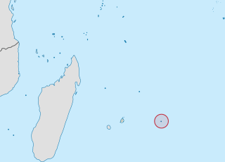
Rodrigues is a 108-square-kilometre (42 sq mi) autonomous outer island of the Republic of Mauritius in the Indian Ocean, about 560 kilometres (350 mi) east of Mauritius. It is part of the Mascarene Islands which include Mauritius and Réunion. It is of volcanic origin and is surrounded by coral reef, and just off its coast lie some tiny uninhabited islands. The island used to be the tenth District of Mauritius; it gained autonomous status on 10 December 2002, and it is governed by the Rodrigues Regional Assembly. The capital of the island is Port Mathurin.
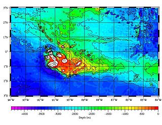
Saint Brandon, also known as the Cargados Carajos Shoals, is an Indian Ocean archipelago about 430 kilometres (270 mi) northeast of Mauritius consisting of a number of sand banks, shoals and islets. Saint Brandon consists of five island groups, with about 28–40 islands and islets in total, depending on seasonal storms and related sand movements. There are 22 named islands and shoals. The archipelago is low-lying and is prone to substantial submersion in severe weather. It has an aggregate land area estimated variously at 1.3 km2 (0.50 sq mi) and 500 acres (2.0 km2). Economic activity in the region is limited to fishing on the very extensive shallow bank covering approximately 900 sq mi (2,300 km2) around the islands. By the early 19th century, most of the islands were in use as fishing stations. Geographically, the archipelago is part of the Mascarene Islands and is situated on the Mascarene Plateau formed by the separation of the Mauritia microcontinent during the separation of India and Madagascar about 60 million years ago.

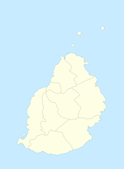
The Districts of the Republic of Mauritius are the second-order administrative divisions after the Outer islands of the country. Mauritius is divided into nine districts which consist of 1 city, 4 towns and 130 villages, the capital is Port Louis.

Quatre Bornes also known as La Ville des Fleurs, is a town in Mauritius, located in the Plaines Wilhems District, the western part also lies in the Rivière Noire District. The town is administered by the Municipal Council of Quatre Bornes. Situated between the towns of Beau-Bassin Rose-Hill and Vacoas-Phoenix, Quatre Bornes is linked by roads to the north, east, south and west of Mauritius. According to the census made by Statistics Mauritius in 2015, the population of the town was at 77,505.

Plaines Wilhems is a district of Mauritius. It is the most populous district, with its population estimated at 368,621 as of 31 December 2015. The district is mainly urban; it consists of four towns, the village of Midlands and part of two other villages. The Plaines Wilhems district does not have a District Council; it has four Municipal Town Councils. The towns are Beau-Bassin Rose-Hill, Curepipe, Quatre Bornes and Vacoas-Phoenix. The villages are Midlands, Cascavelle and Moka. The district was named after Wilhem Leicknig. Of Prussian origin, he settled on the island of Mauritius, then known as Isle de France, in 1721.
Island(s) called Cocos or Coco include the following:
The Mauritius national rugby union team represents Mauritius in international rugby union. Mauritius is a member of the International Rugby Board (IRB), but the national team is ranked as third tier, and Mauritius have yet to compete in either the Africa Cup or Rugby World Cup.

Rivière Noire or Black River is a district on the western side of the island of Mauritius. Rivière Noire translates to Black River. This region receives less rainfall than the others. The district has an area of 259 square kilometres (100 sq mi) and the population estimate was 80,939 as of 31 December 2015. It is the third largest District of Mauritius in area, but the smallest in terms of population. The district is mostly rural, but it also include the western part of the city of Port Louis and western part of Quatre Bornes.
The Islets of Mauritius includes nearly a hundred tiny islets and rocks scattered around the coast of Mauritius as well as Rodrigues.
The Galápagos hotspot is a volcanic hotspot in the East Pacific Ocean responsible for the creation of the Galapagos Islands as well as three major aseismic ridge systems, Carnegie, Cocos and Malpelo which are on two tectonic plates. The hotspot is located near the Equator on the Nazca Plate not far from the divergent plate boundary with the Cocos Plate. The tectonic setting of the hotspot is complicated by the Galapagos Triple Junction of the Nazca and Cocos plates with the Pacific Plate. The movement of the plates over the hotspot is determined not solely by the spreading along the ridge but also by the relative motion between the Pacific Plate and the Cocos and Nazca Plates.

The following outline is provided as an overview of and topical guide to Mauritius:
Antoine Zacharie Adrien d'Épinay in Paris. He was the son of Antoine Jean Caiez d’Épinay and Marie Marthe Blanc. Adrien d'Épinay was a lawyer and politician from Mauritius who at the beginning of the 19th century helped found the Société royale des Arts et des Sciences de l'île Maurice, the Bank of Mauritius and the first independent and daily newspaper in Mauritius, Le Cernéen, after the Portuguese name for the island. He started his career at the bar in Port Louis in 1816.
Association Sportive Quatre Bornes is a Mauritian football club based in Quatre Bornes, Plaines Wilhems District. In 2017–18, they play in Mauritian League.
The following is an index of Mauritius-related topics by alphabetical order.
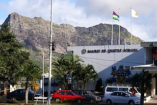
The Municipal Council of Quatre Bornes also known as Municipality is the local authority responsible for the administration of the town of Quatre Bornes, Plaines Wilhems District, Mauritius. The actual Mayor is Mr SONOO Atmaram and the Deputy Mayor is Mrs KOENIG Arline.
Quatre Bornes State Secondary School (QBSSS) is a government-operated secondary school in Quatre Bornes, Mauritius.