
Pseudotsuga is a genus of evergreen coniferous trees in the family Pinaceae.

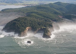
Olympic National Park is a United States national park located in the State of Washington, on the Olympic Peninsula. The park has four regions: the Pacific coastline, alpine areas, the west-side temperate rainforest, and the forests of the drier east side. Within the park there are three distinct ecosystems, including subalpine forest and wildflower meadow, temperate forest, and the rugged Pacific coast.
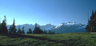
The Olympic Mountains are a mountain range on the Olympic Peninsula of the Pacific Northwest of the United States. The mountains, part of the Pacific Coast Ranges, are not especially high – Mount Olympus is the highest at 7,965 ft (2,428 m); however, the eastern slopes rise out of Puget Sound from sea level and the western slopes are separated from the Pacific Ocean by the low-lying 20 to 35 km wide Pacific Ocean coastal plain. The western slopes are the wettest place in the 48 contiguous states. Most of the mountains are protected within the bounds of Olympic National Park and adjoining segments of the Olympic National Forest.

Thuja plicata is an evergreen coniferous tree in the cypress family Cupressaceae, native to western North America. Its common name is western redcedar, and it is also called Pacific redcedar, giant arborvitae, western arborvitae, just cedar, giant cedar, or shinglewood. It is not a true cedar of the genus Cedrus.

The Olympic Peninsula is a large arm of land in western Washington that lies across Puget Sound from Seattle, and contains Olympic National Park. It is bounded on the west by the Pacific Ocean, the north by the Strait of Juan de Fuca, and the east by Hood Canal. Cape Alava, the westernmost point in the contiguous United States, and Cape Flattery, the northwesternmost point, are on the peninsula. Comprising about 3,600 square miles (9,300 km2), the Olympic Peninsula contained many of the last unexplored places in the contiguous United States. It remained largely unmapped until Arthur Dodwell and Theodore Rixon mapped most of its topography and timber resources between 1898 and 1900.

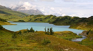
Lake Quinault is a lake on the Olympic Peninsula in western Washington state. It is located in the glacial-carved Quinault Valley of the Quinault River, at the southern edge of Olympic National Park in the northwestern United States. One of the most dominant features of Lake Quinault is its location within the Quinault Rainforest, a temperate rain forest.

Temperate rainforests are coniferous or broadleaf forests that occur in the temperate zone and receive heavy rain.

The Pacific temperate rainforests of western North America is the largest temperate rain forest region on the planet as defined by the World Wildlife Fund. The Pacific temperate rainforests lie along the western side of the Pacific Coast Ranges along the Pacific Northwest Coast of North America from the Prince William Sound in Alaska through the British Columbia Coast to Northern California, and are part of the Nearctic realm, as also defined by the World Wildlife Fund. The Pacific temperate rain forests are characterized by a high amount of rainfall, in some areas more than 300 cm (10 ft) per year and moderate temperatures in both the summer and winter months.

The Hoh River is a river of the Pacific Northwest, located on the Olympic Peninsula in the U.S. state of Washington. About 56 miles (90 km) long, the Hoh River originates at the Hoh Glacier on Mount Olympus and flows west through the Olympic Mountains of Olympic National Park and Olympic National Forest, then through the foothills in a broad valley, emptying into the Pacific Ocean at the Hoh Indian Reservation. The final portion of the Hoh River's course marks the boundary between the coastal segment of Olympic National Park and Olympic National Forest, the Hoh Indian Reservation.

Mount Revelstoke National Park is a national park located adjacent to the city of Revelstoke, British Columbia, Canada. The park is relatively small for a national park, covering 260 km2 (100 sq mi). It is located in the Selkirk Mountains and was founded in 1914. Approximately 600,000 visitors enter Mount Revelstoke and nearby Glacier National Park each year.
The Chugach National Forest is a 6,908,540-acre (27,958 km2) United States National Forest in south central Alaska. Covering portions of Prince William Sound, the Kenai Peninsula and the Copper River Delta, it was formed in 1907 from part of a larger forest reserve. The Chugach includes extensive shorelines, glaciers, forests and rivers, much of which is untouched by roads or trails. It hosts numerous bird, mammal and marine species, including extensive shorebird habitat and a bald eagle population larger than the contiguous 48 states combined. Human industry in the forest includes extensive tourism and some mining and oil and gas operations.
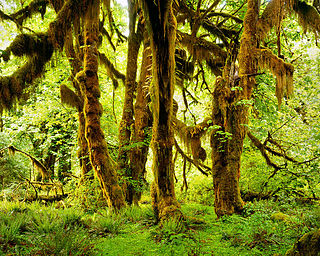
Hoh Rainforest is one of the largest temperate rainforests in the U.S., located on the Olympic Peninsula in western Washington state. It includes 24 miles (39 km) of low elevation forest 394 to 2,493 feet along the Hoh River. The Hoh River valley was formed thousands of years ago by glaciers.

Carmanah Walbran Provincial Park, originally Carmanah Pacific Provincial Park, is a remote wilderness park located inside traditional Ditidaht First Nation ancestral territory. The park covers a land area of 16,450 ha (63.5 sq mi) immediately adjacent to Pacific Rim National Park Reserve's West Coast Trail on the south-western, coastal terrain of Vancouver Island. The provincial park comprises the entire drainage of Carmanah Creek, and a good portion of the lower Walbran River drainage, both of which independently empty into the Pacific Ocean. The park is named after the Anglicized diitiid?aatx word kwaabaaduw7aa7tx, or Carmanah, meaning "thus far upstream" and John Thomas Walbran, a colonial explorer and ship's captain. Access to the park is by gravel logging road from Port Alberni, Lake Cowichan, or Port Renfrew.

The New England-Acadian forests are a temperate broadleaf and mixed forest ecoregion in North America that includes a variety of habitats on the hills, mountains and plateaus of New England and New York State in the Northeastern United States, and Quebec and the Maritime Provinces of Eastern Canada.
The Ecology of the North Cascades is heavily influenced by the high elevation and rain shadow effects of the mountain range. The North Cascades is a section of the Cascade Range from the South Fork of the Snoqualmie River in Washington, United States, to the confluence of the Thompson and Fraser Rivers in British Columbia, Canada, where the range is officially called the Cascade Mountains but is usually referred to as the Canadian Cascades. The North Cascades Ecoregion is a Level III ecoregion in the Commission for Environmental Cooperation's classification system.
The Central Pacific coastal forests is a temperate coniferous forest ecoregion located in the Canadian province of British Columbia and the U.S. states of Oregon and Washington, as defined by the World Wildlife Fund (WWF) categorization system.

The North Central Rockies forests is a temperate coniferous forest ecoregion of Canada and the United States. This region overlaps in large part with the North American inland temperate rainforest and gets more rain on average than the South Central Rockies forests and is notable for containing the only inland populations of many species from the Pacific coast.
Clayoquot Sound Biosphere Reserve is a UNESCO Biosphere Reserve situated in Clayoquot Sound on the west coast of Vancouver Island in British Columbia, Canada. A diverse range of ecosystems exist within the biosphere reserve boundaries, including temperate coastal rainforest, ocean and rocky coastal shores.

The North American inland temperate rainforest is a 7 million hectare disjunct temperate rainforest spreading over parts of British Columbia in Canada as well as Washington, Idaho and Montana on the US side. Its patches are located on the windward slopes of the Rocky Mountains and the Columbia Mountains, extending roughly over 1000km from 54° North to 45° North. It is one of the largest inland temperate and boreal rainforests in the world.
Cheewhat Giant, also known as the Cheewhat Lake Cedar, is a large western red cedar tree located within Pacific Rim National Park Reserve on Vancouver Island in British Columbia, Canada. It is the largest living Western redcedar, the largest known tree in Canada and one of the largest in the world.


