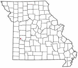
Polk County is a county located in the southwestern portion of the U.S. state of Missouri. As of the 2020 census, the population was 31,519. Its county seat is Bolivar. The county was organized January 5, 1835, and named for Ezekiel Polk. Polk County is part of the Springfield, MO Metropolitan Statistical Area.

Morgan County is a county located in the central portion of the U.S. state of Missouri. As of the 2020 census, the population was 21,006. Its county seat is Versailles. The county was organized January 5, 1833, and named for General Daniel Morgan of the American Revolutionary War.

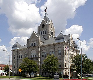
Hickory County is located in the U.S. state of Missouri. As of the 2020 census, the population was 8,279. Its county seat is Hermitage. The county was organized February 14, 1845, and named after President Andrew Jackson, whose nickname was "Old Hickory." The Pomme de Terre Dam, a Corps of Engineers facility, is located three miles south of Hermitage and forms Lake Pomme de Terre by damming the Pomme de Terre River and Lindley Creek. Truman Reservoir, also a Corps of Engineers facility, floods the Pomme de Terre Reservoir from the northern border of the county southward to the city limits of Hermitage.

Cassville is a city in Flat Creek Township, Barry County, Missouri, United States. According to the 2020 census, the population of Cassville was 3,190. Cassville is one of the primary markets and job centers for an estimated 14,000 people living in the surrounding area. It is the county seat of Barry County.

Purdy is a city in Purdy Township, Barry County, Missouri, United States, on the foothills of the Ozarks, eight miles south of Monett and twelve miles north of Cassville along Highway 37. The population was 1,098 at the 2010 census.
Cole Camp is a small city in Benton County, Missouri, United States. The population was 1,121 at the 2010 census.

Clever is a city in Christian County, Missouri, United States. The population was 2,139 at the 2010 census. It is part of the Springfield, Missouri Metropolitan Statistical Area. Clever, like the rest of Christian County, saw a significant increase in population between 2000 and 2010.

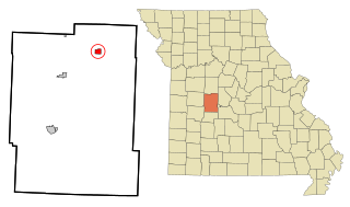
Wheatland is a city in Hickory County, Missouri, United States. The population was 277 at the 2020 census.
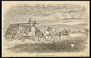
Butterfield Overland Mail was a stagecoach service in the United States operating from 1858 to 1861. It carried passengers and U.S. Mail from two eastern termini, Memphis, Tennessee, and St. Louis, Missouri, to San Francisco, California. The routes from each eastern terminus met at Fort Smith, Arkansas, and then continued through Indian Territory (Oklahoma), Texas, New Mexico, Arizona, Mexico, and California ending in San Francisco. On March 3, 1857, Congress authorized the U.S. postmaster general, at that time Aaron V. Brown, to contract for delivery of the U.S. mail from St. Louis to San Francisco. Prior to this, U.S. Mail bound for the Far West had been delivered by the San Antonio–San Diego Mail Line since June 1857.
This is a list of properties and historic districts in Arkansas that are listed on the National Register of Historic Places. There are more than 2,600 listings in the state, including at least 8 listings in each of Arkansas's 75 counties.
Taberville is an unincorporated community in southwestern St. Clair County, Missouri, United States. It is located approximately sixteen miles west of Osceola, situated on the north side of the Osage River. Taberville formerly had a post office, but it has closed and mail is now delivered from nearby Rockville.
Strickler is an unincorporated community in Cove Creek Township, Washington County, Arkansas, United States. It is located on Arkansas Highway 265, northwest of Devil's Den State Park.
The Butterfield Overland Mail in Arkansas and Missouri was created by the United States Congress on March 3, 1857, and operated until March 30, 1861. The route that was operated extended from San Francisco, California to Los Angeles, then across the Colorado Desert to Fort Yuma, then across New Mexico Territory via, Tucson and Mesilla, New Mexico to Franklin, Texas, midpoint on the route. The route then crossed Texas to the Red River and into Indian Territory to enter Arkansas at Fort Smith. Fort Smith was terminal where the secondary route that crossed Arkansas and across the Mississippi River to Memphis, Tennessee, met the main route that led northeast to Tipton with the final leg by train via the Pacific Railroad to St. Louis. The Arkansas and Missouri mail route was one division, the 8th under a superintendent.
Hogeye is an unincorporated community in Valley Township, Washington County, Arkansas, United States. It is located on Arkansas Highway 265 and Arkansas Highway 156.
Schellbourne, formerly known as Fort Schellbourne and Schell Creek Station is a ghost town located in the Schell Creek Range in White Pine County in Nevada, United States, located 43 miles (69 km) north of Ely. The town was a stopover along the Central Overland Route, Pony Express and original routing of the Lincoln Highway. It is today Nevada Historical Marker number 51. The site was listed on the National Register of Historic Places in 1972. Its boundaries were increased in 1977.

Fitzgerald Station and Farmstead is a collection of historic buildings and structures in Springdale, Arkansas associated with the Butterfield Overland Mail Trail. Historically the site of a tavern popular with travelers heading west prior to the establishment of the Butterfield Trail, the property became a station along the route in the 1850s. Today, the property retains an original 1850s barn built as a waypoint along the route, as well as an 1870s house and associated outbuildings. It was listed on the National Register of Historic Places in May 2003.

Butterfield Overland Mail Route 1858-1861 Period on a Campbell's 1873 Map by Gregory Wadley

Rondo is an unincorporated community in Polk County, in the U.S. state of Missouri.
Harper is an unincorporated community in St. Clair County, in the U.S. state of Missouri. The community is on Missouri Route 82 approximately ten miles east of Osceola and within one mile of the St. Clair - Hickory county line.
Montgomery Township is an inactive township in Hickory County, in the U.S. state of Missouri. It was named after Judge Joseph C. Montgomery.


