Related Research Articles
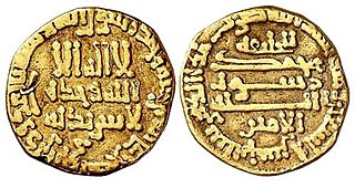
Abu Musa Muhammad ibn Harun al-Rashid, better known by his laqab of al-Amin, was the sixth Arab Abbasid caliph from 809 to 813.

Khorasan, also called Traxiane during Hellenistic and Parthian times, was a province in northeastern Iran until September 2004, when it was divided into three new provinces: North Khorasan, South Khorasan, and Razavi Khorasan.

Semnan province is one of the 31 provinces of Iran. It is in the north of the country, with its center and capital in the city of Semnan. The province of Semnan covers an area of 96,816 square kilometers and stretches along the Alborz mountain range, bordering on Kavir desert in its southern parts.

Van Province is a province and metropolitan municipality in the Eastern Anatolian region of Turkey, between Lake Van and the Iranian border. Its area is 20,921 km2, and its population is 1,128,749 (2022). Its adjacent provinces are Bitlis to the west, Siirt to the southwest, Şırnak and Hakkâri to the south, and Ağrı to the north. The capital of the province is the city of Van, with a population of 525,016 at the end of 2022. The second-largest city is Erciş, with 92,945 inhabitants at end 2022. The province is considered part of Western Armenia by Armenians and was part of ancient province of Vaspurakan. The region is considered to be the cradle of Armenian civilization. Before the Armenian genocide, Van Province was part of six Armenian vilayets. A majority of the province's modern day population is Kuresunni Azerbaijanis and Kurdish.
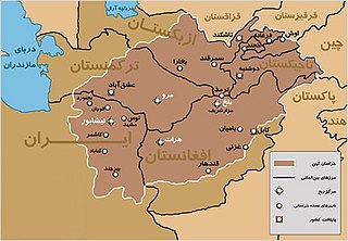
Greater Khorāsān, or Khorāsān is a historical eastern region in the Iranian Plateau between West and Central Asia.
Qumis, also known as Hecatompylos was an ancient city which was the capital of the Arsacid dynasty by 200 BCE. The Greek name Hekatompylos means "one hundred gates" and the Persian term has the same meaning. The title was commonly used for cities which had more than the traditional four gates. It may be understood better as the "Many Gated". Most scholars locate it at Sahr -e Qumis, in the Qumis region in west Khurasan, Iran.

Damghan is a city in the Central District of Damghan County, Semnan province, Iran, serving as capital of both the county and the district.

Shahrud is a city in the Central District of Shahrud County, Semnan province, Iran, serving as capital of both the county and the district.

Damghan County is in Semnan province, Iran. Its capital is the city of Damghan.
Hulwan was an ancient town on the Zagros Mountains in western Iran, located on the entrance of the Paytak Pass, nowadays identified with the town of Sarpol-e Zahab.
Dibaj is a city in the Central District of Damghan County, Semnan province, Iran.

Kordkuy is a city in the Central District of Kordkuy County, Golestan province, Iran, serving as both capital of the district and of the county. The natives of Kordkuy call their city Kard Male and speak Mazandarani.

The 856 Damghan earthquake or the 856 Qumis earthquake occurred on 22 December 856. The earthquake had an estimated magnitude of 7.9, and a maximum intensity of X (Extreme) on the Mercalli intensity scale. The meizoseismal area extended for about 350 kilometres (220 mi) along the southern edge of the eastern Alborz mountains of present-day Iran including parts of Tabaristan and Gorgan. The earthquake's epicenter is estimated to be close to the city of Damghan, which was then the capital of the Persian province of Qumis. It caused approximately 200,000 deaths and is listed by the USGS as the sixth deadliest earthquake in recorded history. This death toll has been debated.
Gerdkuh was a castle of the Nizari Isma'ili state located near Damghan in the region of Qumis.
Taq is a village in Howmeh Rural District, in the Central District of Damghan County, Semnan Province, Iran. The town is 7km from Damghan, South of Gorgan and about 200km east of Tehran, the national capital. At the 2006 census, its population was 231, in 72 families.

The Fourth Fitna or Great Abbasid Civil War resulted from the conflict between the brothers al-Amin and al-Ma'mun over the succession to the throne of the Abbasid Caliphate. Their father, Caliph Harun al-Rashid, had named al-Amin as the first successor, but had also named al-Ma'mun as the second, with Khurasan granted to him as an appanage. Later a third son, al-Qasim, had been designated as third successor. After Harun died in 809, al-Amin succeeded him in Baghdad. Encouraged by the Baghdad court, al-Amin began trying to subvert the autonomous status of Khurasan, and al-Qasim was quickly sidelined. In response, al-Ma'mun sought the support of the provincial élites of Khurasan and made moves to assert his own autonomy. As the rift between the two brothers and their respective camps widened, al-Amin declared his own son Musa as his heir and assembled a large army. In 811, al-Amin's troops marched against Khurasan, but al-Ma'mun's general Tahir ibn Husayn defeated them in the Battle of Ray, and then invaded Iraq and besieged Baghdad itself. The city fell after a year, al-Amin was executed, and al-Ma'mun became Caliph.
Ahvanu is a village in Rudbar Rural District of the Central District of Damghan County, Semnan province, Iran.
The 2010 Damghan earthquake occurred in northern Iran at 11:53:49 local time on August 27 with a moment magnitude of 5.8 and maximum Mercalli intensity of VII. This strike-slip event damaged and destroyed a number of small villages in a sparsely populated region near the Alborz mountain range. It left four people dead, 40 injured, and about 800 without homes. The deaths and injuries in this moderate event were attributed to the low-quality construction styles that are typical of the area. The Iranian Strong Motion Network provided data by which seismologists determined the type and extent of the slip as well as the peak ground acceleration. Other large and destructive earthquakes have affected Semnan Province, including several events in 856 AD and 1953.
The (Great) Khurasan Road was the great trunk road connecting Mesopotamia to the Iranian Plateau and thence to Central Asia, China, and the Indus Valley.

Two trains collided on the main line in Semnan Province between Semnan and Damghan, Iran, on 25 November 2016, resulting in 49 deaths and 103 injuries. There were reported difficulties with the rescue operation due to the incident's remote location 4 km from the nearest station, Haft-Khan, and because only one helicopter could reach the scene immediately to join the rescue operation. It was the deadliest rail disaster in Iran since the Nishapur train disaster in 2004.
References
- 1 2 3 Bosworth, C. E. (1986). The Encyclopaedia of Islam . Vol. V (New ed.). Leiden: E. J. Brill. pp. 377–378. ISBN 9004078193.
- ↑ Wiesehöfer, Josef (Kiel). "Comisene." Brill's New Pauly . Antiquity volumes edited by: Hubert Cancik and , Helmuth Schneider. Brill Online, 2015. Reference. 17 August 2015 <http://referenceworks.brillonline.com/entries/brill-s-new-pauly/comisene-e619040>
- ↑ "قومس و اسماعیلیان".