
Damghan is a city in the Central District of Damghan County, Semnan province, Iran, serving as capital of both the county and the district.

Shahrud is a city in the Central District of Shahrud County, Semnan province, Iran, serving as capital of both the county and the district.

An earthquake occurred on November 27, 2005, at 13:52 IRST on the sparsely populated Qeshm Island off Southern Iran, killing 13 people and devastating 13 villages. It was Iran's second major earthquake of 2005, following the one at Zarand in February. The epicenter was about 1,500 kilometers (930 mi) south of Tehran, close to Iran's southern borders. Initial measurements showed that the earthquake registered about 6.0 on the moment magnitude scale, although that was reduced to 5.8 after further analysis. More than 400 minor aftershocks followed the main quake, 36 of which were greater than magnitude 2.5. The earthquake occurred in a remote area during the middle of the day, limiting the number of fatalities. Iranian relief efforts were effective and largely adequate, leading the country to decline offers of support from other nations and UNICEF.
The 1909 Borujerd earthquake also known as Silakhor earthquake occurred in Silakhor plain, Persia on January 23. Around 8,000 fatalities were caused directly from the magnitude 7.3 earthquake. An indefinite number of aftershocks continued for six months after the main shock. The section on this fault ruptured was the same as the main rupture zone of the 2006 Borujerd earthquake.
The 2008 Qeshm earthquake occurred on 10 September in the Hormozgān Province of southern Iran, 850 kilometres (528 mi) south of Tehran. Its epicenter was near the port city of Bandar Abbas, where an earthquake two years prior had caused damage. The earthquake measured 5.9 on the moment magnitude scale and 6 on the surface wave scale, killing seven people and injuring up to 45. Causing both catastrophic and minor damage, the earthquake devastated up to 200 villages throughout southern Iran, but left the port city of Bandar Abbas almost unscathed. Citizens reportedly panicked when the earthquake hit, emptying into the parks of the city and other open areas.

The 1932 Ierissos earthquake occurred at 19:20 on 26 September. It caused severe damage in Ierissos, Greece and the surrounding part of the Chalkidiki peninsula, with 161–491 casualties reported.
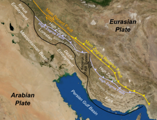
The Zagros fold and thrust belt is an approximately 1,800-kilometre (1,100 mi) long zone of deformed crustal rocks, formed in the foreland of the collision between the Arabian plate and the Eurasian plate. It is host to one of the world's largest petroleum provinces, containing about 49% of the established hydrocarbon reserves in fold and thrust belts (FTBs) and about 7% of all reserves globally.
The 1972 Qir earthquake occurred at 05:36 local time on 10 April 1972. It had a magnitude of 6.7 on the moment magnitude scale and a maximum perceived intensity of IX (Violent) on the Mercalli intensity scale. The epicentre was in the province of Fars in southern Iran. The earthquake caused the destruction of Qir and serious damage to towns and villages in the surrounding area. The estimated number of deaths is 5,374, with a further 1,710 injured.
The 1893 Quchan earthquake occurred at about 19:30 local time on 17 November. It had an estimated magnitude of 6.6 on the surface-wave magnitude scale and a maximum perceived intensity of IX (Violent) on the Mercalli intensity scale. It caused severe damage in Quchan County, particularly to the town of Quchan itself and there were an estimated 18,000 casualties.
The 2010 Damghan earthquake occurred in northern Iran at on August 27 with a moment magnitude of 5.8 and maximum Mercalli intensity of VII. This strike-slip event damaged and destroyed a number of small villages in a sparsely populated region near the Alborz mountain range. It left four people dead, 40 injured, and about 800 without homes. The deaths and injuries in this moderate event were attributed to the low-quality construction styles that are typical of the area. The Iranian Strong Motion Network provided data by which seismologists determined the type and extent of the slip as well as the peak ground acceleration. Other large and destructive earthquakes have affected Semnan Province, including several events in 856 AD and 1953.
The 1979 Ghaenat earthquakes were a series of large earthquakes in Qaen County, Khorasan province, northeast Iran, near the Afghanistan border. The first mainshock, known as the Korizan earthquake with a surface-wave magnitude (Ms ) of 6.6 and moment magnitude (Mw ) of 6.8, struck on November 14, while the Ms 7.1 or Mw 7.2 Koli-Boniabad earthquake struck on November 27. The two mainshocks were assigned a maximum Modified Mercalli intensity of VIII (Severe) and X (Extreme), respectively. The earthquakes caused extensive damage throughout northeastern Iran, killing an estimated 297 to 440 people and left at least 279 injured.
The 1997 Bojnurd earthquake occurred on 4 February at 14:07 IRST in Iran. The epicenter of the 6.5 earthquake was in the Kopet Dag mountains of North Khorasan, near the Iran–Turkmenistan border, about 579 km (360 mi) northeast of Tehran. The earthquake is characterized by shallow strike-slip faulting in a zone of active faults. Seismic activity is present as the Kopet Dag is actively accommodating tectonics through faulting. The earthquake left 88 dead, 1,948 injured, and affected 173 villages, including four which were destroyed. Damage also occurred in Shirvan and Bojnord counties. The total cost of damage was estimated to be over US$ 30 million.
The 2019 East Azerbaijan earthquake occurred at 03:17 local-time on 8 November 2019. This earthquake had a moment magnitude of 5.9 and had a shallow depth of 20 km.
The region of Ningxia was struck by a major earthquake on the morning of 14 October 1709. It had an estimated magnitude of 7.5 and a maximum felt intensity of X (extreme) on the Modified Mercalli intensity scale. The city of Zhongwei was badly damaged, including a section of the Great Wall. A total of 2,032 people were killed.

The 1641 Tabriz earthquake occurred on the night of 5 February in present-day East Azerbaijan province, Iran. The earthquake had an estimated surface-wave magnitude of 6.8 and an epicenter between Lake Urmia and the city of Tabriz. It was one of the most destructive earthquakes in the region, resulting in the loss of up to 30,000 lives.
The 1977 Bob–Tangol earthquake struck Kerman province of Iran on December 20, 1977, at 03:04 Iran Standard Time. The earthquake measured 5.9 and struck at a depth of 22.7 km (14.1 mi). A maximum Modified Mercalli intensity of VII was evaluated based on damage. It had a strike-slip focal mechanism, which was unusual as the source structure was a thrust fault. It was part of a sequence of strong earthquakes along the 400 km (250 mi) Kuh Banan Fault. Between 584 and 665 people perished while a further 500–1,000 were injured; thousands were also made homeless. Casualties from the earthquake was considered moderate due to the sparsely populated area it affected. Preceded by foreshocks the month before, many residents became wary of a larger earthquake and took refuge outside their homes, contributing to the moderate death toll. However, there were none immediately before the mainshock so many were still in their homes when it struck. Aftershocks were felt for several months, some causing additional damage.
The 1977 Khurgu earthquake struck southern Iran near Bandar Abbas in Hormozgan province on the morning of March 22. The earthquake measuring moment magnitude (Mw ) 6.7 struck at a depth of 12.5 km (7.8 mi). Thirty five villages were heavily damaged including over 20 which were destroyed. There were 152–167 people killed and 556 injured.
The 1957 Alborz earthquake struck northern Iran's Mazandaran province at 04:12 local time on 2 July. It had a moment magnitude (Mw ) of 7.1 and occurred at a focal depth of 15 km (9.3 mi). The thrust-faulting shock was assigned a maximum Modified Mercalli intensity of IX (Violent). It devastated 120 villages in the Alborz Mountains and caused an estimated 1,500 fatalities. The earthquake also triggered landslides including one that dammed the Haraz River. Some damage was also reported in Tehran, Qaem Shahr and Sari. The total damage was estimated at US$25 million.
The 1957 Farsinaj earthquake struck Hamadan province, Iran on 13 December at 05:15 local time. The moment magnitude 6.5 earthquake struck at a depth of 15 km (9.3 mi). The epicenter of the earthquake was located in the seismically active Zagros Mountains. The mountain range was also the location for several historic earthquakes. The earthquake occurred near two segments of the active strike-slip Main Recent Fault. At least 1,130 people died, including over 700 in the village of Farsinaj. Additional deaths also occurred in Dehasiyab, Sarab, and other villages. The earthquake left an estimated 15,000 homeless; poor weather conditions including a winter storm on 21 December killed another 20 people. Several deadly and damaging aftershocks in that month killed a total of 38 people.
The 1947 Dustabad earthquake, also known as the Charmeh earthquake, occurred in South Khorasan province of northeastern Iran on 23 September. The mainshock had a magnitude of 6.9 and maximum Modified Mercalli intensity of VIII (Severe). It was accompanied by a Mw 6.1 aftershock on 26 September. These earthquakes killed an estimated 500 people.

