
An earthquake occurred on November 27, 2005, at 13:52 IRST on the sparsely populated Qeshm Island off Southern Iran, killing 13 people and devastating 13 villages. It was Iran's second major earthquake of 2005, following the one at Zarand in February. The epicenter was about 1,500 kilometers (930 mi) south of Tehran, close to Iran's southern borders. Initial measurements showed that the earthquake registered about 6.0 on the moment magnitude scale, although that was reduced to 5.8 after further analysis. More than 400 minor aftershocks followed the main quake, 36 of which were greater than magnitude 2.5. The earthquake occurred in a remote area during the middle of the day, limiting the number of fatalities. Iranian relief efforts were effective and largely adequate, leading the country to decline offers of support from other nations and UNICEF.
The Dasht-e Bayaz and Ferdows earthquakes occurred in Dashte Bayaz, Kakhk and Ferdows, Iran in late August and early September 1968. The mainshock measured 7.4 on the moment magnitude scale and had a maximum perceived intensity of X (Extreme) on the Mercalli intensity scale. Damage was heavy in the affected areas with thousands of lives lost in the first event and many hundreds more in the second strong event.
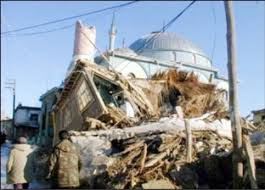
The 2008 Qeshm earthquake occurred on 10 September in the Hormozgān Province of southern Iran, 850 kilometres (528 mi) south of Tehran. Its epicenter was near the port city of Bandar Abbas, where an earthquake two years prior had caused damage. The earthquake measured 5.9 on the moment magnitude scale and 6 on the surface wave scale, killing seven people and injuring up to 45. Causing both catastrophic and minor damage, the earthquake devastated up to 200 villages throughout southern Iran, but left the port city of Bandar Abbas almost unscathed. Citizens reportedly panicked when the earthquake hit, emptying into the parks of the city and other open areas.

The 2013 Bushehr earthquake occurred with a moment magnitude of 6.3 on April 9 in Iran. The shock's epicenter was in the province of Bushehr, near the city of Khvormuj and the towns of Kaki and Shonbeh. At least 37 people were killed, mostly from the town of Shonbeh and villages of Shonbeh-Tasuj district, and an estimated 850 people were injured.
The following lists events that happened during 1972 in Iran.
The 2010 Damghan earthquake occurred in northern Iran at on August 27 with a moment magnitude of 5.8 and maximum Mercalli intensity of VII. This strike-slip event damaged and destroyed a number of small villages in a sparsely populated region near the Alborz mountain range. It left four people dead, 40 injured, and about 800 without homes. The deaths and injuries in this moderate event were attributed to the low-quality construction styles that are typical of the area. The Iranian Strong Motion Network provided data by which seismologists determined the type and extent of the slip as well as the peak ground acceleration. Other large and destructive earthquakes have affected Semnan Province, including several events in 856 AD and 1953.
The 1992 Murindó earthquake occurred on October 18 at 15:11 UTC with an epicenter in the Department of Chocó, northern Colombia. The shallow magnitude 7.2 earthquake struck northwest of the town of Murindó, killing ten and injured more than a hundred. Thirty-three municipalities were severely damaged.

On 12 November 2017 at 18:18 UTC, an earthquake with a moment magnitude of 7.3 occurred on the Iran–Iraq border, with the Iraqi Kurdish city of Halabja, and the Kurdish dominated places of Ezgeleh, Salas-e Babajani County, Kermanshah Province in Iran, closest to the epicentre, 30 kilometres (19 mi) south of the city of Halabja, Iraqi Kurdistan.
The Afyon Province of western Turkey was struck by an earthquake measuring 6.5 on 3 February 2002 at 10:11 local time. It had a maximum felt intensity of VIII (Severe) on the Modified Mercalli intensity scale. It damaged hundreds of buildings and caused the deaths of 44 people and a further 318 injuries.
The first and most destructive of the 2020 Iran–Turkey earthquakes occurred on 23 February, near Khoy in north-west Iran, close to the border with Turkey, killing 9 people in Başkale, Van. It hit at 9:23 a.m. local time with a magnitude of 5.8 at a depth of 6 kilometres and the epicenter was Qotur district, according to the Iranian Seismological Center (IRSC). About 10 hours later the same area was hit by another major earthquake of 6.0 Mw .
The 1906 Manasi earthquake (玛纳斯地震), also known as the Manas earthquake occurred in the morning of December 23, 1906, at 02:21 UTC+8:00 local time or December 22, 18:21 UTC. It measured 8.0–8.3 on the moment magnitude scale and 8.3 on the surface-wave magnitude scale. The epicenter of this earthquake is located in Manas County, Xinjiang, China. An estimated 280–300 people died and another 1,000 more were injured by the earthquake.
The 1979 Ghaenat earthquakes were a series of large earthquakes in Qaen County, Khorasan Province, northeast Iran, near the Afghanistan border. The first mainshock, known as the Korizan earthquake with a surface wave magnitude (Ms ) of 6.6 and moment magnitude (Mw ) of 6.8, struck on November 14, while the Ms 7.1 or Mw 7.2 Koli-Boniabad earthquake struck on November 27. The two mainshocks were assigned a maximum Modified Mercalli intensity of VIII (Severe) and X (Extreme), respectively. The earthquakes caused extensive damage throughout northeastern Iran, killing an estimated 297 to 440 people and left at least 279 injured.

The 2021 Hormozgan earthquakes was a doublet earthquake event in Iran that occurred on November 14, 2021 with magnitudes of 6.0 and 6.4 on the moment magnitude scale. The two quakes occurred just a minute and a half apart, killing 2 people and injuring a further 100.
The 1997 Bojnurd earthquake occurred on 4 February at 14:07 IRST in Iran. The epicenter of the 6.5 earthquake was in the Kopet Dag mountains of North Khorasan, near the Iran–Turkmenistan border, about 579 km (360 mi) northeast of Tehran. The earthquake is characterized by shallow strike-slip faulting in a zone of active faults. Seismic activity is present as the Kopet Dag is actively accommodating tectonics through faulting. The earthquake left 88 dead, 1,948 injured, and affected 173 villages, including four which were destroyed. Damage also occurred in Shirvan and Bojnord counties. The total cost of damage was estimated to be over US$ 30 million.
The 2019 East Azerbaijan earthquake occurred at 03:17 local-time on November 8, 2019. This earthquake had a moment magnitude of 5.9 and had a shallow depth of 20 km.
The 1977 Bob–Tangol earthquake struck Kerman province of Iran on December 20, 1977 at 03:04 Iran Standard Time. The earthquake measured 5.9 and struck at a depth of 22.7 km (14.1 mi). A maximum Modified Mercalli intensity of VII was evaluated based on damage. It had a strike-slip focal mechanism, which was unusual as the source structure was a thrust fault. It was part of a sequence of strong earthquakes along the 400 km (250 mi) Kuh Banan Fault. Between 584 and 665 people perished while a further 500–1,000 were injured; thousands were also made homeless. Casualties from the earthquake was considered moderate due to the sparsely populated area it affected. Preceded by foreshocks the month before, many residents became wary of a larger earthquake and took refuge outside their homes, contributing to the moderate death toll. However, there were none immediately before the mainshock so many were still in their homes when it struck. Aftershocks were felt for several months, some causing additional damage.
The 1977 Naghan earthquake struck Chaharmahal and Bakhtiari province in Iran on April 6 at 13:36 UTC. The earthquake measuring 6.0 Mw occurred at a depth of 15 km (9.3 mi) and had a maximum Modified Mercalli intensity of VIII (Severe). More than 2,100 homes were destroyed and at least 348 people were killed.
The 1977 Khurgu earthquake struck southern Iran near Bandar Abbas in Hormozgan province on the morning of March 22. The earthquake measuring moment magnitude (Mw ) 6.7 struck at a depth of 12.5 km (7.8 mi). Thirty five villages were heavily damaged including over 20 which were destroyed. There were 152–167 people killed and 556 injured.
The 1957 Sangchal earthquake struck northern Iran's Mazandaran province on 2 July 1957. It had a moment magnitude of 6.6 or 7.1 (Mw ), focal depth of 15 km (9.3 mi), and maximum Modified Mercalli intensity of IX (Violent). It devastated many communities in the Alborz Mountains and caused an estimated 1,500 fatalities. Damage was estimated at US$ 25 milion.
The 1957 Farsinaj earthquake struck Hamadan, Iran on 13 December at 05:15 local time. The moment magnitude 6.5 earthquake destroyed 211 villages, killed approximately 1,130 people, and left another 900 injured.

