 | ||||
|---|---|---|---|---|
| Route information | ||||
| Length | 280 km (170 mi) | |||
| Major junctions | ||||
| Northwest end | ||||
| Southeast end | ||||
| Location | ||||
| Country | South Africa | |||
| Highway system | ||||
| ||||
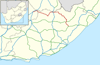
The R385 is a regional route in South Africa that connects Olifantshoek with Hopetown via Postmasburg and Douglas. [1]
| | ||||
|---|---|---|---|---|
| Route information | ||||
| Length | 280 km (170 mi) | |||
| Major junctions | ||||
| Northwest end | ||||
| Southeast end | ||||
| Location | ||||
| Country | South Africa | |||
| Highway system | ||||
| ||||
The R385 is a regional route in South Africa that connects Olifantshoek with Hopetown via Postmasburg and Douglas. [1]
The R385 begins south of Olifantshoek, at a junction with the N14 national route. It begins by going south-east for 54 kilometres to the town of Postmasburg, where it intersects with the R325 road. It continues eastwards for 50 kilometres to meet the R31 road north of Lime Acres. At this junction, the R385 turns southwards and proceeds to enter Lime Acres. [1]
From Lime Acres, the R385 continues southwards for 63 kilometres to meet the N8 national route at Campbell. It proceeds southwards for 28 kilometres to meet the southern terminus of the R370 road and cross the Vaal River to enter the town of Douglas as Bowker Street. [1]
In Douglas Central, the R385 reaches a junction with the R357 road (Roper Street; Loch Street) and becomes co-signed with it eastwards for 3.5 kilometres before the R357 becomes its own road north-east while the R385 turns to the south-east. The R385 continues south-east, following the Orange River, for 69 kilometres to reach its end at a junction with the N12 national route just north of Hopetown. [1]

The R27 is a provincial route in South Africa that consists of two disjoint segments. The first segment, also known as the West Coast Highway, connects Cape Town with Velddrif along the West Coast. The second runs from Vredendal via Vanrhynsdorp, Calvinia, Brandvlei and Kenhardt to Keimoes on the N14 near Upington. The connection between Velddrif and Vredendal has never been built, although it can be driven on various gravel roads.

The R29 is a provincial route in South Africa that connects Johannesburg with Leandra and Kinross via Germiston, Boksburg, Benoni and Springs. For much of its route it is named Main Reef Road. The R29 used to end near the Golela border post with Eswatini, however the section from Evander to Ermelo is now part of the N17 and the section from Ermelo to the Golela border post just after Pongola is now part of the N2.

The R33 is a provincial route in South Africa that connects Pietermaritzburg with Lephalale via Greytown, Paulpietersburg, Carolina, Belfast and Vaalwater. It is a very long road, passing through 3 provinces.

The R34 is a long provincial route in South Africa that connects Vryburg with Richards Bay via Kroonstad and Newcastle. It passes through three provinces, North West, the Free State and KwaZulu-Natal.

The R36 is a provincial route in South Africa that connects the N1 at Bandelierkop with Ermelo, via Tzaneen and Lydenburg. It is co-signed with the N4 for 8 kilometres between Machadodorp and Patattanek, with a tollgate on this section. It used to extend further south past Ermelo to Amersfoort, but that section is now designated as part of the N11.

The R37 is a provincial route in South Africa that connects Polokwane with Mbombela via Burgersfort and Lydenburg (Mashishing).

The R44 is a provincial route in Western Cape, South Africa that connects Piketberg with Kleinmond via Wellington, Stellenbosch, Somerset West and Strand. The coastal section between Kleinmond and Gordon's Bay is a very scenic ocean drive. The section between Gordon's Bay and Stellenbosch via Strand and Somerset West is a dual carriageway. The R44 is co-signed with the R46 between Gouda and Hermon in the Berg River valley.

The R56 is a provincial route in South Africa that connects Middelburg with Pietermaritzburg via Molteno, Maclear and Kokstad. It is co-signed with the N2 between Kokstad and Stafford's Post for 39 kilometres.

The R57 is a provincial route in South Africa that connects Vanderbijlpark with Phuthaditjhaba via Sasolburg, Heilbron and Reitz.
The R58 is a provincial route in South Africa that connects Colesberg with Ngcobo via Aliwal North, Barkly East and Khowa.

The R63 is a tarred provincial route in South Africa that connects Calvinia with Komga via Carnarvon, Victoria West, Graaff-Reinet, Somerset East and King William's Town. It is cosigned with the N10 between Eastpoort and Cookhouse for 24 kilometres.

The R71 is a provincial route in Limpopo, South Africa that connects Polokwane with the Kruger National Park via Tzaneen and Phalaborwa.
The R369 is a Regional Route in South Africa that connects the R357 near Prieska with Colesberg via Hopetown.

The N12 is a national route in South Africa which runs from George through Beaufort West, Kimberley, Klerksdorp and Johannesburg to eMalahleni.

The N8 is a national route in South Africa that connects Groblershoop with Maseru in Lesotho via Kimberley and Bloemfontein. It is maintained by the South African National Roads Agency.

The N10 is a national route in South Africa connecting Gqeberha on the Eastern Cape coast with the Namibian border at Nakop, via Cradock, De Aar and Upington.

The N11 is a national route in South Africa which runs from the Botswana border at Groblersbrug, through Mokopane, Middelburg, Ermelo and Newcastle to end at the N3 just after Ladysmith.

The N14 is a national route in South Africa which runs from Springbok in the Northern Cape to Pretoria in Gauteng. It passes through Upington, Kuruman, Vryburg, Krugersdorp and Centurion. The section between Pretoria and Krugersdorp is maintained by the Gauteng Provincial government and is also designated the P158.
The R500 is a Regional Route in South Africa that connects Magaliesburg with Parys via Carletonville and Fochville.

The M4 is a long metropolitan route in the City of Cape Town Metropolitan Municipality in South Africa. It connects the Cape Town CBD with the Cape of Good Hope via Wynberg, Muizenberg and Fish Hoek. Originally, it was the main route connecting the Cape Town CBD with the Southern Suburbs and is thus named Main Road for much of its length. From the CBD to Kirstenhof, it is parallel to the M3 Freeway.
| | This South African road or road transport-related article is a stub. You can help Wikipedia by expanding it. |