 | ||||
|---|---|---|---|---|
| Route information | ||||
| Length | 106 km (66 mi) | |||
| Major junctions | ||||
| West end | ||||
| East end | ||||
| Location | ||||
| Country | South Africa | |||
| Highway system | ||||
| ||||
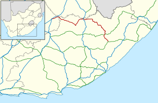
The R410 is a Regional Route in South Africa that connects Komani with Khowa via Lady Frere and Cala. [1]
| | ||||
|---|---|---|---|---|
| Route information | ||||
| Length | 106 km (66 mi) | |||
| Major junctions | ||||
| West end | ||||
| East end | ||||
| Location | ||||
| Country | South Africa | |||
| Highway system | ||||
| ||||
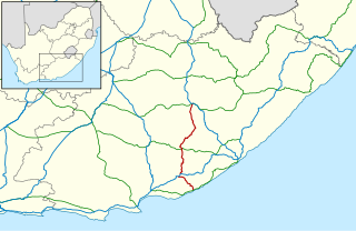
The R410 is a Regional Route in South Africa that connects Komani with Khowa via Lady Frere and Cala. [1]
Its western terminus is a junction with the R392 approximately 9 kilometres east of Komani, next to the Bongolo Dam. It heads east-north-east for 38 kilometres, crossing the White Kei River, to reach the town of Lady Frere. It proceeds east-north-east for 52 kilometres, meeting the southern terminus of the R396, to cross the Tsomo River and enter the town of Cala, where it passes through as Titsa Street. It continues north-east as the Cala Pass for 14 kilometres to end at a junction with the R58 approximately 14 kilometres south-west of Khowa. [1]

The R30 is a provincial route in South Africa that connects Bloemfontein with Rustenburg via Brandfort, Welkom, Bothaville, Klerksdorp and Ventersdorp. The southern part of the route is tolled, as the R30 forms the first section of the ZR Mahabane Toll Route, with the Brandfort Toll Plaza found 10 kilometres north of its southern terminus junction with the N1 national route. The tolled portion ends at the junction with the R730.

The R34 is a long provincial route in South Africa that connects Vryburg with Richards Bay via Kroonstad and Newcastle. It passes through three provinces, North West, the Free State and KwaZulu-Natal.

The R36 is a provincial route in South Africa that connects the N1 at Bandelierkop with Ermelo, via Tzaneen and Lydenburg. It is co-signed with the N4 for 8 kilometres between Machadodorp and Patattanek, with a tollgate on this section. It used to extend further south past Ermelo to Amersfoort, but that section is now designated as part of the N11.

The R37 is a provincial route in South Africa that connects Polokwane with Mbombela via Burgersfort and Lydenburg (Mashishing).

The R45 is a provincial route in Western Cape, South Africa that connects Saldanha with Villiersdorp via Vredenburg, Malmesbury and Paarl. The route is mostly a two-lane wide-shouldered highway, however sections within Paarl and between Vredenburg and Saldanha are dual-carriageways. The R45 is co-signed with the N7 for a short segment north of Malmesbury.

The R56 is a provincial route in South Africa that connects Middelburg with Pietermaritzburg via Molteno, Maclear and Kokstad. It is co-signed with the N2 between Kokstad and Stafford's Post for 39 kilometres.
The R58 is a provincial route in South Africa that connects Colesberg with Ngcobo via Aliwal North, Barkly East and Khowa.

The R59 is a provincial route in South Africa that connects Hertzogville with Alberton via Bothaville, Parys and Vereeniging. The R59 is a freeway from the R57 Junction in Sasolburg until the N12 Reading Interchange in Alberton, signposted as the Sybrand van Niekerk Freeway.

The R61 is a long provincial route in South Africa that connects Beaufort West with Port Shepstone via Graaff-Reinet, Komani, Mthatha and Port Edward.

The R63 is a tarred provincial route in South Africa that connects Calvinia with Komga via Carnarvon, Victoria West, Graaff-Reinet, Somerset East and King William's Town. It is cosigned with the N10 between Eastpoort and Cookhouse for 24 kilometres.
The R67 is a provincial route in Eastern Cape, South Africa that connects Port Alfred with Komani via Grahamstown.

The R71 is a provincial route in Limpopo, South Africa that connects Polokwane with the Kruger National Park via Tzaneen and Phalaborwa.

The R72 is a provincial route in Eastern Cape, South Africa that connects the N2 north-east of Gqeberha with East London via Port Alfred. It provides an alternative to the N2 for travel between Gqeberha and East London.

The R74 is a provincial route in South Africa that connects Harrismith with KwaDukuza on the coast, via Oliviershoek Pass, Bergville, Winterton, Colenso, Weenen and Greytown.

The R76 is a provincial route in Free State, South Africa that connects Orkney with Bethlehem via Kroonstad.
The R103 is a Regional Route in South Africa that is the designation for some of the old sections of roads that were previously the N3, prior to upgrading. It only has 3 sections, from Hillcrest to Ladysmith, from Warden to Villiers and from Heidelberg to Johannesburg.
The R392 is a Regional Route in South Africa that connects Walaza with Komani via Sterkspruit, Lady Grey and Dordrecht.

The N6 is a national route in South Africa that connects East London with Bloemfontein, via Komani and Maletswai. It runs roughly from north to south, connecting the N1 with the N2.

The N11 is a national route in South Africa which runs from the Botswana border at Groblersbrug, through Mokopane, Middelburg, Ermelo and Newcastle to end at the N3 just after Ladysmith.
| | This South African road or road transport-related article is a stub. You can help Wikipedia by expanding it. |