
The Great Kei River is a river in the Eastern Cape province of South Africa. It is formed by the confluence of the Black Kei River and White Kei River, northeast of Cathcart. It flows for 320 km (199 mi) and ends in the Great Kei Estuary at the Indian Ocean with the small town Kei Mouth on the west bank. Historically the Great Kei River formed the southwestern border of the Transkei region as was formerly known as the Nciba River.

The Nahoon River is situated in the city of East London on the east coast of South Africa.

Chris Hani is a landlocked district situated in the centre of the Eastern Cape and is made up of eight local municipalities. Most of the communities live in rural areas. The landscape ranges from moist uplands and grassland hills to the arid Karoo scrubland.

The Diocese of Grahamstown is a diocese of the Anglican Church of Southern Africa. It is centred on the historic city of Makhanda in the Eastern Cape Province of South Africa. The diocese extends to East London, in the east and Port Alfred to the south.

Cacadu is a small town in Chris Hani District Municipality in the Eastern Cape province of South Africa. The town was renamed to Cacadu in 2017, after amendments of changing colonial names in South Africa. Cacadu, meaning “bulrush water”, is the Xhosa name for the White Kei River, which rises in the district.
East London Coast Nature Reserve is a protected area in Eastern Cape Province, South Africa that is managed by Eastern Cape Parks.
Kei Mouth is a resort town on the southeast coast of South Africa, situated in the Wild Coast region of the Eastern Cape Province, situated 94 kilometres from the city of East London. The town is situated on the Indian Ocean coast, on the western bank of the Great Kei River, and has one of the country's three remaining car transporting pontoon river ferries.
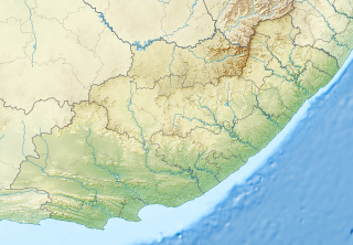
Mzimvubu to Keiskamma WMA, or Mzimvubu to Keiskamma Water Management Area , includes the following major rivers: the Swane River, Mntafufu River, Mzimvubu River, Mngazi River, Mthatha River, Xora River, Mbashe River, Nqabara River, Gqunube River, Buffalo River, Nahoon River, Groot Kei River and Keiskamma River, and covers the following Dams:
Xonxa Dam, is a composite zoned earthfill/rockfill dam situated on the White Kei River in Eastern Cape, South Africa. It was established in 1972 and has a capacity of 158,500,000 cubic metres (5.60×10⁹ cu ft). The wall is 48 metres (157 ft) high. The dam serves mainly for irrigation purposes and its hazard potential has been ranked high (3).

The Komani River, is a river part of the Great Kei River system in the Eastern Cape, South Africa. It is a short river originating north of Queenstown and joining up with the Klaas Smits River, just south of the same town.
The Klaas Smits River is a river part of the Great Kei River system in the Eastern Cape, South Africa. It originates south of Molteno and flows through Sterkstroom, first southwards and then southeastwards before joining up with the Black Kei River. Presently the Klaas Smits River is part of the Mzimvubu to Keiskama Water Management Area.
The Black Kei River, originates southwest of Queenstown, and eventually joins the White Kei River, to become the Great Kei River. Several villages are situated on its banks, including McBride Village, Qabi, Ntabelanga, Thornhill, Loudon, Mitford, Basoto, Baccle's Farm and Tentergate.

The Ngqika people are a Xhosa monarchy who lived west of the Great Kei River in what is today the Eastern Cape of South Africa. They were first ruled by Rarabe kaPhalo who died with his son Mlawu, who was destined for chieftaincy. The clan would be named after Ngqika ka Mlawu, the son of the then late Mlawu. It would be years before the child would rule his people who fought in the Xhosa Wars, which were sparked by the encroachment of European settlers on Xhosa lands.
Great Kei Local Municipality is an administrative area in the Amathole District of the Eastern Cape in South Africa. The name "Kei" is of Khoi origin, meaning "sand". The municipality is named after the Great Kei River.

The Keiskamma River is a river in the Eastern Cape Province in South Africa. The river flows into the Indian Ocean in the Keiskamma Estuary, located by Hamburg Nature Reserve, near Hamburg, midway between East London and Port Alfred. The Keiskamma flows first in a southwestern and then in a southeastern direction after meeting its main tributary, the Tyhume River.
The Klipplaat River is a river in the Eastern Cape Province of South Africa.
The Tsomo River is a river in the Eastern Cape Province of South Africa. It is a tributary of the Great Kei River.
The Amathole Offshore Marine Protected Area is an offshore conservation region in the territorial waters of South Africa
The Amathole Marine Protected Area is an inshore conservation region in the territorial waters of South Africa, near East London on the coast of the Eastern Cape.
