
Modes of transport in Mozambique include rail, road, water, and air. There are rail links serving principal cities and connecting the country with Malawi, Zimbabwe and South Africa. There are over 30,000 km of roads, but much of the network is unpaved.

Mbombela, formerly Nelspruit, is a city in northeastern South Africa. It is the capital of the Mpumalanga province. Located on the Crocodile River, the city lies about 110 km (68 mi) by road west of the Mozambique border, 330 km (210 mi) east of Johannesburg and 82 km (51 mi) north of the Eswatini border. Mbombela was one of the host cities of the 2010 FIFA World Cup.

National routes in South Africa are a class of trunk roads and freeways which connect major cities. They form the highest category in the South African route numbering scheme, and are designated with route numbers beginning with "N", from N1 to N18. Most segments of the national route network are officially proclaimed National Roads that are maintained by the South African National Roads Agency (SANRAL), but some segments are maintained by provincial or local road authorities.
The Netherlands–South African Railway Company or NZASM was a railway company established in 1887. The company was based in Amsterdam and Pretoria, and operated in the South African Republic (ZAR) during the late 19th century. At the request of ZAR president Paul Kruger, the NZASM constructed a railway line between Pretoria and Lourenço Marques in Portuguese East Africa.
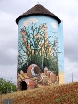
Kaapmuiden(Cape Mouth) is a small farming town situated at the confluence of the Kaap and Crocodile Rivers in Mpumalanga, South Africa. The town lies just off the N4 national highway and is marked by a large abandoned silo visible from the road. The silo has since been repainted to add to tourism appeal. The farms in the region produce sugarcane, subtropical fruit and vegetables. The town began as a junction on the Netherlands-South African Railway Company (NZASM)'s Pretoria - Delagoa Bay railway line.

Komatipoort is a town situated at the confluence of the Crocodile and Komati Rivers in Mpumalanga province, South Africa. The town is 8 km from the Crocodile Bridge Gate into the Kruger National Park, just 5 km from the Mozambique border and 65 km from the Eswatini border.
Malalane, alternatively rendered Malelane, is a farming town in Mpumalanga, South Africa situated on the N4 national highway. The farms in the region produce sugarcane, subtropical fruit and winter vegetables. The town was proclaimed in 1949 after which it was named. The origin of the name is disputed but was corrupted from the Swazi. Either the expression "eMlalani" which means place of the palms, or the expression "lala" which means to sleep is accepted origins of the name. The town started as the first rest-stop between Lourenço Marques and Pretoria. As of July 2007 the town was officially renamed from "Malelane" to "Malalane" as part of the government's renaming scheme by the South African Geographical Names Council.

The R33 is a provincial route in South Africa that connects Pietermaritzburg with Lephalale via Greytown, Paulpietersburg, Carolina, Belfast and Vaalwater. It is a very long road, passing through 3 provinces.

The R35 is a provincial route in Mpumalanga, South Africa that connects Amersfoort with Middelburg via Morgenzon and Bethal. The R35 used to connect with the N3 near Ladysmith, but the portion of the road from Amersfoort onwards is now part of the N11.

The R40 is a provincial route in South Africa that connects the Eswatini border at Bulembu via Barberton, Mbombela, Bushbuckridge, Acornhoek and Hoedspruit with Phalaborwa. The route spans two provinces and passes through several private game reserves.

The Komati River, also known as the Inkomati River or Incomati River, is a river in South Africa, Eswatini and Mozambique. Originating in north-western Eswatini, it is joined by the Crocodile River in the Lebombo Mountains, enters far south-western Mozambique below the border town of Komatipoort, and enters the Indian Ocean around 24 km (15 mi) north-east of Maputo.

The N4 is a national route in South Africa that runs from Skilpadshek on the Botswana border, past Rustenburg, Pretoria, eMalahleni and Mbombela, to Komatipoort on the Mozambique border. The entire route is a toll road.
The Trans-Kalahari Corridor is a paved highway corridor that provides a direct route from the port of Walvis Bay and Windhoek in central Namibia, through Botswana, to Pretoria in Gauteng province in South Africa. It initially cost approximately 850 million Namibian dollars and was officially opened in 1998.
Eswatini Railways (ESR), formerly known as Swaziland Railway or Swazi Rail, is the national railway corporation of Eswatini.

The N11 is a national route in South Africa which runs from the Botswana border at Groblersbrug, through Mokopane, Middelburg, Ermelo and Newcastle to end at the N3 just after Ladysmith.
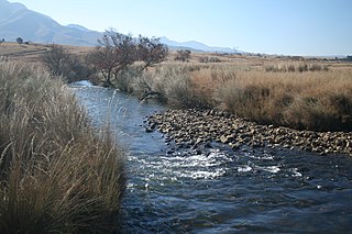
The Crocodile River, also referred to as Crocodile River (East), (Afrikaans: Krokodilrivier) is a large river traversing Mpumalanga province of South Africa. It is a tributary of the Komati River.

Marloth Park is a holiday town situated in northeastern South Africa in the Mpumalanga province.
The R538 is a Regional Route in Mpumalanga, South Africa. The route begins east of Mbombela and passes through White River to connect with Hazyview.
The R570 is a Regional Route in Mpumalanga, South Africa.

Crocodile Bridge is the name of both a camp along the southern border of Kruger National Park and a gate to the park in Mpumalanga Province of South Africa. The gate is at a low water bridge crossing the Crocodile River and leads directly to the Crocodile Bridge rest camp. The park entry, including payment, is adjacent to the camp itself.
