The R713 is a Regional Route in Free State, South Africa. [1]
 | ||||
|---|---|---|---|---|
| Location | ||||
| Country | South Africa | |||
| Highway system | ||||
| ||||
The R713 is a Regional Route in Free State, South Africa. [1]
| | ||||
|---|---|---|---|---|
| Location | ||||
| Country | South Africa | |||
| Highway system | ||||
| ||||
Its north-western terminus is the R30, 25 km south of Bothaville and 35 km north of Odendaalsrus. It runs east-south-east to end at a junction with the R34, 15 km south-west of Kroonstad and 30 km north-east of Odendaalsrus. [1]

Mbombela, formerly Nelspruit, is a city in northeastern South Africa. It is the capital of the Mpumalanga province. Located on the Crocodile River, the city lies about 110 km (68 mi) by road west of the Mozambique border, 330 km (210 mi) east of Johannesburg and 82 km (51 mi) north of the Eswatini border. Mbombela was one of the host cities of the 2010 FIFA World Cup.

The N1 is a national route in South Africa that runs from Cape Town through Bloemfontein, Johannesburg, Pretoria and Polokwane to Beit Bridge on the border with Zimbabwe. It forms the first section of the famed Cape to Cairo Road.

Kroonstad, which consist of suburbs as follows: Brentpark, Constantia, Constantia Park, Dawid Malanville, Elandia, Gelukwaarts, Goedgedacht, Heuningspruit, Industria, Jordania, KoeKoeVillage, Kroonheuwel, Maokeng, Morewag, Noordhoek, Ou Dorp, Panorama, Phomalong, Presidensia, PrisonArea, Seisoville, Suidrand, Tuinhof, Uitsig, Vooruitsig, WestPark and Wilgenhof. Kroonstad is the fourth largest town in the Free State and lies two hours' drive on the N1 from Gauteng. It is the second-largest commercial and urban centre in the Northern Free State, and an important railway junction on the main line from Cape Town to Johannesburg.

Welkom is the second-largest city in the Free State province of South Africa, located about 140 kilometres (90 mi) northeast of Bloemfontein, the provincial capital. Welkom is also known as Circle City, City Within A Garden, Mvela and Matjhabeng. The city's Sesotho name, Matjhabeng means 'where nations meet', derived from the migrant labour system, where people of various countries such as Lesotho, Malawi and Mozambique etc. met to work in the mines of the gold fields.

Odendaalsrus is the oldest gold mining town in the Lejweleputswa District Municipality in the goldfields of the Free State province in South Africa.

Ventersburg is a small town in the Lejweleputswa District Municipality of the Free State province in South Africa, 148 km north of Bloemfontein.

The R25 is a provincial route in South Africa that connects Johannesburg with Groblersdal via Kempton Park, Bapsfontein and Bronkhorstspruit.

The R29 is a provincial route in South Africa that connects Johannesburg with Leandra and Kinross via Germiston, Boksburg, Benoni and Springs. For much of its route it is named Main Reef Road. The R29 used to end near the Golela border post with Eswatini, however the section from Evander to Ermelo is now part of the N17 and the section from Ermelo to the Golela border post just after Pongola is now part of the N2.

The R30 is a provincial route in South Africa that connects Bloemfontein with Rustenburg via Brandfort, Welkom, Bothaville, Klerksdorp and Ventersdorp. The southern part of the route is tolled, as the R30 forms the first section of the ZR Mahabane Toll Route, with the Brandfort Toll Plaza found 10 kilometres north of its southern terminus junction with the N1 national route. The tolled portion ends at the junction with the R730.

The R34 is a long provincial route in South Africa that connects Vryburg with Richards Bay via Kroonstad and Newcastle. It passes through three provinces, North West, the Free State and KwaZulu-Natal.

The R70 is a provincial route in the Free State Province, South Africa that connects Odendaalsrus with Ficksburg via Ventersburg and Senekal.

The N2 is a national route in South Africa that runs from Cape Town through George, Gqeberha, East London, Mthatha, Port Shepstone and Durban to Ermelo. It is the main highway along the Indian Ocean coast of the country. Its current length of 2,255 kilometres (1,401 mi) makes it the longest numbered route in South Africa.

The N12 is a national route in South Africa which runs from George through Beaufort West, Kimberley, Klerksdorp and Johannesburg to eMalahleni.
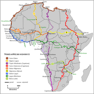
The Trans-African Highway network comprises transcontinental road projects in Africa being developed by the United Nations Economic Commission for Africa (UNECA), the African Development Bank (ADB), and the African Union in conjunction with regional international communities. They aim to promote trade and alleviate poverty in Africa through highway infrastructure development and the management of road-based trade corridors. The total length of the nine highways in the network is 56,683 km (35,221 mi).

The N10 is a national route in South Africa connecting Gqeberha on the Eastern Cape coast with the Namibian border at Nakop, via Cradock, De Aar and Upington.

Phakisa Freeway is a motor racing circuit located between Welkom and Odendaalsrus, South Africa. It is one of the few oval speedways outside of the United States and the only one in Africa.

Matjhabeng Municipality is a local municipality within the Lejweleputswa District Municipality, in the Free State province of South Africa. The municipality includes Welkom, Virginia, Odendaalsrus and Allanridge. Matjhabeng is a Sesotho word meaning "where nations meet". It is derived from the migrant labour system where people from various countries like Lesotho, Mozambique, etc. met to work in the mines.

The South African Railways Class 3B 4-8-2 of 1912 was a steam locomotive.
The R719 is a Regional Route in South Africa.
The R730 is a Regional Route in Free State, South Africa. The entire 40-kilometre route is part of the ZR Mahabane Toll Route maintained by the South African National Roads Agency, which goes from Bloemfontein to Kroonstad. Although there are no tollgates on this stretch at the moment, it is labelled as a toll road to the near public and to motorists using the road.
| | This South African road or road transport-related article is a stub. You can help Wikipedia by expanding it. |