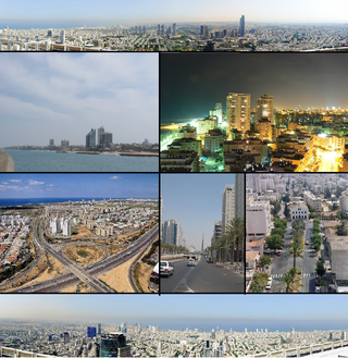
Gush Dan or Tel Aviv metropolitan area is a conurbation in Israel, located along the country's Mediterranean coastline. There is no single formal definition of Gush Dan, though the term is in frequent use by both governmental bodies and the general public. It ranges from combining Tel Aviv with cities that form an urban continuum with it, to the entire areas from both the Tel Aviv District and the Central District, or sometimes the whole Metropolitan Area of Tel Aviv, which includes a small part of the Southern District as well. Gush Dan is the largest conurbation and metropolitan area in Israel, with the metropolitan area having an estimated population of 4,156,900 residents, 89% of whom are Israeli Jews.

The Tel Aviv Light Rail, Arabic: دانكال تل أبيب للسكك الحديدية الخفيفة, Romanized: Dankal Tal 'Abib Lilsikak Al-hadidiat Al-khāfifa also known as Dankal is a mass transit system for Gush Dan, the Tel Aviv metropolitan area in central Israel. The system will include different modes of mass transit, including rapid transit (metro), light rail transit (LRT), and bus rapid transit (BRT). Overseen by NTA Metropolitan Mass Transit System Ltd., a government agency, the project will complement the intercity and suburban rail network operated by Israel Railways.

Metropoline is an Israeli bus company, which provides bus routes from Beersheba to Tel Aviv and other destinations in the Southern District, Intracity and intercity routes in the Southern Sharon region, Ono Valley region and El'ad. It was founded in 2000 by Tour Bus and two other transportation companies.

Highway 20, more commonly known as the Ayalon Highway, or simply Ayalon, is a major inter city freeway in Gush Dan, Israel. The road runs along the eastern border of central Tel Aviv from north to south and connects all of the major highways leading to the city—such as Highway 4 from Ashdod and the Southern regions, Highway 2 from Haifa and the Northern regions, Highway 5 from the East, and Highway 1 from Jerusalem and the Southeast. The Ayalon Highway is heavily used; on an average day, almost 600,000 vehicles enter the freeway. It consists of a multi-lane highway with a multi-track railway located between the opposite travel lanes. Some of the highway's route is along the Ayalon River, hence its name.

Tel Aviv University railway station is an Israel Railways station in northern Tel Aviv, Israel. It is officially named Tel Aviv Universita – Merkaz HaYeridim in Hebrew, due to its proximity to Tel Aviv University and Expo Tel Aviv.

Hod Hasharon Sokolov railway station is a passenger railway station located at the town boundary of Hod HaSharon and Kfar Saba, Israel. Until July 2018 it was the northern terminus of the suburban line to Beersheba via Tel Aviv. The station was opened on 2 September 2006 as Kfar Saba Merkaz; at the same time, the neighbouring Kfar Saba–Nordau railway station was renamed Hod HaSharon station. On 6 March 2010, both stations were renamed to their present names.

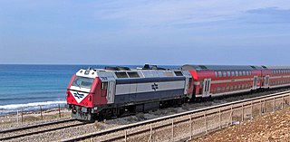
Rail transport in Israel includes heavy rail as well as light rail. Excluding light rail, the network consists of 1,511 kilometers (939 mi) of track, and is undergoing constant expansion. All of the lines are standard gauge and as of 2023 approximately one-fifth of the heavy rail network is electrified, with additional electrification work underway. A government owned rail company, Israel Railways, manages the entire heavy rail network. Most of the network is located on the densely populated coastal plain.

Rehovot railway station is an Israel Railways station located in the city of Rehovot. It serves the city, the Weizmann Institute of Science and the nearby science industries park, as well as the city of Ness Ziona. The station is named after Ehud Hadar, CEO of Israel Railways between 1994 and 1996.

The Tel Aviv transportation system is seen as the hub of the Israeli transport network in terms of road, rail, and air transport. The Israeli road network partly centers on Tel Aviv, with some of the country's largest highways passing through or running to the city. The city forms a major part of the country's rail network, whilst Ben Gurion International Airport located near the city is the country's largest airport. There is also a strong public transport system within the city, based primarily on bus transportation.

Bnei Brak–Ramat HaHayal railway station is a suburban passenger railway station in Israel, operated by Israel Railways. It is located on the Yarkon Railway near the Bnei Brak–Ramat Gan and Bnei Brak–Tel Aviv borders next to the Ayalon Mall and Ramat Gan Stadium. In spite of its proximity to important industrial and commercial areas of Gush Dan as well as to residential areas of Tel Aviv, Bnei Brak is one of the less-popular stations of Israel Railways, possibly because of its misleading name and lack of awareness. As a result, in an effort to increase the public's awareness of the station, the name of the Ramat HaHayal neighborhood located to the north of the station was added to the station's name in 2016.

Herzliya railway station is an Israel Railways passenger station located in the city of Herzliya. The station currently has three island platforms serving two tracks each. In the 2010s, the Ayalon Highway was extended past the station northwards so that the platforms lie contained in the median of the highway, like the train stations in Tel Aviv.

Route 531, is a suburban freeway in the southern Sharon region of Israel, just north of the Tel Aviv Metropolitan Area. The highway begins at Highway 6 and terminates at the Ayalon Highway with an extension to the Coastal Highway.

Kfar Saba–Nordau railway station is a passenger railway station located at the city boundary of Hod HaSharon, Israel and Kfar Saba, Israel. The station was opened on 13 April 2003 as the beginning of the new Sharon Railway. Eleven days later, on 24 April 2003, a suicide bomber approached the new train station and activated the bomb he was carrying, murdering Alexander Kostyuk, the security guard who had prompted him for identification, and wounding 13 others. The station was later named after Kostyuk who prevented the bomber from entering the station.
The Coastal railway line is a mainline railway in Israel, which begins just south of the Lebanon-Israel border on the Mediterranean coast, near the town of Nahariya in Northern Israel and stretches almost the entire Mediterranean coast of the country, to just north of the border with the Gaza Strip in the south.
Transport in Bnei Brak occupies a central location within the Gush Dan. It has an important role in transport throughout the region.
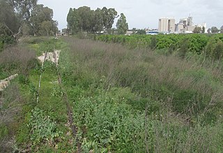
The Eastern Railway refers to a railroad in central Israel stretching from Lod to Hadera. The section between Kfar Saba and Lod, as well as a short section just north of Hadera are currently in use but the rest of the railway has not been operative since 1969. However, in 2019 a large-scale project began to rebuild and upgrade the railway along the entire route.

Ra'anana West railway station is an Israel Railways passenger station in the median of Highway 531, between the cities of Ra'anana and Herzliya, as part of the Sharon Railway.
Sharon Railway is a 12 km double-track railroad in the Sharon plain area of Israel, located in the median of Highway 531. It serves as a connection between the Coastal Railway and the Eastern Railway and runs parallel to the Yarkon Railway which is located approximately 7km to the south. In the vicinity of Ra'anana South interchange, the Sharon Railway passes through a 1.8km long tunnel.
The Yarkon Railway is a double-track railroad following the course of the Yarkon River in the central area of Israel. It is about 15 km long, stretching from the Coastal Railway to the Eastern Railway.
This is a list of the main association football rivalries in Israel.
