
Bougainville, officially the Autonomous Region of Bougainville, is an autonomous region in Papua New Guinea. The largest island is Bougainville Island, while the region also includes Buka Island and a number of outlying islands and atolls. The interim capital is Buka, though it is expected that major government services and buildings will be moved to Arawa, following reconstruction.

Western New Guinea, also known as Papua, is the Indonesian part of the island of New Guinea. Since the island is alternatively named as Papua, the region is also called West Papua. Lying to the west of the independent state of Papua New Guinea, it is the one of the few Indonesian territories to be situated in Oceania. Considered to be a part of the Australian continent, the territory is mostly in the Southern Hemisphere and also includes nearby islands, including the Schouten and Raja Ampat archipelagoes. The region is predominantly covered with ancient rainforest where numerous traditional tribes live, such as the Dani of the Baliem Valley, although a large proportion of the population live in or near coastal areas, with the largest city being Jayapura.

Milne Bay is a province of Papua New Guinea. Its capital is Alotau. The province covers 14,345 km² of land and 252,990 km² of sea, within the province there are more than 600 islands, about 160 of which are inhabited. The province has about 276,000 inhabitants, speaking about 48 languages, most of which belong to the Eastern Malayo-Polynesian branch of the Austronesian language family. Economically the province is dependent upon tourism, oil palm, and gold mining on Misima Island; in addition to these larger industries there are many small-scale village projects in cocoa and copra cultivation. The World War II Battle of Milne Bay took place in the province.
Dame Josephine Abaijah, is a Papua New Guinean former politician. She was the first woman to be elected to the House of Assembly in 1972.

Samarai is an island and former administrative capital in Milne Bay Province, Papua New Guinea.

The Anglican Church of Papua New Guinea is a province of the Anglican Communion. It was created in 1976 when the Province of Papua New Guinea became independent from the Province of Queensland in the Church of England in Australia following Papua New Guinea's independence in 1975.

The New Guinea campaign of the Pacific War lasted from January 1942 until the end of the war in August 1945. During the initial phase in early 1942, the Empire of Japan invaded the Australian-administered Mandated Territory of New Guinea and the Australian Territory of Papua and overran western New Guinea, which was a part of the Netherlands East Indies. During the second phase, lasting from late 1942 until the Japanese surrender, the Allies—consisting primarily of Australian forces—cleared the Japanese first from Papua, then the Mandate and finally from the Dutch colony.
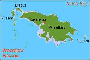
Woodlark Island, known to its inhabitants simply as Woodlark or Muyua, is the main island of the Woodlark Islands archipelago, located in Milne Bay Province and the Solomon Sea, Papua New Guinea.

Papua New Guinea, a sovereign state in Oceania, is the most linguistically diverse country in the world. According to Ethnologue, there are 839 living languages spoken in the country. In 2006, Papua New Guinea Prime Minister Sir Michael Somare stated that "Papua New Guinea has 832 living languages ," Languages with statutory recognition are Tok Pisin, English, Hiri Motu, and Papua New Guinean Sign Language. Tok Pisin, an English-based creole, is the most widely spoken, serving as the country's lingua franca. Papua New Guinean Sign Language became the fourth officially recognised language in May 2015, and is used by the deaf population throughout the country.

Cyclone Guba was the most recent tropical cyclone to form in the Port Moresby area of responsibility. The storm resulted in 149 fatalities and severe damage across southeastern Papua New Guinea in November 2007. The firstly-named cyclone of the 2007–08 Australian region cyclone season, Guba formed on 13 November 2007 close to the island of New Guinea, and reached tropical cyclone intensity the next day by the Tropical Cyclone Warning Centre (TCWC) in Brisbane, with the TCWC in Port Moresby assigning the name Guba. It meandered in the northern Coral Sea for the next week, strengthening to a Category 3 severe tropical cyclone on 16 November. It posed a threat to the Australian Cape York Peninsula, but remained offshore, and finally dissipated on 20 November.

New Guinea Force was a military command unit for Australian, United States and native troops from the Territories of Papua and New Guinea serving in the New Guinea campaign during World War II. Formed in April 1942, when the Australian First Army was formed from the Australian I Corps after it returned from the Middle East, it was responsible for planning and directing all operations within the territory up until October 1944. General Headquarters Southwest Pacific Area Operational Instruction No.7 of 25 May 1942, issued by Commander-Allied-Forces, General Douglas MacArthur, placed all Australian and US Army, Air Force and Navy Forces in the Port Moresby Area under the control of New Guinea Force. Over the course of its existence, New Guinea Force was commanded by some of the Australian Army's most notable commanders, including Sydney Rowell, Sir Edmund Herring and Sir Leslie Morshead.

The continent of Australia, sometimes known in technical contexts by the names Sahul, Australinea, or Meganesia to distinguish it from the country of Australia, consists of the landmasses which sit on Australia's continental plate. The name "Sahul" takes its name from the Sahul Shelf, which is part of the continental shelf of the Australian continent. The continent includes mainland Australia, Tasmania, and the island of New Guinea, which consists of Papua New Guinea and Western New Guinea. Situated in the geographical region of Oceania, Australia is the smallest of the seven traditional continents.

New Guinea is the world's second-largest island and, with an area of 785,753 km2 (303,381 sq mi), the largest island in the Southern Hemisphere. Located in Melanesia in the southwestern Pacific Ocean, it is separated by the 150-kilometre wide Torres Strait from the Australian continent. Numerous smaller islands are located to the west and east. The eastern half of the island is the major land mass of the independent state of Papua New Guinea. The western half, known as Western New Guinea or West Papua, forms a part of Indonesia and is organized as the provinces of Papua and West Papua.
Suki is a Gogodala-Suki language spoken by about 3500 people several miles inland along the Fly River in southwestern Papua New Guinea.
Kaki Ae, or Tate, is a language with about 500 speakers, half the ethnic population, near Kerema, in Papua New Guinea. It was previously known by the foreign designation Raeta Tati.

Abun, also known as Yimbun, Anden, Manif, or Karon, is a Papuan language spoken along the northern coast of the Bird's Head Peninsula in Abun District, Tambrauw Regency. It is not closely related to any other language, and though Ross (2005) assigned it to the West Papuan family, based on similarities in pronouns, Palmer (2018), Ethnologue, and Glottolog list it as a language isolate.
Daga is a non-Austronesian language of Papua New Guinea. Daga is spoken by about 9,000 people as of 2007. The peoples that speak Daga are located in the Rabaraba subdistrict of Milne Bay district, and in the Abau subdistrict of the Central district of Papua New Guinea.

Duriankari, or Duriankere, is a possibly extinct Papuan language of Indonesian Papua. It is associated with the village of Duriankari at the southern tip of the island of Salawati, which is part of the Raja Ampat Archipelago and is adjacent to the Bird's Head Peninsula of the West Papuan mainland.

Kerevat is a town and seat of Gazelle District in East New Britain Province, on the island of New Britain, Papua New Guinea. It is home to a prison, the Kerevat National High School, the Kerevat Education Centre, and the Cocoa and Coconut Research Institute. Its principal crop is cocoa. An airfield was constructed here by the Imperial Japanese in World War II during September 1943.
The Baháʼí Faith in Papua New Guinea begins after 1916 with a mention by ʻAbdu'l-Bahá, then head of the religion, that Baháʼís should take the religion there. The first Baháʼís move there in Papua New Guinea arrived there in 1954. With local converts the first Baháʼí Local Spiritual Assembly was elected in 1958. The first National Spiritual Assembly was then elected in 1969. According to the census of 2000 showed that the number of Baháʼís does not exceed 21000. But the Association of Religion Data Archives estimated three times more Baháʼís at 200.000 or 6% of the nation were Baháʼís in 2015 Either way it is the largest minority religion in Papua New Guinea, if a small one.
