This page is based on this
Wikipedia article Text is available under the
CC BY-SA 4.0 license; additional terms may apply.
Images, videos and audio are available under their respective licenses.
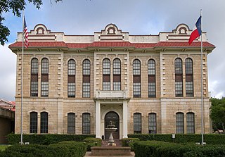
Robertson County is a county located in the U.S. state of Texas. As of the 2010 census, its population was 16,622. Its county seat is Franklin. The county was created in 1837 and organized the following year. It is named for Sterling C. Robertson, an early settler who signed the Texas Declaration of Independence.

The Texas Blackland Prairies are a temperate grassland ecoregion located in Texas that runs roughly 300 miles (480 km) from the Red River in North Texas to San Antonio in the south. The prairie was named after its rich, dark soil.
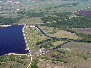
The Shellmouth Reservoir is a man-made reservoir on the Assiniboine River in Manitoba and Saskatchewan, Canada.
There are five county parks in Collin County, Texas.

Prairie Hill is an unincorporated community in Washington County, Texas, United States. Founded in 1870, the community flourished from the 1880s through to the 1960s and is still in existence today.

AirHogs Stadium is a stadium in Grand Prairie, Texas. It is primarily used for baseball as the home of the American Association's Texas AirHogs. It has a capacity of 5,445 people and opened in May 2008. In addition to baseball, it plays host to various other concerts and events throughout the year. For a period of time, it was known as QuikTrip Park due to the sponsorship by the convenience store chain. In 2015, the city of Grand Prairie paid off the debt to build the stadium.
Stella is a ghost town in western Fayette County, Texas. The community was located eight miles southwest of West Point.
Mullins Prairie is an unincorporated community in eastern Fayette County, Texas, United States.
Waldeck is an unincorporated community in northern Fayette County, Texas, United States. Originally known as Long Prairie, the town is predominantly German and was named after Count Ludwig Joseph von Boos-Waldeck who purchased lands in the area in 1843 on behalf of the Adelsverein.
Caney is an Unincorporated community in Matagorda County, Texas, United States.

Rabb is an unincorporated community in Nueces County, Texas, United States. It lies along the Texas Mexican Railway in the northwestern part of the county.
Mount Vernon is a hamlet in the town of Hamburg in Erie County, New York, United States. It is located within the Wanakah census-designated place and is part of the Frontier Central School District. The Hamlet is separate from the city of Mount Vernon, a city in Westchester County.
Sublime is an unincorporated community in Lavaca County, Texas, United States. Although it is unincorporated, Sublime has a post office, with the ZIP code of 77986.
Telferner is an unincorporated community in Victoria County, Texas, United States. According to the Handbook of Texas, the community had an estimated population of 700 in 2000. It is part of the Victoria, Texas, Metropolitan Statistical Area.
The Prairies and Pineywoods Wildlife Trail is a state-designated system of trails and wildlife sanctuaries in the Texas Panhandle in the United States. It is one of the four major wildlife trail systems designated by the State of Texas.
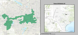
Texas's 33rd Congressional District is a new district that was created as a result of the 2010 Census. The first candidates ran in the 2012 House elections, and were seated for the 113th United States Congress.`
Decatur Rock is a small barren island located in Buzzards Bay in New Bedford, Massachusetts.
Bald Prairie is an unincorporated community in Robertson County, in the U.S. state of Texas.

Badger Grove is an unincorporated community in Prairie Township, White County, in the U.S. state of Indiana.


