Radkov (Opava District)

Last updated
Radkov
Radkov (OP), kostel.jpg
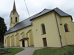
Church of the Nativity of the Virgin Mary
Vlajka obce Radkov u Opavy.gif
Radkov znak.jpg
Relief Map of Czech Republic.png
Red pog.svg
Radkov
Location in the Czech Republic
Coordinates: 49°49′32″N17°46′13″E / 49.82556°N 17.77028°E / 49.82556; 17.77028
CountryFlag of the Czech Republic.svg  Czech Republic
Region Moravian-Silesian Region
District Opava
First mentioned1377
Area
  Total
15.37 km2 (5.93 sq mi)
Elevation
474 m (1,555 ft)
Population
 (2025-01-01) [1]
  Total
494
  Density32/km2 (83/sq mi)
Time zone UTC+1 (CET)
  Summer (DST) UTC+2 (CEST)
Postal code
747 84
Website www.obecradkov.cz

Radkov (German : Ratkau) is a municipality and village in Opava District in the Moravian-Silesian Region of the Czech Republic. It has about 500 inhabitants.

Contents

History

The first written mention of Radkov is from 1377. [2]

Demographics

Historical population
YearPop.±%
18691,002    
18801,064+6.2%
18901,152+8.3%
19001,078−6.4%
19101,089+1.0%
19211,013−7.0%
1930957−5.5%
1950574−40.0%
1961669+16.6%
1970739+10.5%
1980588−20.4%
1991506−13.9%
2001508+0.4%
2011490−3.5%
2021501+2.2%
Source: Censuses [3] [4]

Notable people

References

  1. "Population of Municipalities – 1 January 2025". Czech Statistical Office. 2025-05-16.
  2. "Obec Radkov" (in Czech). Obec Radkov. Retrieved 2022-03-17.
  3. "Historický lexikon obcí České republiky 1869–2011" (in Czech). Czech Statistical Office. 2015-12-21.
  4. "Population Census 2021: Population by sex". Public Database. Czech Statistical Office. 2021-03-27.