
Budki is a village in the administrative district of Gmina Krzywda, within Łuków County, Lublin Voivodeship, in eastern Poland. It lies approximately 6 kilometres (4 mi) west of Krzywda, 23 km (14 mi) south-west of Łuków, and 69 km (43 mi) north-west of the regional capital Lublin.
Cisownik is a village in the administrative district of Gmina Krzywda, within Łuków County, Lublin Voivodeship, in eastern Poland. It lies approximately 7 kilometres (4 mi) west of Krzywda, 24 km (15 mi) south-west of Łuków, and 70 km (43 mi) north-west of the regional capital Lublin.
Feliksin is a village in the administrative district of Gmina Krzywda, within Łuków County, Lublin Voivodeship, in eastern Poland. It lies approximately 12 kilometres (7 mi) west of Krzywda, 28 km (17 mi) south-west of Łuków, and 72 km (45 mi) north-west of the regional capital Lublin.
Fiukówka is a village in the administrative district of Gmina Krzywda, within Łuków County, Lublin Voivodeship, in eastern Poland. It lies approximately 8 kilometres (5 mi) north-west of Krzywda, 20 km (12 mi) west of Łuków, and 74 km (46 mi) north-west of the regional capital Lublin.
Gołe Łazy is a village in the administrative district of Gmina Krzywda, within Łuków County, Lublin Voivodeship, in eastern Poland. It lies approximately 13 kilometres (8 mi) west of Krzywda, 29 km (18 mi) south-west of Łuków, and 73 km (45 mi) north-west of the regional capital Lublin.
Huta Radoryska is a village in the administrative district of Gmina Krzywda, within Łuków County, Lublin Voivodeship, in eastern Poland. It lies approximately 4 kilometres (2 mi) south-west of Krzywda, 22 km (14 mi) south-west of Łuków, and 67 km (42 mi) north-west of the regional capital Lublin.
Huta-Dąbrowa is a village in the administrative district of Gmina Krzywda, within Łuków County, Lublin Voivodeship, in eastern Poland. It lies approximately 11 kilometres (7 mi) west of Krzywda, 27 km (17 mi) south-west of Łuków, and 72 km (45 mi) north-west of the regional capital Lublin.
Kasyldów is a village in the administrative district of Gmina Krzywda, within Łuków County, Lublin Voivodeship, in eastern Poland. It lies approximately 11 kilometres (7 mi) north-west of Krzywda, 24 km (15 mi) south-west of Łuków, and 74 km (46 mi) north-west of the regional capital Lublin.
Kożuchówka is a village in the administrative district of Gmina Krzywda, within Łuków County, Lublin Voivodeship, in eastern Poland. It lies approximately 5 kilometres (3 mi) north of Krzywda, 16 km (10 mi) south-west of Łuków, and 70 km (43 mi) north of the regional capital Lublin.
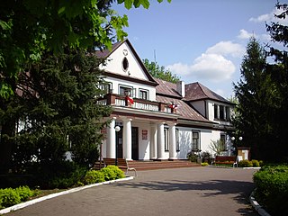
Krzywda is a village in Łuków County, Lublin Voivodeship, in eastern Poland. It is the seat of the gmina called Gmina Krzywda. It lies approximately 24 kilometres (15 mi) south-west of Łuków and 83 km (52 mi) north-west of the regional capital Lublin.
Laski is a village in the administrative district of Gmina Krzywda, within Łuków County, Lublin Voivodeship, in eastern Poland. It lies approximately 9 kilometres (6 mi) west of Krzywda, 24 km (15 mi) south-west of Łuków, and 72 km (45 mi) north-west of the regional capital Lublin.
Okrzeja is a village in the administrative district of Gmina Krzywda, within Łuków County, Lublin Voivodeship, in eastern Poland. It lies approximately 8 kilometres (5 mi) south-west of Krzywda, 26 km (16 mi) south-west of Łuków, and 64 km (40 mi) north-west of the regional capital Lublin.
Podosie is a village in the administrative district of Gmina Krzywda, within Łuków County, Lublin Voivodeship, in eastern Poland. It lies approximately 12 kilometres (7 mi) west of Krzywda, 27 km (17 mi) south-west of Łuków, and 74 km (46 mi) north-west of the regional capital Lublin.

Radoryż Kościelny is a village in the administrative district of Gmina Krzywda, within Łuków County, Lublin Voivodeship, in eastern Poland. It lies approximately 4 kilometres (2 mi) west of Krzywda, 21 km (13 mi) south-west of Łuków, and 68 km (42 mi) north-west of the regional capital Lublin.
Ruda is a village in the administrative district of Gmina Krzywda, within Łuków County, Lublin Voivodeship, in eastern Poland. It lies approximately 4 kilometres (2 mi) north-east of Krzywda, 16 km (10 mi) south-west of Łuków, and 68 km (42 mi) north of the regional capital Lublin.
Szczałb is a village in the administrative district of Gmina Krzywda, within Łuków County, Lublin Voivodeship, in eastern Poland. It lies approximately 4 kilometres (2 mi) south-east of Krzywda, 18 km (11 mi) south-west of Łuków, and 64 km (40 mi) north of the regional capital Lublin.
Teodorów is a village in the administrative district of Gmina Krzywda, within Łuków County, Lublin Voivodeship, in eastern Poland. It lies approximately 10 kilometres (6 mi) west of Krzywda, 25 km (16 mi) south-west of Łuków, and 74 km (46 mi) north-west of the regional capital Lublin.
Wielgolas is a village in the administrative district of Gmina Krzywda, within Łuków County, Lublin Voivodeship, in eastern Poland. It lies approximately 7 kilometres (4 mi) north-west of Krzywda, 20 km (12 mi) south-west of Łuków, and 72 km (45 mi) north-west of the regional capital Lublin.
Wola Okrzejska is a village in the administrative district of Gmina Krzywda, within Łuków County, Lublin Voivodeship, in eastern Poland. It lies approximately 8 kilometres (5 mi) south-west of Krzywda, 26 km (16 mi) south-west of Łuków, and 64 km (40 mi) north-west of the regional capital Lublin.
Zimna Woda is a village in the administrative district of Gmina Krzywda, within Łuków County, Lublin Voivodeship, in eastern Poland. It lies approximately 4 kilometres (2 mi) east of Krzywda, 16 km (10 mi) south-west of Łuków, and 66 km (41 mi) north of the regional capital Lublin.


