
Boulder Glacier is located on the southeast slope of Mount Baker, a stratovolcano near the Pacific coast of North America in the Cascade Range of Washington. Boulder Glacier is the sixth largest on Mount Baker with an area of 1.3 square miles (3.4 km2). It flows from the summit crater between Grant Peak and Sherman Peak to about 5,000 ft (1,500 m). It is noteworthy for retreating 1,610 ft (490 m) between 1987 and 2008, leaving newly exposed rock and soil behind.

Lower Curtis Glacier is in North Cascades National Park in the U.S. state of Washington. Named for photographer Asahel Curtis, the glacier is in a cirque on the western slopes of Mount Shuksan. Lower Curtis Glacier is rapidly retreating and has a negative mass balance, meaning that the rate of snow and ice that is falling in the accumulation zone is less than that which is lost each year in the ablation zone. Between 1908 and 1984, the glacier experienced a loss of thickness by 45 meters (147 ft). Between 1984 and 2002, the glacier lost another 6 meters (19 ft) in thickness. Lower Curtis Glacier also lost 28% of its surface area between the end of the little ice age and 1950. Between the years 1951 and 1979, the glacier actually lengthened by 245 meters (800 ft) but has retreated 184 m (600 ft) since 1985, partly due to the tongue of the glacier being on a steep precipice which may have increased the loss of ice at the termini.

Coleman Glacier is located on Mount Baker in the North Cascades of the U.S. state of Washington. Between 1850 and 1950, Coleman Glacier retreated 8,200 ft (2,500 m). During a cooler and wetter period from 1950 to 1979, the glacier advanced 2,480 ft (760 m) but between 1980 and 2006 retreated back 1,443 ft (440 m). Situated on the west slopes of Mount Baker, Coleman Glacier is bordered by the Roosevelt Glacier to the north and the Heliotrope Ridge to the south.

Blue Glacier is a large glacier located to the north of Mount Olympus in the Olympic Mountains of Washington. The glacier covers an area of 1.7 sq mi (4.4 km2) and contains 580,000,000 cu ft (16,000,000 m3) of ice and snow in spite of its low terminus elevation. The glacier length has decreased from about 3.4 mi (5.5 km) in 1800 to 2.7 mi (4.3 km) in the year 2000. Just in the period from 1995 and 2006, Blue Glacier retreated 325 ft (99 m). Blue Glacier is also thinning as it retreats and between 1987 and 2009 the glacier lost 178 ft (54 m) of its depth near its terminus and between 32 and 48 ft in the uppermost sections of the glacier known as the accumulation zone.

Easton Glacier is one of the more prominent alpine glaciers on Mount Baker in the North Cascades of Washington state, United States. Named for Charles F. Easton of Bellingham, who did much to preserve the history of Mount Baker, it is positioned on the south face of the mountain and flanked by Squak and Deming Glaciers.

Coe Glacier is in the U.S. state of Oregon. The glacier is situated in the Cascade Range on the north slope of Mount Hood, at an elevation between 10,500 and 6,400 ft.

Deming Glacier is located on Mount Baker in the North Cascades of the U.S. state of Washington. Between 1850 and 1950, Deming Glacier retreated 7,217 ft (2,200 m). During a cooler and wetter period from 1950 to 1979, the glacier advanced 2,060 ft (630 m) but between 1980 and 2006 retreated back 1,140 ft (350 m). Situated on the southwest slopes of Mount Baker, Deming Glacier is bordered by the Easton Glacier to the east and the Black Buttes ridge to the west.
Mazama Glacier is located on Mount Baker in the North Cascades of the U.S. state of Washington. Between 1850 and 1950, Mazama Glacier retreated 7,700 ft (2,300 m). During a cooler and wetter period from 1950 to 1979, the glacier advanced 1,476 ft (450 m) but between 1980 and 2006 retreated back 1,509 ft (460 m). Situated on the north slopes of Mount Baker, Mazama Glacier is bordered by the Park Glacier to the south and Rainbow Glacier to the east.
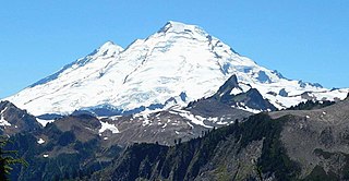
Park Glacier is located on the northeast slopes of Mount Baker in the North Cascades of the U.S. state of Washington. Park Glacier descends to the Park Cliffs along its eastern margin while the northern tongue of the glacier descends to nearly 4,500 ft (1,400 m) and is below Park Cliffs and Lava Divide. In the middle of its course, Park Glacier is connected to Rainbow Glacier to the north and Boulder Glacier to the south.

Roosevelt Glacier is located on the north slopes of Mount Baker in the North Cascades of the U.S. state of Washington. Roosevelt Glacier descends to nearly 5,000 ft (1,500 m) at Chromatic Moraine. In the middle of its course, Roosevelt Glacier is connected to Coleman Glacier to its south.
Sholes Glacier is located on the northeast slopes of Mount Baker in the North Cascades of the U.S. state of Washington. The glacier lies on the north side of the ridge known as The Portals. Between 1850 and 1950, Sholes Glacier retreated 3,838 ft (1,170 m). During a cooler and wetter period from 1950 to 1979, the glacier advanced 187 ft (57 m) but between 1980 and 2006 retreated back 278 ft (85 m).
Squak Glacier is located on the southeast slopes of Mount Baker in the North Cascades of the U.S. state of Washington. Squak Glacier is connected to Easton Glacier to the east and Talum Glaciers to the west. Between 1850 and 1950, Squak Glacier retreated 8,202 ft (2,500 m). During a cooler and wetter period from 1950 to 1979, the glacier advanced 305 ft (93 m) but between 1980 and 2006 retreated back 869 ft (265 m).
The Talum Glaciers are located on the southeast slopes of Mount Baker in the North Cascades of the U.S. state of Washington. The glaciers are connected to Squak Glacier to the west. Between 1850 and 1950, the Talum Glaciers retreated 6,479 ft (1,975 m). During a cooler and wetter period from 1950 to 1979, the glaciers advanced 902 ft (275 m) but between 1980 and 2006 retreated back 951 ft (290 m).

Chocolate Glacier is located on east slopes of Glacier Peak in the U.S. state of Washington. The glacier descends from 10,400 ft (3,200 m) to 5,900 ft (1,800 m) and is partially connected to Cool Glacier which lies to its south just below the summit of Glacier Peak. As is true with all the glaciers found on Glacier Peak, Chocolate Glacier is retreating. Chocolate Glacier retreated approximately 1,380 m (4,530 ft) between 1906 and 1946, however during a cooler and wetter period from about 1950 to 1979, the glacier advanced 450 m (1,480 ft). Chocolate Glacier has resumed retreating since and has given back 350 m (1,150 ft), nearing its previously recorded minimal length. The current terminus at 1800 m is still the lowest of the east side glacier. Chocolate Glacier remains heavily crevassed and active to 1900 m. The lowest 300 m of the glacier are stagnant.

Cool Glacier is located on east slopes of Glacier Peak in the U.S. state of Washington. The glacier descends from 10,200 ft (3,100 m) to 6,900 ft (2,100 m) and is partially connected to Chocolate Glacier which lies to its north just below the summit of Glacier Peak. As is true with all the glaciers found on Glacier Peak, Cool Glacier is retreating. Cool Glacier retreated approximately 1,500 m (4,900 ft) between 1850 and 1946, however during a cooler and wetter period from about 1950 to 1979, the glacier advanced. Since then Cool Glacier resumed retreating and by 2005 the glacier was within 40 m (130 ft) of its minimum length recorded in 1946.
North Guardian Glacier is located on east slopes of Glacier Peak in the U.S. state of Washington. The glacier descends from 8,600 ft (2,600 m) to 6,430 ft (1,960 m) and is partially connected to Chocolate Glacier which lies to its south. As is true with all the glaciers found on Glacier Peak, North Guardian Glacier is retreating. North Guardian Glacier retreated approximately 1,500 m (4,900 ft) between 1850 and 1946, however during a cooler and wetter period from about 1950 to 1979, the glacier advanced modestly. Since then North Guardian Glacier resumed retreating and thinning and by 2005 the glacier had returned to its minimum length as recorded in 1946.
Suiattle Glacier is located in the Glacier Peak Wilderness in the U.S. state of Washington. The glacier is within Mount Baker-Snoqualmie National Forest and nearly touches Honeycomb and White River glaciers separated from them by an arête off the Kololo Peaks at its uppermost reaches. Suiattle Glacier has retreated significantly since the end of the Little Ice Age, and from approximately the years 1850 to 1924 lost 1,400 m (4,600 ft) of its length. Between 1924 and 1940, the glacier retreated an additional 900 m (3,000 ft), then during a cooler and wetter period between 1967 and 1979, the glacier had a small advance of 20 m (66 ft). Between 1979 and 2005 the glacier again retreated 178 m (584 ft) upslope.
Daniel Glacier is in Wenatchee National Forest in the U.S. state of Washington and is on the north slope of Mount Daniel. Daniel Glacier retreated almost 500 m (1,600 ft) between 1950 and 2005. Daniel Glacier is separated from Lynch Glacier to the west by a ridge.
Foss Glacier is within the Alpine Lakes Wilderness of Snoqualmie National Forest in the U.S. state of Washington and is on the northeast slope of Mount Hinman. Foss Glacier retreated almost 500 m (1,600 ft) between 1950 and 2005. Foss Glacier is separated from the nearly vanished Hinman Glacier to the west by a ridge.
Watson Glacier is in Snoqualmie National Forest in the U.S. state of Washington, on the north slope of Mount Watson. Watson Glacier retreated 430 ft (130 m) between 1950 and 2007 and is now only 1,150 ft (350 m) in length. Watson Glacier descends from 6,000 to 5,700 ft.


