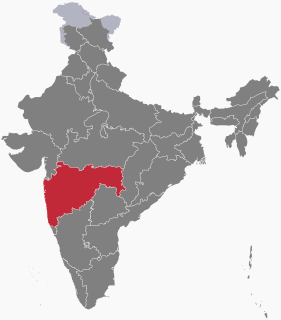
Vidarbha is the eastern region of the Indian state of Maharashtra, comprising Nagpur Division and Amravati Division. Amravati division's former name is Berar. It occupies 31.6% of the total area and holds 21.3% of the total population of Maharashtra. It borders the state of Madhya Pradesh to the north, Chhattisgarh to the east, Telangana to the south and Marathwada and Khandesh regions of Maharashtra to the west. Situated in central India, Vidarbha has its own rich cultural and historical background distinct from rest of Maharashtra. The largest city in Vidarbha is Nagpur followed by Amravati. A majority of Vidarbhians speak Varhadi and Zadi dialects of Marathi.

Bombay State was a large Indian state created at the time of India's Independence, with other regions being added to it in the succeeding years. Bombay Presidency was merged with the princely states of the Baroda, Western India and Gujarat and Deccan States (which included parts of the present-day Indian states of Maharashtra and Karnataka.

Berar Province, also known as the Hyderabad Assigned Districts, was a province of British India. The province was ruled by the Nizam of Hyderabad, but after 1853, it was administered by the British, although the Nizam retained formal sovereignty over the province. Azam Jah, the eldest son of the 7th Nizam, held the title of Mirza-Baig ("Prince") of Berar.

The Raj Bhavan, formerly known during British India as the Bangalore Residency, the Mysore State Residency, or, simply, the Residency, is the official residence of the Governor of Karnataka. It is located in the capital city of Bangalore, Karnataka. During Mysore Kingdom, the building was home to the Resident of the British Agency that was in subsidiary alliance with the Kingdom of Mysore.
Raj Bhavan is the official residence of the Governor of Maharashtra. It is located in the capital city of Mumbai, Maharashtra on Malabar Hill. The Raj Bhavan is located in 50 acres (200,000 m2) of sylvan surroundings, surrounded on three sides by the sea. The estate has several heritage bungalows, trees, large lawns and a beach.

Amravati division also known as Varhad is one of the six administrative divisions of Maharashtra state in India. Amravati and Nagpur divisions constitute the ancient Vidarbha region. Amravati Division is bound by Madhya Pradesh state to the north, Nagpur Division to the east, Telangana state to the southeast, Marathwada region to the south and southwest, and Nashik Division to the west.

Nagpur Province was a province of British India that covered parts of the present-day states of Madhya Pradesh, Maharashtra, and Chhattisgarh. The city of Nagpur was the capital of the province.

Nagpur district is a district in the Vidarbha region of Maharashtra state in central India. The city of Nagpur is the district administrative centre. The district is part of Nagpur Division.

The Kingdom of Nagpur was a kingdom in east-central India founded by the Gond rulers of Deogarh in the early 18th century. It came under the rule of the Marathas of the Bhonsale dynasty in the mid-18th century and became part of the Maratha Empire. The city of Nagpur was the capital of the state.
Raj Bhavan is the official residence of the Governor of Jharkhand. It is located in the capital city of Ranchi, Jharkhand. The present governor of Jharkhand is Draupadi Murmu.
Raj Bhavan is the official residence of the Governor of Madhya Pradesh. It is located in the capital city of Bhopal, Madhya Pradesh.

Nagpur Municipal Corporation is the municipal body administering Nagpur, in Maharashtra state in Central India.
The Berar Division, formerly Berar Province, was one of the former administrative divisions of the Central Provinces and Berar of British India. Ellichpur (Achalpur) was the capital and the administrative headquarters of the division.
Nagpur Improvement Trust (NIT)(Marathi: नागपूर सुधार प्रन्यास [नासुप्र]) is a local civic government body with the task of developing new areas within city limits of Nagpur, India and maintaining existing city infrastructure. Trust works along with Nagpur Municipal Corporation (NMC) which is an elected body of city representatives (Corporation). NIT itself is not a democratically elected civic body and has members appointed in it from various levels like Government of Maharashtra, NMC and other representatives of Nagpur city. NIT thus has a small management body as compared to NMC. NIT holds the planning and development authority for Nagpur city but does not receive any funds from state government. Funds needed for development work are raised by NIT through the auction of newly developed areas.

The Foundation year of NAGPUR is the year of 1702 . The history of Nagpur, in central India, spans over 5,000 years, including the Kingdom of Nagpur in the 18th and 19th century. Human existence around present-day Nagpur city can be traced back 3,000 years to the 8th century BC. Menhir burial sites at Drugdhamna indicate megalithic culture existed around Nagpur and is still followed in present times.
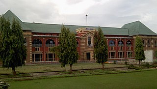
Vidhan Bhavan, Nagpur is the building in the Civil lines locality of Nagpur, the second capital of Maharashtra state of India, where Winter Session of the Maharashtra Legislature is held. The foundation stone of the building was laid in 1912. It was constructed by the then British command to house the administration of the Central Provinces and Berar, of which Nagpur was the capital. Later, in 1952, the CP & Berar was divided into the large central Indian state of Madhya Pradesh which included the current Madhya Pradesh, Chhattisgarh and Vidarbha regions. Nagpur was the capital of this state. In 1960, this state was further divided, with the Vidarbha region going to Maharashtra state with much resistance from the natives. Thus, Nagpur lost its capital status. But, a Nagpur Pact was signed by the Maharashtra state govt. headed by Yashwantrao Chavan to protect the interests and equal development of the Vidarbha region. Accordingly, Nagpur was made the second capital of the Maharashtra and the winter session of the state legislature and the state legislative council was to be held at Nagpur.