
Hisar also known as Hissar is the administrative headquarters of Hisar district in the state of Haryana in northwestern India. It is located 164 km (102 mi) to the west of New Delhi, India's capital, and has been identified as a counter-magnet city for the National Capital Region to develop as an alternative center of growth to Delhi.

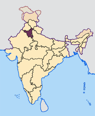
Hisar district is one of the 22 districts of Haryana, India. Hisar city serves as the district headquarters. Hisar district has four sub-divisions that is, Hisar, Barwala, Hansi and Narnaud, each headed by an SDM. The district is also part of Hisar division. Hisar was founded by Firuz Shah Tughlaq.

Hansi, is a city and municipal council in Hisar district in the Indian state of Haryana. It appears that at one time Hansi was larger, more prosperous and more important than Hisar. The town has several important buildings of archeological importance.

Fatehabad district is one of the twenty two districts of the state of Haryana, India. Fatehabad was founded by Firuz Shah Tughlaq. Fatehabad district was carved out of Hisar district on 15 July 1997.
Nalwa is a village, as well as an Assembly Constituency in Haryana Legislative Assembly, located in Hisar district in the state of Haryana in India.
Tohana is a city and a municipal council, just 56 km from Fatehabad City in Fatehabad district in the Indian state of Haryana. Its name comes from the Sanskrit 'Taushayana'. It is known as the City of Canals.
Kanwari, also spelled Kunwari, or Kwari, is a village of 7,000 population, in Hansi-I Tehsil, Hisar-1 Rural Development Block, Hansi and Hisar of Hisar District of Hisar Division in the Haryana state of India. It is part of the saat bas bhaichara grouping of 7 villages. The village has 4 panna/patti (subdivisions), named as Nangalia Panna , upparla Panna , parla Panna , etc. with a total revenue land area of 43903 kanal or 5487 acre as per HALRIS records.
Datta is a village in Hansi Tehsil, Hisar district, in Haryana, India. It is situated 36 km from Hisar city and 20 km from Hansi city on the road which also leads to Barwala. At Data there is another road that leads to Narnaund. It is 15 km from Narnaund Tehsil and only 16 km from Barwala town. Datta comes under Roghi Khap Panchayat. There is an oil depot of HPCL situated on Bianakhera road.
Kaimri is a village in Hisar tehsil and district in the Indian state of Haryana.
Dhamana is a village in Hansi-I mandal of the Hisar district, in the Indian state of Haryana. It is in between the towns of Hisar and Tosham at about 20 kilometres (12 mi) on the Main District Road 108. Dhamana is fifth village on Hisar-Tosam road, first is Dabra, Second is Mirkan, Third is Bhojraj, Four is Gunjar. Then Fifth is Dhamana. This village is also known as village of Ahir's peoples.

The following outline is provided as an overview of and topical guide to Haryana.
Hisar Urban Agglomeration is an extended area of the city of Hisar which includes the area under the Municipal Corporation of Hisar and the campus of Chaudhary Charan Singh Haryana Agricultural University along with the Mini Secretariat. It is the second biggest urban agglomeration in Haryana after Faridabad.
Mahavir Stadium, built in 1972, is a multipurpose sports complex located in Hisar city of Haryana, India. It has second largest capacity in Haryana, after the Shah Satnam Ji Cricket Stadium in Sirsa which has capacity of 35,000 spectators. It is owned and operated by the District Olympic Association of Hisar. The venue is used for several events, such as cricket and football.
Hisar Airport, officially known as Maharaja Agrasen International Airport is a DGCA-licensed public airport serving Hisar in Haryana state of India. It is located 5 kilometres (3.1 mi) northeast of the city center on NH-9. The airport is planned to be upgraded to an international airport by 2030. It will eventually see the development of a new MRO, aerospace university, aerospace and defense manufacturing industrial zone, logistics and food parks, etc. over an area spread across 10,000 acres (4,000 ha). In 2021, the total cost of planned upgrade in 3 phases, including the actual spend and future approved allocations, is nearly ₹5,200 crore.
Bhiwani Aerodrome, also called Bhiwani Air Strip, is a public civil aerodrome adjacent to Gujrani village in the Bhiwani district of the Indian state of Haryana.
Dhatrath is a village in Safidon, Jind district at Haryana, India. It belongs to Hisar Division. It is located 16 km from Jind and about 180 km from state capital Chandigarh. Pin code is 126110. Dhatrath is a very old village and also known as Seharda.
Sundawas is a village in Hisar tehsil and district in the Indian state of Haryana. Sundawas is located on Balsamad Road via Siswala around 24 KM away from District center Hisar (city). Village is located near to eastern border of Rajasthan just distance of 10 K.M. It is last village on Haryana side with fertile black soil.

Johwa Hisar is a village in Harchandpur block of Rae Bareli district, Uttar Pradesh, India. It is located 38 km from Raebareli, the district headquarters. As of 2011, its population is 1,692, in 372 households. It has one primary school and no healthcare facilities.

