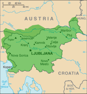
Vodice is a settlement in the Municipality of Vodice in the Upper Carniola region of Slovenia, just north of Ljubljana. In addition to the main population center of Vodice, the settlement includes the hamlets of Gornji Konec, Na Vasi, Lokarje, Jegriše, Mesto, Zaprice, and Pusence.

Brezovica pri Stopičah is a settlement in the Municipality of Novo Mesto in southeastern Slovenia. The entire municipality is part of the traditional region of Lower Carniola and is now included in the Southeast Slovenia Statistical Region.

Črmošnjice pri Stopičah is a settlement south of Novo Mesto in southeastern Slovenia. The entire municipality of Novo Mesto lies in the traditional region of Lower Carniola and is now included in the Southeast Slovenia Statistical Region.

Jelše pri Otočcu is a small settlement east of Otočec in the Municipality of Novo Mesto in southeastern Slovenia. The area is part of the traditional region of Lower Carniola and is now included in the Southeast Slovenia Statistical Region.

Sela pri Zajčjem Vrhu is a settlement in the foothills of the Gorjanci range in the Municipality of Novo Mesto in southeastern Slovenia. The area is part of the traditional region of Lower Carniola and is now included in the Southeast Slovenia Statistical Region.

Sela pri Štravberku is a small settlement in the hills north of Novo Mesto in southeastern Slovenia. The area is part of the traditional region of Lower Carniola and is now included in the Southeast Slovenia Statistical Region.

Škrjanče pri Novem Mestu is a settlement in the hills to the southwest of Novo Mesto in southeastern Slovenia. The area is part of the traditional region of Lower Carniola and is now included in the Southeast Slovenia Statistical Region.

Trška Gora is a settlement in the hills north of Novo Mesto in southeastern Slovenia. The area is part of the traditional region of Lower Carniola and is now included in the Southeast Slovenia Statistical Region.

Zajčji Vrh pri Stopičah is a settlement in the foothills of the Gorjanci range in the Municipality of Novo Mesto in southeastern Slovenia. The area is part of the traditional region of Lower Carniola and is now included in the Southeast Slovenia Statistical Region.

Gorenje Kamence is a settlement north of the town of Novo Mesto in southeastern Slovenia. The entire Municipality of Novo Mesto is part of the traditional region of Lower Carniola and is now included in the Southeast Slovenia Statistical Region.

Hrib pri Orehku is a settlement in the hills southeast of Novo Mesto in southeastern Slovenia. The area is part of the traditional region of Lower Carniola and is now included in the Southeast Slovenia Statistical Region.

Sela pri Ratežu is a settlement in the hills east of Novo Mesto in southeastern Slovenia. The area is part of the traditional region of Lower Carniola and is now included in the Southeast Slovenia Statistical Region.

Vrh pri Ljubnu is a settlement in the hills southwest of Novo Mesto in southeastern Slovenia. The area is part of the traditional region of Lower Carniola and is now included in the Southeast Slovenia Statistical Region.

Vrh pri Pahi is a small settlement in the hills north of Otočec in the Municipality of Novo Mesto in southeastern Slovenia. The area is part of the traditional region of Lower Carniola and is now included in the Southeast Slovenia Statistical Region.

Vrhe is a small settlement in the Gorjanci Hills in the Municipality of Novo Mesto in southeastern Slovenia. The area is part of the traditional region of Lower Carniola and is now included in the Southeast Slovenia Statistical Region.

Zagrad pri Otočcu is a small settlement in the hills north of Otočec in the Municipality of Novo Mesto in southeastern Slovenia. The area is part of the traditional region of Lower Carniola and is now included in the Southeast Slovenia Statistical Region.

Rakovnik pri Šentrupertu is a village in the Municipality of Šentrupert in southeastern Slovenia. It lies south of Šentrupert and east of Mirna in the historical region of Lower Carniola. The railway line from Sevnica to Trebnje runs across the settlement's territory. The Municipality of Šentrupert is now included in the Southeast Slovenia Statistical Region.

Breg pri Temenici is a settlement on the right bank of the Temenica River in the Municipality of Ivančna Gorica in central Slovenia. The railway line from Ljubljana to Novo Mesto runs just south of the settlement. The area is part of the historical region of Lower Carniola. The municipality is now included in the Central Slovenia Statistical Region.

The Municipality of Škocjan, established in October 1994, is a municipality in the traditional region of Lower Carniola in southeastern Slovenia. The seat of the municipality is Škocjan. The Municipality of Škocjan is now included in the Southeast Slovenia Statistical Region. The majority of the municipality is part of the Novo Mesto Administrative Unit, except for the northeastern part, which belongs to the Sevnica Administrative Unit.


