
Michigan City Municipal Airport is a public use airport located three nautical miles east of the central business district of Michigan City, in LaPorte County, Indiana, United States. The airport is publicly owned by the Michigan City Board of Aviation Commissioners.

Fitch H. Beach Airport is a city-owned, public-use airport located two nautical miles (3.7 km) northeast of the central business district of Charlotte, a city in Eaton County, Michigan, United States. It is included in the Federal Aviation Administration (FAA) National Plan of Integrated Airport Systems for 2017–2021, in which it is categorized as a local general aviation facility.
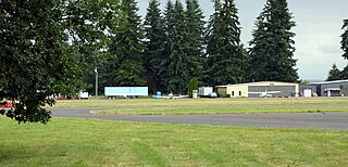
Scappoose Industrial Airpark is a public use airport located one nautical mile (1.85 km) northeast of the central business district of Scappoose, in Columbia County, Oregon, United States. It is owned and operated by the Port of Columbia County, an Oregon port district and municipal corporation, on behalf of district residents. According to the FAA's National Plan of Integrated Airport Systems for 2009–2013, it is categorized as a general aviation airport.

Tillamook Airport is a public use airport located 3 miles (4.8 km) south of the central business district of Tillamook, a city in Tillamook County, Oregon, United States. It is owned by the Port of Tillamook Bay. According to the FAA's National Plan of Integrated Airport Systems for 2009–2013, it is categorized as a general aviation facility.

Elkhart Municipal Airport is a city-owned public-use airport located three nautical miles (6 km) northwest of the central business district of Elkhart, a city in Elkhart County, Indiana, United States.

Clark Regional Airport is a public use airport in Clark County, Indiana, United States. The airport is owned by the South Central Regional Airport Authority. It is located five nautical miles (9 km) north of the central business district of Jeffersonville, Indiana, in the town of Sellersburg. It is also seven miles (11 km) north of Louisville.
Eagle Creek Airpark is a public use airport located seven nautical miles (13 km) west of the central business district of Indianapolis, a city in Marion County, Indiana, United States. It is owned by the Indianapolis Airport Authority and serves as a reliever airport for Indianapolis International Airport.

Weedon Field is a city-owned, public-use airport located three nautical miles north of the central business district of Eufaula, a city in Barbour County, Alabama, United States.
Virgil I. Grissom Municipal Airport is a public use airport located three nautical miles southeast of the central business district of Bedford, a city in Lawrence County, Indiana, United States.
French Lick Municipal Airport is a city-owned public-use airport located three nautical miles southwest of the central business district of French Lick, a town in Orange County, Indiana, United States. Also known as French Lick Airport, it serves the French Lick and West Baden, Indiana area.
Shelbyville Municipal Airport is a public use airport located four nautical miles (7 km) northwest of the central business district of Shelbyville, in Shelby County, Indiana, United States. The airport is owned by the city of Shelbyville and is controlled by the mayor and an appointed Board of Commissioners. According to the FAA's National Plan of Integrated Airport Systems for 2009–2013, it was classified as a general aviation airport.
Chester Catawba Regional Airport is a county-owned public-use airport located five nautical miles (9 km) north of the central business district of Chester, a city in Chester County, South Carolina, United States. The airport is technically a "regional" airport, but the airport does not have a scheduled air service; it is mainly for the use of private aircraft for residents of Chester County. According to the FAA's National Plan of Integrated Airport Systems for 2009–2013, it is categorized as a general aviation facility.
Pam's Place Airport is a public-use airport in Putnam County, Indiana, United States. It is located three nautical miles (6 km) southwest of the central business district of Eminence, an unincorporated town in Adams Township, Morgan County.
Boonville Airport is a city-owned, public-use airport located two nautical miles west of the central business district of Boonville, a city in Warrick County, Indiana, United States.
Lost Creek Airport is a public use airport located three nautical miles (6 km) northeast of the central business district of Luzerne, in Oscoda County, Michigan, United States. It is owned by the U.S. Department of Agriculture.
Mettel Field is a public airport three miles north of Connersville, in Fayette County, Indiana. It is owned by the Connersville Board of Aviation Commissioners. The National Plan of Integrated Airport Systems for 2011–2015 categorized it as a general aviation facility.
Goshen Municipal Airport is a public use airport located three nautical miles (6 km) southeast of the central business district of Goshen, a city in Elkhart County, Indiana, United States. It is owned by the Goshen Board of Aviation Commissioners. This airport is included in the National Plan of Integrated Airport Systems for 2011–2015, which categorized it as a general aviation facility.
Richmond Municipal Airport is six miles southeast of Richmond, in Wayne County, Indiana. It is owned by the Richmond Board of Aviation Commissioners. The National Plan of Integrated Airport Systems for 2011–2015 called it a general aviation facility.
Huntingburg Airport is a public use airport located three nautical miles (6 km) south of the central business district of Huntingburg, a city in Dubois County, Indiana, United States. It is owned by the Dubois County Airport Authority. This airport is included in the National Plan of Integrated Airport Systems for 2011–2015, which categorized it as a general aviation facility.
White County Airport is a public use airport in White County, Indiana, United States. It is owned by the White County Board of Aviation Commissioners and located three nautical miles (6 km) south of the central business district of Monticello, Indiana. This airport is included in the National Plan of Integrated Airport Systems for 2011–2015, which categorized it as a general aviation facility.


