This article needs additional citations for verification .(January 2019) |
Ramanamudalipudur is a town situated in Coimbatore rural district, in the state of Tamil Nadu, India.
This article needs additional citations for verification .(January 2019) |
Ramanamudalipudur is a town situated in Coimbatore rural district, in the state of Tamil Nadu, India.
The town of Ramanamudalipudur exists near an abundant supply of wildlife. Animals like panthers, crocodiles, tigers, elephants, spotted deer, civet cats, and wild boars are found in the region. Numerous birds can also be sighted in the area. It is possible to spot such birds as the Malabar pied hornbill, black headed oriole, rocket-tailed drongo, tree pie, spotted dove, and red whiskered bulbul. In fact, the very name of this town invokes thoughts of wildlife, since the name's translation means elephant hill.
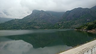
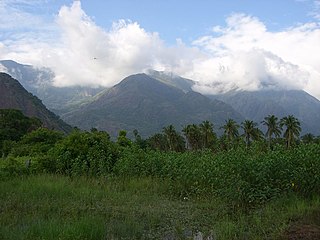
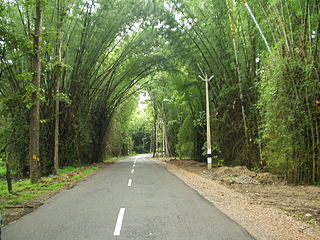
Located in the Coimbatore Hills district in the state of Tamil Nadu, the biggest draw for tourists in this area is the remarkable beauty of the natural landscape that is there. Many different shades of green make up the dense forest of this area. The town itself also has some incredibly interesting history.
Ramanamudalipudur is one of the eight sacred Jaina hills. Right by the village there is a natural cavern that contains numerous berths that are located both inside and outside of it. There is a Brahmi inscription on the outside wall that is dated back to the 1st or 2nd century. This inscription states that the berths were gifts from Nathan of Kunrattur made in honor of three monks named Eri Aritan, Attuvay, and Arrattakayipan. This is a rather unusual find since this village was not known for being a lama center until the 9th century. It was around that time that several stone sculptures started to be carved into the rocks by devout local people
Ramanamudalipudur climate is quite moderate.
Summers (March to May) are bit hot with maximum temperature lies between 35 °C to 40 °C. However, this season is good for exploring the forest wildlife. Monsoons [June to September] are accompanied with medium to heavy rainfalls owing to southwest and northeast monsoons. Post-monsoons [October to November] offer maximum rainfalls in Ramanamudalipudur, the forests looks beautiful during rainy seasons. Winters (December to February) have an average temperature of about 20 °C, with minimum not going below 15 °C.
Best season to visit Ramanamudalipudur is June to March, tourists may avoid heavy rainy days.
There are many temples in Ramanamudalipudur [1]
Bus service is available from Pollachi to Ramanamudalipudur. They are S. B. S 17 & CTC 17.
| Name | Position |
|---|---|
| R.S. Thangavel | Ex.MLA (VALPARAI) 1977-1980 |
| Name | Position |
|---|---|
| V.Kasthoori Vasu | Union Chairman |
| R.M. Papathi | Ex Union Chairman |
Panchayath Details
| Name | Position |
|---|---|
| M.Dhanabakiyam | Panchayath President |
| R.U.Saravanan | Vice president |
Details of Ex.Panchayath President
| Sno | Name |
|---|---|
| 1 | M.Arumugasamy Chettiyar |
| 2 | R.K.Rangasamy Chettiyar |
| 3 | V.Kasturi Vasu |
| 4 | R.M.Pappathi |

Ooty, abbreviated as Udagai) is a town and municipality in the Nilgiris district of the Indian state of Tamil Nadu. It is located 86 km (53 mi) northwest of Coimbatore, and is the headquarters of Nilgiris district. Situated in the Nilgiri hills, it is known by the epithet "Queen of Hill Stations", and is a popular tourist destination.

The Nilgiris district is one of the 38 districts in the southern Indian state of Tamil Nadu. Nilgiri is the name given to a range of mountains spread across the borders among the states of Tamil Nadu, Karnataka and Kerala. The Nilgiri Hills are part of a larger mountain chain known as the Western Ghats. Their highest point is the mountain of Doddabetta, height 2,637 m. The district is contained mainly within the Nilgiri Mountains range. The administrative headquarters is located at Ooty. The district is bounded by Coimbatore to the south, Erode to the east, and Chamarajnagar district of Karnataka and Wayanad district of Kerala to the north. As it is located at the junction of three states, namely, Tamil Nadu, Kerala, and Karnataka, significant Malayali and Kannadiga populations reside in the district. Nilgiris district is known for natural mines of Gold, which is also seen in the other parts of Nilgiri Biosphere Reserve extended in the neighbouring states of Karnataka and Kerala too.

The South Western Ghats moist deciduous forests is an ecoregion in the Western Ghats of southern India with tropical and subtropical moist broadleaf forests. This biome covers the Nilgiri Hills between elevation of 250 and 1,000 m in Kerala, Karnataka and Tamil Nadu states.

Kodaikanal is a municipality and hill station in Dindigul district in the state of Tamil Nadu, India. It is situated at an altitude of 2,225 m (7,300 ft) in the Palani hills of the Western Ghats. Kodaikanal was established in 1845 to serve as a refuge from the high temperatures and tropical diseases during the summer in the plains. It is a popular tourist destination and is referred to as the "Princess of Hill stations" with much of the local economy is based on the hospitality industry serving tourism. As per the 2011 census, the city had a population of 36,501.
Sultan Bathery is a town and municipality in the Wayanad district of Kerala, India, near its borders with Tamil Nadu and Karnataka. Once known as a strategic location in the Malabar region, Sultan Bathery is the headquarters of the Sultan Bathery taluk.

The Palani Hills are a mountain range in the southern Indian states of Tamil Nadu and Kerala. The Palani Hills are an eastward extension of the Western Ghats ranges, which run parallel to the west coast of India. The Palani Hills adjoin with the high Anamalai range on the west and extend east into the plains of Tamil Nadu, covering an area of 2,068 square kilometres (798 sq mi). The highest part of the range is in the southwest, and reaches 1,800-2,500 metres elevation; the eastern extension of the range is made up of hills 1,000-1,500 m (3,281-4,921 ft) high.

The Anamala or Anaimalai, also known as the Elephant Mountains, are a range of mountains in the southern Western Ghats of central Kerala and span the border of western Tamil Nadu in Southern India. The name anamala is derived from the Malayalam word aana and the Tamil word yaanai, meaning elephant, or from tribal languages. Mala or Malai means 'mountain', and thus literally translatable as 'Elephant mountain'.
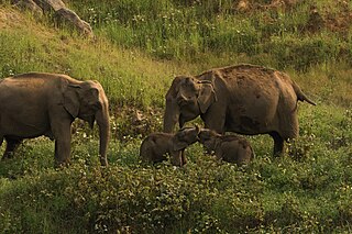
Anaimalai Tiger Reserve, earlier known as Indira Gandhi Wildlife Sanctuary and National Park and as Anaimalai Wildlife Sanctuary, is a protected area in the Anaimalai Hills of Pollachi and Valparai taluks of Coimbatore District and Udumalaipettai taluk in Tiruppur District, Tamil Nadu, India. The Tamil Nadu Environment and Forests Department by a notification dated 27 June 2007, declared an extent of 958.59 km2 that encompassed the erstwhile IGWLS&NP or Anaimalai Wildlife Sanctuary, as Anaimalai Tiger Reserve under the Wildlife Protection Act, 1972. According to the National Tiger Conservation Authority, the Reserve presently includes a core area of 958.59 km2 and buffer/peripheral area of 521.28 km2 forming a total area of 1479.87 km2.

Marayur or Marayoor is a town in Devikulam taluk of Idukki district in the southwestern Indian state of Kerala. It is located 42 kilometers north of Munnar on SH 17 connecting Munnar with Udumalpet, Tamil Nadu. Marayur is situated at around 990 metres above mean sea level and is the only place in Kerala that has natural sandalwood forests. Ancient dolmens and rock paintings in Marayur date back to the Stone Age. In 1991 Marayur had a population of 9,590.
Chikhaldara is a hill station and a municipal council in the Amravati district in the Indian state of Maharashtra.
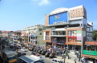
Pollachi is a town and municipality in Coimbatore district of the Indian state of Tamil Nadu. It is the administrative headquarters of Pollachi taluk. It is situated near the center of the South Indian Peninsula, surrounded by Western Ghats. Agriculture and textile industries contribute majorly to the economy of the town and the town is a popular marketplace for jaggery, vegetables and cattle.

Wellington is a town in the Nilgiris District of the Indian state of Tamil Nadu, located at three kilometres to the north of Coonoor on the NH-181. The town includes a Wellington Bazaar, and the Wellington Cantonment. The Wellington Cantonment is home to The Madras Regimental Centre (MRC) and The Defence Services Staff College (DSSC). The Nilgiri passenger train passes through Wellington, which also has a railway station.

Valparai is a Taluk and hill station in the Coimbatore district of Tamil Nadu, India. It consists of Anamalai Tiger Reserve. It is located 3,474 feet (1,059 m) above sea level on the Anaimalai Hills range of the Western Ghats. There are a total of 56 estates here. The game of football is very popular here. State level competitions are held every year. The foothill starts exactly from Monkey Falls which is at a distance of 38 kilometres (24 mi) to Valparai. The route to Valparai from the foothills consists of 40 hairpin bends. The Kerala state border town of Malakkappara is at a distance of 27 kilometres from Valparai. While major portions of the land are owned by private tea companies, large forest areas continue to be out of bounds.
Ayyanar Falls is located 6 km (3.7 mi) west of Rajapalayam, a city and a municipality in Virudhunagar District in the Indian State of Tamil Nadu. It is situated in the Western Ghats, which gets its water source mainly during the north east monsoon rain. The water from the falls is mainly used for drinking purposes by the people living in Rajapalayam.
Dhalavaipuram or Dhalavaipuram is a town in Rajapalayam Virudhunagar district in the Indian state of Tamil Nadu. It is located 105 km southwest of Madurai in the state of Tamil Nadu. The economy is based on the manufacture of Garments, cotton sarees, lungis, Nighties, Inskirt, Brassiere and there are mills for spinning and weaving cotton.
Kuttichal is a village in Thiruvananthapuram district in the state of Kerala, India. The Kuttichal panchayath has borders with Aryanad, Poovachal, Kallikkad, panchayaths and Thiruneveli District of Tamil Nadu India. Kuttichal is part of Kattakada Taluk, Vellanad block panchayath and Aruvikkara Legislative Assembly. Kuttichal also has the kottor Elephant rehabilitation centre which is famous among tourists.

Tiruppur or Tirupur ( ), is a city in the Indian state of Tamil Nadu. It is located on the banks of the Noyyal river and is the fourth largest urban agglomeration in Tamil Nadu. It is the administrative capital of Tiruppur district and is administered by the Tiruppur Municipal Corporation which was established in 2008.

The Suvarnavathi River, also called the Honnuhole or Honhole river, is a 88 kilometres (55 mi) southern tributary of the Kaveri River in the Indian states of Karnataka and Tamil Nadu. Its drainage area is about 1,787 square kilometres (690 sq mi). The river begins at Badibadga in the Nasurghat hills of southern Karnataka's Mysore district as the convergence of two streams, the Niredurgihalla and Araikaduhalla. It is joined by two significant tributaries, the Chikkahole and the Yenehole, on its journey, generally to the east, to the Kaveri.
The Wayanad District of Kerala, India has a wide variety of tourist attractions ranging from religious sites to natural and historical sites. This district is divided into three towns: Kalpetta, Sultan Bathery and Mananthavady. All Major Tourism destinations in the district are maintained by the District Tourism Promotion Council.

Tirupathur or Tirupattur is the headquarters of Tirupathur district in the state of Tamil Nadu in India and is one of the oldest inhabited places in the state, with a history of over 1,600 years. The town is known for an abundance of sandalwood in the surrounding hills. It is located about 89 km (55 mi) from Vellore, 85 km (53 mi) from Hosur, 60 km (37 mi) from Dharmapuri, 50 km (31 mi) from Krishnagiri, 50 km (31 mi) from Thiruvannamalai, 279 km (173 mi) from coimbatore, 210 km (130 mi) from Chennai, and 125 km (78 mi) from Bangalore.
10°33′N76°58′E / 10.550°N 76.967°E
Places adjacent to Ramanamudalipudur | ||||||||||||||||
|---|---|---|---|---|---|---|---|---|---|---|---|---|---|---|---|---|
| ||||||||||||||||
| District headquarters |  | |
|---|---|---|
| Country | ||
| State | ||
| Region | ||
| Taluks | ||
| Municipal corporations | ||
| Municipalities | ||
| Rivers | ||
| History | ||
| Places of interest |
| |
| Universities | ||