Akkarampalle is a neighbourhood located in Tirupati city in Tirupati district of the Indian state of Andhra Pradesh. It is located in Tirupati (urban) mandal of Tirupati revenue division. It forms a part of Tirupati urban agglomeration.
Bandarulanka is a census town in Amalapuram Mandal, Dr. B.R. Ambedkar Konaseema district of the Indian state of Andhra Pradesh.

Bethamcherla is a town with Nagar panchayat civic status and mandal headquarters located in Nandyal district of the Indian state of Andhra Pradesh. It comes under Dhone assembly constituency and Nandyal Parliament Constituency.
Chintalavalasa is a census town in Vizianagaram district of the Indian state of Andhra Pradesh. It is located in Denkada mandal of Vizianagaram revenue division.

Gajapathinagaram is a census town in Vizianagaram district of the Indian state of Andhra Pradesh. It is located in Gajapathinagaram mandal of Vizianagaram revenue division. It is located on National Highway 26 between Vizianagaram and Ramabhadrapuram.
Jarajapupeta is a census town in Vizianagaram district of the Indian state of Andhra Pradesh. It is located in Nellimarla mandal of Vizianagaram revenue division.
Kanapaka is a census town in Vizianagaram district in the Indian state of Andhra Pradesh.
Kantabamsuguda is a census town in Anakapalli district of the Indian state of Andhra Pradesh.

Kothavalasa is a town in Vizianagaram district of the Indian state of Andhra Pradesh. It is located in Kothavalasa mandal of Vizianagaram revenue division. It is located 30 km from the city of Visakhapatanam
Moragudi is a census town in Kadapa district in the Indian state of Andhra Pradesh.
Papampeta is a census town in Anantapur district of the Indian state of Andhra Pradesh. It is located in Anantapur mandal of Anantapur revenue division. The town is a constituent of Anantapur urban agglomeration.
Pedana is a municipality and the headquarters of Pedana mandal under Machilipatnam revenue division of Krishna district of the Indian state of Andhra Pradesh. It is located at a distance of 8 km (5.0 mi) from the district headquarters, Machilipatnam.
Ramanayyapeta is a census town in Kakinada district of the Indian state of Andhra Pradesh. It is located in Kakinada (rural) mandal of Kakinada revenue division. The town is a constituent of Kakinada urban agglomeration.
Sriramnagar is a census town in Vizianagaram district of the Indian state of Andhra Pradesh. It is located in Garividi mandal of Vizianagaram revenue division.

Srisailam is a census town in Nandyal district of the Indian state of Andhra Pradesh. It is the mandal headquarters of Srisailam mandal in Atmakur revenue division. It is located about 160 kilometres (99 mi) from the district headquarters Nandyal, 180 kilometres (112 mi) from Kurnool, and it is located about 264 kilometres (164 mi) from Vijayawada. The town is famous for Mallikarjuna Jyotirlinga Temple and is one of the holy pilgrimage sites for Saivism and Shaktism sects of Hinduism. The town is classified as both Jyotirlinga and Shakti Peetha.
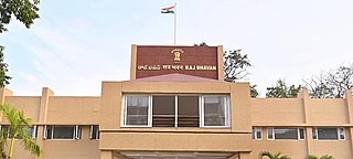
Suryaraopet is a locality in Vijayawada of the India state of Andhra Pradesh. It is the Health district of Vijayawada.The area consist of Many super Speciality hospitals. Andhra Pradesh Raj Bhavan also located in this area.

Tadipatri or Tadpatri is a city in Anantapur district of the Indian state of Andhra Pradesh at the border of Kurnool district and Kadapa district. It is the mandal headquarters of Tadipatri mandal in Anantapur revenue division. The Chintala Venkataramana Temple is located on a five-acre site in Tadipatri. The Bugga Ramalingeswara Temple is located one kilometer from the town, overlooking the Penna River.
Uravakonda is a census town in Anantapur district of the Indian state of Andhra Pradesh. It is the headquarters of Uravakonda mandal in Anantapur revenue division. The town is a constituent of urban agglomeration.
Vetapalem is a census town in Bapatla district of the Indian state of Andhra Pradesh. It is the mandal headquarters of Vetapalem mandal in Ongole revenue division.
Vaddeswaram is a census town in Guntur district of the Indian state of Andhra Pradesh. It is located at a distance of 5 km (3.1 mi) from Krishna River, in Tadepalle mandal part of Mangalagiri Tadepalle Municipal Corporation part of Guntur revenue division.
