The Willamette River is a major tributary of the Columbia River, accounting for 12 to 15 percent of the Columbia's flow. The Willamette's main stem is 187 miles (301 km) long, lying entirely in northwestern Oregon in the United States. Flowing northward between the Oregon Coast Range and the Cascade Range, the river and its tributaries form the Willamette Valley, a basin that contains two-thirds of Oregon's population, including the state capital, Salem, and the state's largest city, Portland, which surrounds the Willamette's mouth at the Columbia.

Crater Lake is a crater lake in south-central Oregon in the western United States. It is the main feature of Crater Lake National Park and is famous for its deep blue color and water clarity. The lake partly fills a nearly 2,148-foot (655 m)-deep caldera that was formed around 7,700 years ago by the collapse of the volcano Mount Mazama. There are no rivers flowing into or out of the lake; the evaporation is compensated for by rain and snowfall at a rate such that the total amount of water is replaced every 250 years. With a depth of 1,949 feet (594 m), the lake is the deepest in the United States. In the world, it ranks ninth for maximum depth, and third for mean (average) depth.

Multnomah Falls is a waterfall located in the Columbia River Gorge, east of Troutdale, between Corbett and Dodson, Oregon, United States. The waterfall is accessible from the Historic Columbia River Highway and Interstate 84. Spanning two tiers on basalt cliffs, it is the tallest waterfall in the state of Oregon at 620 ft (189 m) in height.

The Willamette Falls is a natural waterfall on the Willamette River between Oregon City and West Linn, Oregon, in the United States. It is the largest waterfall in the Northwestern United States by volume, and the seventeenth widest in the world. Horseshoe in shape, it is 1,500 feet (460 m) wide and 40 feet (12 m) high with a flow of 30,849 cu ft/s, located 26 miles (42 km) upriver from the Willamette's mouth.

Lolo Pass is a mountain pass 6 miles (10 km) northwest of Mount Hood and 10 miles (16 km) northeast of Zigzag, Oregon, on the Clackamas–Hood River county line. It divides the Sandy River watershed on the southwest from the Hood River watershed on the northeast.

Celilo Falls was a tribal fishing area on the Columbia River, just east of the Cascade Mountains, on what is today the border between the U.S. states of Oregon and Washington. The name refers to a series of cascades and waterfalls on the river, as well as to the native settlements and trading villages that existed there in various configurations for 15,000 years. Celilo was the oldest continuously inhabited community on the North American continent until 1957, when the falls and nearby settlements were submerged by the construction of The Dalles Dam.

Prospect State Scenic Viewpoint, is a state park south of the community of Prospect on Oregon Route 62 in Jackson County, in the U.S. state of Oregon. It was formerly known as Mill Creek Falls Scenic Area, a private hiking area that was developed by Willamette Industries along the Rogue River. Both Mill Creek Falls and Pearsony Falls are contained within the area, with Barr Creek Falls close by.

Algoma is an unincorporated community on the east shore of Upper Klamath Lake, in Klamath County, Oregon, United States. It is about 8 miles (13 km) north of the city of Klamath Falls on U.S. Route 97. Algoma was named for the Algoma Lumber Company.

Sam Barlow High School is a public high school in Gresham, Oregon, United States, in the Gresham-Barlow School District. It was named after the Oregon pioneer Sam Barlow.

White River Falls State Park is a state park in north central Oregon. It is located 35 miles (56 km) by road south of The Dalles and 4.5 miles (7.2 km) east of Tygh Valley.
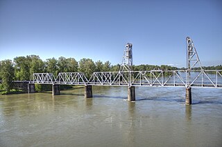
The Union Street Railroad Bridge is a vertical lift, Pratt through truss bridge that spans the Willamette River in Salem, Oregon, United States, built in 1912–13. It was last used by trains in the early 1990s and was sold for one dollar in 2003 to the City of Salem, which converted it to bicycle and pedestrian use in 2008–2009. It was added to the National Register of Historic Places in 2006.

Jackson F. Kimball State Recreation Site is a state park in southern Oregon. The park is operated and maintained by the Oregon Parks and Recreation Department, and is located approximately 20 miles (32 km) southeast of Crater Lake National Park and 3 miles (4.8 km) north of Fort Klamath. The park was established in 1955, and covers 19 acres (7.7 ha) including the headwaters of the Wood River.
Fairview Creek is a 5-mile (8.0 km) tributary of the Columbia Slough in the U.S. state of Oregon. The creek forms in a wetland near Grant Butte in Gresham and flows north for 5 miles (8.0 km) to Fairview Lake in Fairview. Grant Butte, rising to 602 feet (183 m) above sea level, is one of eight dormant volcanic formations near Gresham. Fairview Creek begins northeast of the butte at an elevation of 278 feet (85 m) and falls to an elevation of 10 feet (3.0 m) at the lake.

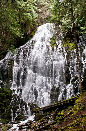
Salt Creek Falls is a cascade and plunge waterfall on Salt Creek, a tributary of the Middle Fork Willamette River, that plunges into a gaping canyon near Willamette Pass in the Willamette National Forest, near Oakridge, Oregon. The waterfall is notable for its main drop of 286 feet (87 m) which makes it the third highest plunge waterfall in Oregon after Multnomah Falls and Watson Falls the second highest, which was re-measured in 2009 and found to be 293 feet rather than an earlier measurement of 272 feet passing Salt Creek Falls. The pool at the bottom of the waterfall is 20 metres (66 ft) deep.
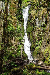
Ki-a-Kuts Falls is a 40-foot (12 m) tall waterfall on the Tualatin River in Washington County, Oregon, United States. Discovered in 1993 in the more remote upper stretch of the river, the falls were named after the last chief of the local band of Native Americans, Chief Ki-a-Kuts of the Atfalati. The water descends in a single fall down a narrow channel in the basalt cliffs overhanging the river at that spot.

Ramona Falls is an indie rock project founded by Brent Knopf and based in Portland, Oregon. The band name is taken from a waterfall located near Mt. Hood, a place where Knopf used to hike as a child. Brent Knopf co-founded Menomena before departing in 2011, and is also one-half of EL VY, a collaboration with The National's Matt Berninger.

The river sternwheeler Ramona operated from 1892 to 1908 on the Willamette River in Oregon, on the Stikine River running from Wrangell, Alaska into British Columbia, and the Fraser River, in British Columbia. This vessel should not be confused with the coastal steamship Ramona which also ran in Alaskan waters.
Upper Chush Falls is a 200-foot (61 m) waterfall on Whychus Creek, in the Cascade Range southwest of Sisters in the U.S. state of Oregon. Chush Falls, a 50-foot (15 m) waterfall, is further downstream on the same creek. Lying between Chush and Upper Chush is a third waterfall, The Cascade. These and several other falls on tributaries in the vicinity are within the Three Sisters Wilderness. The Northwest Waterfall Survey lists the fall's average flow at 40 cubic feet per second (1.1 m3/s). The highest flows occur between May and August.
Pringle Falls is a series of rapids or drops on the upper Deschutes River in the U.S. state of Oregon. From just downstream of Wyeth Campground, the rapids begin with about 600 feet (180 m) of whitewater rated class II (novice) on the International Scale of River Difficulty. The next 300 feet (91 m) is class III (intermediate] ending in a class IV drop. Soggy Sneakers: A Paddler's Guide to Oregon's Rivers says, "Only expert kayakers should consider this drop, and only after scouting. It is definitely not a rapids for open canoes."