Khaira is a village in Ludhiana district in the Indian state of Punjab.

Sonipat district is one of the 22 districts of Haryana state in North India. Sonipat town is the district headquarters. It is a part of National Capital Region. It is bordered by Delhi, Panipat, Rohtak, Jind, Jhajjar and Baghpat.

Morena district is one of the 53 districts of the central Indian state of Madhya Pradesh, located in the Chambal division.
Babua Kalan is a census town in Baghmara CD Block in Dhanbad Sadar subdivision of Dhanbad district in the state of Jharkhand, India.

Jaura is a town and a nagar palika in Morena district in the Indian state of Madhya Pradesh.
Sabalgarh is a municipality in Morena district in the Indian state of Madhya Pradesh.
Raghopur is a community development block in Vaishali district of Bihar. Situated between two streams of the Ganges river, it is a river island. It is connected to Patna by Pipa pul. Ancient name of Raghopur is Kotigram.

Gwalior Junction railway station is a main railway station of Gwalior City in the northern part of in the Indian state of Madhya Pradesh. Gwalior Junction is part of the Jhansi Division and falls under the administrative control of North Central Railway Zone of Indian Railways.
Jagpalpur is a village in Tehsil Phagwara, Kapurthala district, in Punjab, India.
Dumari Kalan is a village in the Sitamarhi district of Bihar state, India. Dumri Kalan Urf Madhuban Jadu village is located in Majorganj Tehsil of Sitamarhi district in Bihar, India. It is situated 5 km away from sub-district headquarter Majorganj and 30 km away from district headquarter Sitamarhi. As per 2009 stats, Dumari Kala is the gram panchayat of Dumri Kalan Urf Madhuban Jadu village. The total geographical area of village is 1107 hectares. Sitamarhi is nearest town to Dumri Kalan Urf Madhuban Jadu which is approximately 36 km away. According to the 2011 census it has a population of 10667 living in 2651 households.

Sabalgarh Assembly constituency is one of the 230 Vidhan Sabha constituencies of Madhya Pradesh state in central India. This constituency came into existence in 1951, as one of the 79 Vidhan Sabha constituencies of the erstwhile Madhya Bharat state. Sabalgarh is one of the six Vidhan Sabha constituencies located in Morena district. This constituency covers the entire Sabalgarh tehsil and part of Kailaras tehsil.
Mundawar is a Tehsil in Khairthal - Tijara district in Rajasthan State. Mundawar is 40 km from Alwar city.

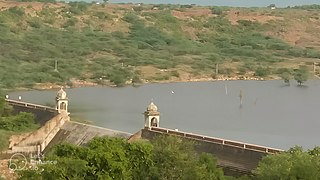
Sabalgarh Fort is a 16-17th-century hill fort near Sabalgarh, Madhya Pradesh, India. This fort is situated on a large rock in the northeastern part of Sabalgarh, The town was founded by Raja Sabal Singh. Presently, the fortress is in ruins and is infamous for stories of haunting and ghosts. The fort consists of a defensive structure and one main palaces and many other buildings. The fort has been controlled by a number of different rulers in its history.
Kailadevi is a village in Karauli Tehsil, in the Karauli District of the Indian state of Rajasthan. It falls under the Bharatpur Division. It is 26 km south of the district center Karauli, and 146 km from the state capital, Jaipur.
Milak is one of the 403 constituencies of the Uttar Pradesh Legislative Assembly, India. It is a part of the Rampur district and one of the five assembly constituencies in the Rampur Lok Sabha constituency. First election in this assembly constituency was held in 2012 after the "Delimitation of Parliamentary and Assembly Constituencies Order, 2008" was passed in the year 2008. The constituency is assigned identification number 38.

Sowaddi Kalan or Swaddi Khas is a village in Ludhiana district in the Indian state of Punjab. Kalan is Persian language word which means Big. It is one of the most educated villages in the area. Swaddi Kalan is a large village in Jagraon of Ludhiana district with a total of 954 families and 4,804 residents in 2011.
National Highway 552 is a National Highway in India. It is a spur road of National Highway 52. This highway traverses states of Rajasthan, Madhya Pradesh and Uttar Pradesh.
Jhander Kalan is a village in Shaheed Bhagat Singh Nagar district of Punjab State, India. Kalan is a Persian word for big and Khurd is a Persian word for small, when two villages have the same name they are distinguished by using Kalan or Khurd with the village name. It is located 9.2 kilometres (5.7 mi) away from postal head office Banga, 23 kilometres (14 mi) from Phagwara, 20 kilometres (12 mi) from district headquarter Shaheed Bhagat Singh Nagar and 113 kilometres (70 mi) from state capital Chandigarh. The village is administrated by Sarpanch an elected representative of the village.
Rampur is a village in Shaheed Bhagat Singh Nagar district of Punjab State, India. It is located 7.1 kilometres (4.4 mi) away from sub post office Ladhana Jhikka, 23 kilometres (14 mi) from Nawanshahr, 20 kilometres (12 mi) from district headquarter Shaheed Bhagat Singh Nagar and 113 kilometres (70 mi) from state capital Chandigarh. The village is administrated by Sarpanch an elected representative of the village.
