
Bhiwani district is one of the 22 districts of the northern Indian state of Haryana. Created on 22 December 1972, the district was the largest district of the state by area, before the creation of Charkhi Dadri as a separate district, as it occupied an area of 4,778 square kilometres (1,845 sq mi) and administered 442 villages with a population of 1,634,445. Sirsa is now the largest district of the state.

Belagavi district, formerly known as also Belgaum district, is a district in the state of Karnataka, India. The district is known as Sugar Bowl of Karnataka with 1.5 lakh (150,000) hectares being used for commercial production and it has displaced Mandya district in sugar cane production over the last decade. The city of Belgaum (Belagavi) is the district headquarters in Belagavi district. It houses the Second legislative building, where the Karnataka Legislature hold session once a year. The district is famous for its native sweet, Kunda. According to the 2011 Census of India, it has a population of 4,779,661, of which 24.03% live in urban areas, making it the second most populous district in Karnataka, after Bangalore Urban. The district has an area of 13,415 km2 (5,180 sq mi) making it the largest district in Karnataka, and is bounded by Kolhapur District and Sangli district of Maharashtra state on the west and north, on the northeast by Bijapur district, on the east by Bagalkot district, on the southeast by Gadag district, on the south by Dharwad and Uttara Kannada districts, and on the southwest by the state of Goa.


Gautam Buddha Nagardistrict is a district of Uttar Pradesh, named after Gautama Buddha. It is a part of Delhi NCR and is divided into 3 sub-divisions (Tehsils) i.e. Noida, Dadri and Jewar. Greater Noida is the administrative headquarters of Gautam Buddha Nagar district. Noida, Greater Noida, Dadri, Jewar and Dankaur fall under this district.

Etawah district is one of the districts in the western portion of Uttar Pradesh state of India. Etawah town is the district headquarters. The district covers an area of 2311 km2. It has a population of 1,581,810.

Morena district is one of the 52 districts of the central Indian state of Madhya Pradesh, located in the Chambal division.

Karnal district is one of the 22 districts of Haryana, a state in North India which constitutes the National Capital Region (NCR) of the country. The city of Karnal is a part of the National Capital Region (NCR) and is the administrative headquarters of the district.
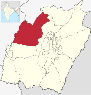
Tamenglong district is one of the 16 districts of Manipur state in northeastern India. In 2011, Tamenglong was the least populous distrct in Manipur. In 2016, the Noney subdivision was separated as a separate district.

Rupnagar is a city and a municipal council in Rupnagar district in the Indian state of Punjab. Rupnagar is a newly created fifth Divisional Headquarters of Punjab comprising Rupnagar, Mohali, and its adjoining districts. It is also one of the bigger sites belonging to the Indus Valley civilization. Rupnagar is nearly 43 km (27 mi) to the northwest of Chandigarh. It is bordered by Himachal Pradesh to the north and Shahid Bhagat Singh Nagar district to its west.
Ramsar County is in Mazandaran province, Iran. Its capital is the city of Ramsar.

Sangrur district is in the state of Punjab in northern India. Sangrur city is the district headquarters. It is one of the five districts in Patiala Division in the Indian state of Punjab. Neighbouring districts are Malerkotla (north), Barnala (west), Patiala (east), Mansa (southwest) and Fatehabad (Haryana) and Jind (Haryana) (south).

In India, a Community development block or simply Block is a sub-division of Tehsil, administratively earmarked for planning and development. In tribal areas, similar sub-divisions are called tribal development blocks. The area is administered by a Block Development Officer (BDO), supported by several technical specialists and village-level workers. A community development block covers several gram panchayats, the local administrative units at the village level.
Dodwad is a village in Belgaum district in the southern state of Karnataka, India.
Bassi is a sub-division of Jaipur district in the state of Rajasthan. It is approximately 30 km from Jaipur city which is now considered a part of the main city. The sub-district had a population of 229,639 spread over 210 villages.
Chehel Shahid Rural District is in Dalkhani District of Ramsar County, Mazandaran province, Iran. Its capital is the village of Chalakrud.
Jennat Rudbar Rural District is in Dalkhani District of Ramsar County, Mazandaran province, Iran.
Chalakrud is a village in, and the capital of, Chehel Shahid Rural District of Dalkhani District, Ramsar County, Mazandaran province, Iran.
Dalkhani, formerly Galesh Mahalleh, is a city in, and the capital of, Dalkhani District of Ramsar County, Mazandaran province, Iran.
Kalayeh Bon is a village in Chehel Shahid Rural District of Dalkhani District, Ramsar County, Mazandaran province, Iran.
Jennat Rudbar is a village in Jennat Rudbar Rural District of Dalkhani District, Ramsar County, Mazandaran province, Iran.