
Hot Spring County is located in the U.S. state of Arkansas. As of the 2010 census, the population was 32,923. The county seat is Malvern. Hot Spring County was formed on November 2, 1829, from a portion of Clark County. It was named for the hot springs at Hot Springs, Arkansas, which were within its boundaries until Garland County was formed in 1874. It is an alcohol prohibition or dry county. However, there is no record of this law.

Flores Island is a small island in Clayoquot Sound, off the west coast of Vancouver Island, British Columbia, Canada.
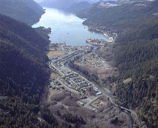
Tahsis is a village municipality on the west coast of Vancouver Island, British Columbia, Canada, about 300 km (186 mi) northwest of the provincial capital Victoria at 49°55′33″N126°37′16″W. As of 2011, the Canadian census listed 316 residents, a decline from the 2006 Census count of 366 residents. The Village of Tahsis economy used to be dependent on forestry, but after the closure of the local sawmill in 2001, the economy became heavily dependent on sport fishing for salmon and halibut, outdoor recreation and tourism.

Porteau Cove Provincial Park is a provincial park located along the eastern shore of Howe Sound in British Columbia, Canada.

Liard River Hot Springs Provincial Park is a provincial park in British Columbia, Canada. It is home to the largest natural hot springs in Canada. It is a natural river of hot water rather than a spring fed man made pool The park is part of the larger Muskwa-Kechika Management Area. The community of Liard River, British Columbia is located nearby.

Maquinna Marine Provincial Park and Protected Area is a provincial park in British Columbia, Canada, located northwest of Tofino in the Clayoquot Sound region of the West Coast of Vancouver Island, protecting Ramsay Hot Springs, which is the name-source of the cove, settlement and former post office of Hot Springs Cove.

Nuchatlitz Provincial Park is a provincial park in British Columbia, Canada, located no the northwest side of Nootka Island, facing Nuchatlitz Inlet, on the west coast of Vancouver Island. Established in 1996, the park contains approximately 2105 ha.

Smuggler Cove Marine Provincial Park is a provincial park in British Columbia, Canada.
The Magnet Cove igneous complex is a small alkalic ring complex lying to the west of the town of Magnet Cove in Hot Spring County, Arkansas. It and the adjacent town are so named due to the existence of magnetite and the terrain being a cove, a basin-shaped valley.

Gilford Island is an island in British Columbia, Canada, located between Tribune Channel and Knight Inlet. The island has an area of 384 square kilometres (148 sq mi). Turnour Island is to the south across Tribune Channel, the entrance to Thompson Sound to the east.

South Twin Lake having about 3,200 acres (13 km2) is wholly within Penobscot County, Maine. It is about 6 miles (10 km) west of Millinocket, Maine and is part of the Pemadumcook Chain of Lakes. The lake is centered at 45°37.25′N68°51′W and has spillway elevation 492 feet (150 m) above sea level. It is part of the watershed of the West Branch of the Penobscot River.

Hot Springs Cove, formerly Refuge Cove, is an unincorporated settlement on Sydney Inlet on the west side of the Openit Peninsula in the western Clayoquot Sound region of the West Coast of Vancouver Island. Hot Springs Cove derives its name from its proximity to Ramsay Hot Springs, and is protected by Maquinna Marine Provincial Park. The post office at Hot Springs Cove was closed in 1974 but had operated since 1947, when it was first named Sydney Inlet until being renamed in 1948. Despite the closure of the post office, there remains a year-round population in the vicinity.
Musket Island Marine Provincial Park is a provincial park in British Columbia, Canada, located on the west side of Nelson Island, at the mouth of Jervis Inlet and near Earl's Cove in the Sunshine Coast region.

The Terminal Range is the northernmost mountain range of the Canadian Rockies, so-named for its position at the northern terminus of the Rockies. Lying west of Muncho Lake and the Trout River, its northern perimeter is the Liard River. The Sentinel Range lies to its east.
Myrica or Myrika, also called Myrikion and Therma, was a city and bishopric in Galatia Salutaris, known for its hot springs.
Lagoon Cove, British Columbia, Canada, is located between East and West Cracroft Islands in the Inside Passage between Vancouver Island and the North American mainland. There is a commercial marina located there serving pleasure boaters. It can be approached from Knight Inlet at Minstrel Island, or from Clio Channel, or from Chatham Channel via The Blow Hole.
The New Westminster Land District is one of 59 land districts of British Columbia, Canada, which are the underlying cadastral divisions of that province, created with rest of those on Mainland British Columbia via the Lands Act of the Colony of British Columbia in 1860. The British Columbia government's BC Names system, a subdivision of GeoBC, defines a land district as "a territorial division with legally defined boundaries for administrative purposes" All land titles and surveys use the Land District system as the primary point of reference, and entries in BC Names for placenames and geographical objects are so listed.
Tallheo Hot Springs is a hot spring located on the west shore of South Bentinck Arm, an inlet on the Central Coast of British Columbia, Canada, located southwest of the community of Bella Coola. The hot springs, which are known as Ix7piixm in the Nuxalk language, are located opposite Bensins Island, the only island in South Bentinck Arm.
Bonwick Island is an island in the Broughton Archipelago in Central Coast region of British Columbia, Canada. The archipelago is located on the northeast side of Queen Charlotte Strait and lies northwest of the Village of Alert Bay and immediately to the west of Gilford Island, separated from it by Retreat Pass. Arrow Passage is on the island's northwest, separating it from Mars Island.
