Ramsden Dock

Last updated

Three BNFL vessels registered at the Port of Barrow berthed in Ramsden Dock in 2006 We three ships. - geograph.org.uk - 138109.jpg
Three BNFL vessels registered at the Port of Barrow berthed in Ramsden Dock in 2006

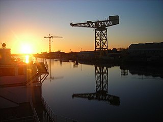
Ramsden Dock is one of the four docks which make up the Port of Barrow in Barrow-in-Furness, England. It was constructed between 1872 and 1879 covering 162,000 square metres (1,740,000 sq ft) and named in honour of Sir James Ramsden; a founder of Barrow. [1] Ramsden Dock splits into two parts in the south, the anchor basin and dock basin. Since the infilling of a section of Devonshire Dock in the 1980s, Ramsden Dock has been the only point of entry to Barrow's now enclosed port. [1] Managed by Associated British Ports, Ramsden Dock is by far the busiest of the four dock in terms of cargo tonnage, handling shipments of limestone, sand, aggregates and granite. [2] Ramsden Dock and the Port of Barrow as a whole are highly involved in the energy sector and the nearby Rampside Gas Terminal, Sellafield nuclear facility and offshore windfarms. [2] The port office is located adjacent to Ramsden Dock. [2] Powerboat racing often takes place in Ramsden Dock, while a proposed redevelopment scheme of the area incorporates a watersports centre within the dock. [3]

Port of Barrow dock

The Port of Barrow refers to the enclosed dock system within the town of Barrow-in-Furness, England. Morecambe Bay is to the east of the port and the Irish Sea surrounds it to the south and west. The port is currently owned and operated by Associated British Ports Holdings, but some land is shared with BAE Systems Submarine Solutions. Currently consisting of four large docks, the Port of Barrow is one of North West England's most important ports. The docks are as follows: Buccleuch Dock, Cavendish Dock, Devonshire Dock and Ramsden Dock. The port of Barrow is the only deep water port between the Mersey and the Clyde.

Barrow-in-Furness town and seaport in the county of Cumbria, England

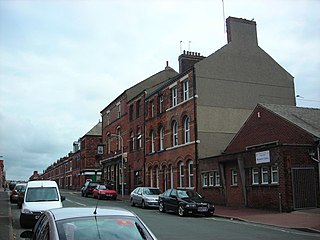
Barrow-in-Furness, commonly known as Barrow, is a town and borough in Cumbria, England. Historically part of Lancashire, it was incorporated as a municipal borough in 1867 and merged with Dalton-in-Furness Urban District in 1974 to form the Borough of Barrow-in-Furness. At the tip of the Furness peninsula, close to the Lake District, it is bordered by Morecambe Bay, the Duddon Estuary and the Irish Sea. In 2011, Barrow's population was 57,000, making it the second largest urban area in Cumbria after Carlisle, although it is geographically closer to the whole of Lancashire and most of Merseyside. Natives of Barrow, as well as the local dialect, are known as Barrovian.

Devonshire Dock

Devonshire Dock is the oldest of the four docks which make up the Port of Barrow in Barrow-in-Furness, England. Although the dock falls under the control of Associated British Ports it is currently solely utilised by BAE Systems. Upon completion of the dock, Prime Minister William Ewart Gladstone stated 'Barrow would one day become another Liverpool'. Although it's shipbuilding capabilities have exceeded those on Merseyside, the port and dock system itself never fully met James Ramsden's grand vision for the town.

Historically, Ramsden Dock was a major transportation hub with a dedicated railway station connected to a branch of the Furness Railway and a terminus of the Barrow-in-Furness Tramway. A passenger ferry terminal at the dock was utilised by the Isle of Man Steam Packet and Barrow Steam Navigation Company offering steamer services to the likes of Belfast and Douglas, Isle of Man. [4] A rail line along the eastern perimeter of Ramsden Dock remains in use to this day with freight services to and from the dock.

Ramsden Dock railway station was the terminus of the Furness Railway's Ramsden Dock Branch in Barrow-in-Furness, England.

Furness Railway transport company

The Furness Railway (Furness) was a railway company operating in the Furness area of Lancashire in North West England.

The Barrow-in-Furness Tramways Company operated a tramway service in Barrow-in-Furness between 1885 and 1932.

Related Research Articles

Barrow Island, Barrow-in-Furness

Barrow Island is an area and electoral ward of Barrow-in-Furness, Cumbria, England. Originally separate from the British mainland, land reclamation in the 1860s saw the northern fringes of the island connect to Central Barrow. Barrow Island is also bound to the south and east by the town's dock system and to the west by Walney Channel. The Ward population taken at the 2011 census was 2,616.

Furness and Midland Joint Railway transport company

The Furness and Midland Joint Railway was a joint railway in England owned by the Furness Railway and the Midland Railway. Construction was agreed in 1862 for a line from Carnforth, on the Furness system, to Wennington, on the Midland Railway line from Yorkshire to Morecambe - royal assent was received in June 1863 and the contract for the route was let to messrs Benton & Woodiwiss soon after at a cost of some £102,850.

Port of Hull

The Port of Hull is a port at the confluence of the River Hull and the Humber Estuary in Kingston upon Hull, East Riding of Yorkshire, England.

Cardiff Docks

Cardiff Docks is a port in southern Cardiff, Wales. At its peak, the port was one of the largest dock systems in the world with a total quayage of almost 7 mi (11 km). Once the main port for the export of South Wales coal, the Port of Cardiff remains active in the import and export of containers, steel, forest products and dry and liquid bulks.

Hindpool human settlement in United Kingdom

Hindpool is an area and electoral ward of Barrow-in-Furness, Cumbria, England. It is bordered by Barrow Island, Central Barrow, Ormsgill, Parkside and the Walney Channel, the local population stood at 5,851 in 2011. The ward covers the entire western half of the town centre and includes Barrow's main shopping district. Other local landmarks include the Furness College Channelside campus, the Dock Museum and the Main Public Library. Hindpool is also home to two stadia - Barrow Raiders' Craven Park and Barrow A.F.C.'s Holker Street.

Irish Sea Sea which separates the islands of Ireland and Great Britain

The Irish Sea separates the islands of Ireland and Great Britain; linked to the Celtic Sea in the south by St George's Channel, and to the Inner Seas off the West Coast of Scotland in the north by the Straits of Moyle.

Buccleuch Dock

Buccleuch Dock is one of the four docks which make up the Port of Barrow in Barrow-in-Furness, England. It was constructed between 1863 and 1872 to the same specification as the attached Devonshire Dock - the docks having been separated by a bridge for most of their lifetime. Buccleuch Dock covers 125,000 square metres (1,350,000 sq ft) and was named after Walter Montagu Douglas Scott, 5th Duke of Buccleuch, whom invested heavily in Barrow's public services during the late-19th century. Buccleuch Dock is owned by Associated British Ports and is also used by BAE Systems where the majority of the shipyard's surface vessels are docked for fitting out.

Cavendish Dock

Cavendish Dock is one of the four docks which make up the Port of Barrow in Barrow-in-Furness, England. Covering some 591,000 square metres (6,360,000 sq ft) it is roughly the size of Barrow's other three docks combined. It is named after William Cavendish, 7th Duke of Devonshire whom invested heavily in the industrial growth of Barrow. Cavendish Dock is owned by Associated British Ports, however it is now entirely enclosed serving as a reservoir. It is also a popular fishing destination due to the diverse and unique wildlife found as a result of the control of water in and out the dock.

The Waterfront Barrow-in-Furness

The Waterfront Barrow-in-Furness is a £200 million development under construction in and around the Port of Barrow, England. The site covers an area of some 400 acres (160 ha) and was due for completion in 2020. The internal road network is already complete, with construction of a large business park complex ongoing and work on a 400-berth marina and 650 home Marina Village due to start thereafter. In 2010, The Waterfront Barrow-in-Furness ranked as the ninetieth most costly regeneration project in the United Kingdom by Regeneration & Renewal. Progress on the project stalled between 2010 and 2016 due to complications with funding following the disabandonment of the North West Regional Development Agency. BAE Systems opened a large logistics warehouse named the Resolution Building on Dova Way within the designated Business Park Area in October 2016, while and construction of a new access road from Salthouse Road to the Marina Village commenced in May 2017.

Barrow-in-Furness Main Public Library public library in Barrow-in-Furness, Cumbria

Barrow-in-Furness Main Public Library is a Grade II listed Beaux-Arts style building located at Ramsden Square, Barrow-in-Furness, England. Operated since 1974 by Cumbria County Council, it is the largest library in the town and the present structure, designed by J A Charles was originally built as a Carnegie library with support from the Carnegie Foundation.

SS <i>Monas Queen</i> (1885)

SS (RMS) Mona's Queen (II) No. 76308, was an iron-built paddle steamer which served with the Isle of Man Steam Packet Company. She was the second vessel in the Company's history to be so named. Mona's Queen served from 1885 until 1929. In 1917, during the Great War, she collided with a German submarine.

Abbots Wood, Cumbria grade II listed building in the United kingdom

Abbot's Wood was a large country house and estate located to the north-northeast of Barrow-in-Furness, Cumbria, England. It was sited on elevated ground to the northeast of Furness Abbey. The house was surrounded by extensive grounds with footpaths providing fine views.

Island Road railway station

Island Road railway station was a railway station at the centre of Barrow Island, Barrow-in-Furness, England which operated between 1899 and 1967. It was built by the Furness Railway near the junction of the Ramsden Branch Line and a line which ran through the industrial areas of the town.

Piel railway station

Piel railway station was the terminus of the Furness Railway's Piel Branch in Barrow-in-Furness, England that operated between 1846 and 1936. Located on Roa Island it was built to serve the passenger steamers at Piel Pier. The Roa Island causeway was specifically constructed for the railway, in turn making the island part of the British mainland. The station and the Piel Branch line have both been demolished, however the Roa Island Hotel which was built adjoining the station survives to this day as a Grade II listed building.

References

  1. 1 2 "Ramsden Dock, Barrow". Engineering Timelines. Retrieved 12 January 2015.
  2. 1 2 3 "ABP Barrow". Associated British Ports. Retrieved 12 January 2015.
  3. "The Water Sports Centre". Furness Enterprise. Retrieved 12 January 2015.
  4. "Go Anywhere On a Boat From Barrow". North West Evening Mail. Archived from the original on 12 January 2015. Retrieved 12 January 2015.


Coordinates: 54°06′08″N3°12′51″W / 54.1021°N 3.2142°W / 54.1021; -3.2142

Geographic coordinate system Coordinate system

A geographic coordinate system is a coordinate system that enables every location on Earth to be specified by a set of numbers, letters or symbols. The coordinates are often chosen such that one of the numbers represents a vertical position and two or three of the numbers represent a horizontal position; alternatively, a geographic position may be expressed in a combined three-dimensional Cartesian vector. A common choice of coordinates is latitude, longitude and elevation. To specify a location on a plane requires a map projection.