Related Research Articles

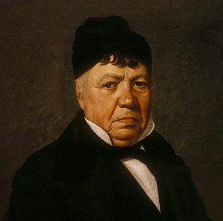
Don Pío de Jesús Pico IV was a Californio politician, ranchero, and entrepreneur, famous for serving as the last governor of Alta California under Mexican rule from 1845 to 1846. He briefly held the governorship during a disputed period in 1832. A member of the prominent Pico family of California, he was one of the wealthiest men in California at the time and a hugely influential figure in Californian society, continuing as a citizen of the nascent U.S. state of California.

Californios are Hispanic Californians, especially those descended from Spanish and Mexican settlers of the 17th through 19th centuries before California was annexed by the United States. California's Spanish-speaking community has resided there since 1683 and is made up of varying Spanish and Mexican origins, including criollos, Mestizos, Indigenous Californian peoples, and small numbers of Mulatos. Alongside the Tejanos of Texas and Neomexicanos of New Mexico and Colorado, Californios are part of the larger Spanish-American/Mexican-American/Hispano community of the United States, which has inhabited the American Southwest and the West Coast since the 16th century. Some may also identify as Chicanos, a term that came about in the 1960s.
José Antonio de la Guerra y Noriega was a Californio military officer, ranchero, and founder of the prominent Guerra family of California. He served as the Commandant of the Presidio of Santa Barbara and the Presidio of San Diego.

Rancho Santa Margarita y Las Flores was a 133,440-acre (540.0 km2) Mexican land grant in present-day northwestern San Diego County, California given by governor Juan Alvarado in 1841 to Andrés Pico and Pio Pico. The grant was located along the Pacific coast, and encompassed present-day San Onofre State Beach and Camp Pendleton. The site is now registered as California Historical Landmark #1026.
The history of Santa Barbara, California, begins approximately 13,000 years ago with the arrival of the first Native Americans. The Spanish came in the 18th century to occupy and Christianize the area, which became part of Mexico following the Mexican War of Independence. In 1848, the expanding United States acquired the town along with the rest of California as a result of defeating Mexico in the Mexican–American War. Santa Barbara transformed then from a small cluster of adobes into successively a rowdy, lawless Gold Rush era town; a Victorian-era health resort; a center of silent film production; an oil boom town; a town supporting a military base and hospital during World War II; and finally it became the economically diverse resort destination it remains in the present day. Twice destroyed by earthquakes, in 1812 and 1925, it was rebuilt after the second one in a Spanish Colonial style.
The Ávila family was a prominent Californio family of Spanish origins from Southern California, founded by Cornelio Ávila in the 1780s. Numerous members of the family held important rancho grants and political positions, including two Alcaldes of Los Angeles.
Rancho La Sierra was a 17,774-acre (71.93 km2) Mexican land grant in present-day Riverside County, California, United States. In 1846 Governor Pio Pico issued the grant to Vicenta Sepulveda. The rancho includes the present-day city of Norco, and the western end of Riverside.
Rancho Los Álamos y Agua Caliente was a 26,626-acre (107.75 km2) Mexican land grant in present-day Kern County, California given in 1846 by Governor Pio Pico to Francisco Lopes, Luis Jordan and Vicente Botiller. The name means "Cottonwoods and Hot Springs Ranch" in Spanish. The native riparian Fremont Cottonwood (Populus fremontii) grow around natural springs. Rancho Los Álamos y Agua Caliente lay between two other Mexican Land Grants in the Tehachapi Mountains, Rancho El Tejon and Rancho Castac. The rancho is now a part of the 270,000 acres (1,093 km2) Tejon Ranch.
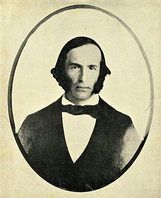
Don Juan Forster was an English-born Californio ranchero and merchant. Born in England, he emigrated to Mexico at age 16 and became a Mexican citizen. Soon after, he moved to California, where he married into the prominent Pico family of California and eventually held vast rancho grants across Southern California.
Rancho La Laguna was a 48,704-acre (197.10 km2) Mexican land grant in present-day Santa Barbara County, California given in 1845 by Governor Pio Pico to Octaviano Gutierrez. The name means "the Lake". The grant extended along the Santa Ynez Valley east of present-day Los Alamos.
Rancho Mission Vieja de la Purísima was a 4,414-acre (17.86 km2) Mexican land grant in present-day northern Santa Barbara County, California given in 1845 by Governor Pío Pico to Joaquín Carrillo and José Antonio Carrillo. The grant included the original site of Mission La Purísima Concepción, located north of present-day Lompoc.
Rancho San Carlos de Jonata was a 26,634-acre (107.78 km2) Mexican land grant in present-day Santa Barbara County, California given in 1845 by Governor Pío Pico to Joaquín Carrillo and Jose Maria Covarrubias. The grant was west of Mission Santa Inés in the Santa Ynez Valley, and extended north from the Santa Ynez River along Zaca Creek. The grant encompasses present-day Solvang and Buellton.
Rancho La Goleta was a 4,426-acre (17.91 km2) Mexican land grant in present-day Santa Barbara County, California given in 1846 by Governor Pío Pico to Daniel A. Hill. The grant extended along the Pacific coast from today’s Fairview Avenue in present-day Goleta, east to Hope Ranch. The grant was adjacent to Rancho Dos Pueblos granted to his son-in-law Nicolas A. Den in 1842.
Rancho de la Nación was a 26,632-acre (107.78 km2) Mexican land grant in present-day southern San Diego County, California given in 1845 by Governor Pío Pico to John Forster. The grant encompassed present-day National City, Chula Vista, Bonita, Sunnyside and the western Sweetwater Valley.
Rancho Las Posas was a 26,623-acre (107.74 km2) Mexican land grant in present-day Ventura County, California. It was given in 1834 by Governor José Figueroa to José Antonio Carrillo.
Rancho Las Baulines was a 8,911-acre (36.06 km2) Mexican land grant in present-day Marin County, California, given in 1846 by Governor Pío Pico to Gregorio Briones. The grant extended around Bolinas Lagoon and encompassed present-day Stinson Beach and Bolinas.
El Camino Viejo a Los Ángeles, also known as El Camino Viejo and the Old Los Angeles Trail, was the oldest north-south trail in the interior of Spanish colonial Las Californias (1769–1822) and Mexican Alta California (1822–1848), present day California. It became a well established inland route, and an alternative to the coastal El Camino Real trail used since the 1770s in the period.

The Mexican Secularization Act of 1833, officially called the Decree for the Secularization of the Missions of California, was an act passed by the Congress of the Union of the First Mexican Republic which secularized the Californian missions. The act nationalized the missions, transferring their ownership from the Franciscan Order of the Catholic Church to the Mexican authorities.

The Carrillo family is a prominent Californio family of Southern California. Members of the family held extensive rancho grants and numerous important political positions, including Governor of Alta California, Mayor of Los Angeles, Mayor of Santa Barbara, Mayor of Santa Monica, and a signer of the Californian Constitution.

The Pico family is a prominent Californio family of Southern California. Members of the family held extensive rancho grants and numerous important positions, including Governor of Alta California, signer of the Constitution of California, and California State Senator, among numerous others. Numerous locations are named after the family across California.
References
- ↑ Ogden Hoffman, 1862, Reports of Land Cases Determined in the United States District Court for the Northern District of California, Numa Hubert, San Francisco
- ↑ Diseño del Rancho Las Positas y La Calera
- ↑ Santa Barbara County Rancho Map
- ↑ Ancestors of Sylvia Noreen Robbins
- ↑ United States. District Court (California : Southern District) Land Case 184 SD
- ↑ Finding Aid to the Documents Pertaining to the Adjudication of Private Land Claims in California, circa 1852-1892
- ↑ Report of the Surveyor General 1844 - 1886 Archived 2013-03-20 at the Wayback Machine
- ↑ Kevin Starr, 1991, Material Dreams: Southern California Through the 1920s, Oxford University Press, ISBN 978-0-19-507260-0
- ↑ Walter A. Tompkins, 1980, Old Spanish Santa Barbara:From Cabrillo to Fremont, McNally & Loftin, ISBN 978-0-87461-030-7