
Maida Vale is a London Underground station in Maida Vale in inner north-west London. The station is on the Bakerloo line, between Kilburn Park and Warwick Avenue stations, and is in Travelcard Zone 2.
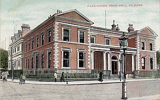
Paddington was a civil parish and metropolitan borough in London, England. It was an ancient parish in the county of Middlesex, governed by an administrative vestry. The parish was included in the area of responsibility of the Metropolitan Board of Works in 1855 and became part of the County of London in 1889. The parish of Paddington became a metropolitan borough in 1900, following the London Government Act 1899, with the parish vestry replaced by a borough council. In 1965 the borough was abolished and its former area became part of the City of Westminster in Greater London.

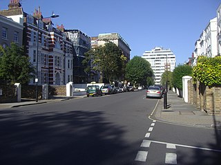
Maida Vale is an affluent residential district in West London, England, north of Paddington, south-west of St John's Wood and south of Kilburn, on the Edgware Road. It is part of the City of Westminster and is 3.1 miles (5.0 km) north-west of Charing Cross. It has many late Victorian and Edwardian blocks of mansion flats. The area is home to the BBC Maida Vale Studios.
Kingsthorpe is a suburb and civil parish of Northampton, England. It is situated to the north of Northampton town centre and is served by the A508 and A5199 roads which join at Kingsthorpe's centre. The 2011 Census recorded the population of the district council ward as 4,477.

The Harrow Road is an ancient route in North West London which runs from Paddington in a northwesterly direction towards Harrow. It is also the name given to the immediate surrounding area of Queens Park and Kensal Green, straddling the NW10, W10, W2 and W9 postcodes. With minor deviations in the 19th and 20th centuries, the route remains otherwise unaltered.

Addison Avenue is a street in the Notting Hill area of London. Located in the Royal Borough of Kensington and Chelsea, it runs northwards from Holland Park Avenue to St James's Gardens and St James' Church, crossing Queensdale Road about halfway along. Norland Square is located to its east while Royal Crescent is a little way to the west. A broad, tree-lined avenue, it is largely residential with some commercial properties at the southern end. The smaller Addison Place mews street runs off the western side of the road, looping northwards until it meets Queensdale Road. Addison Avenue is in the wealthy London area of Holland Park.
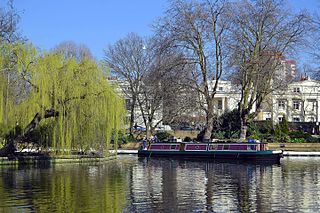
Little Venice is an affluent residential district in West London, England, around the junction of the Paddington Arm of the Grand Union Canal, the Regent's Canal, and the entrance to Paddington Basin. The junction forms a triangular shape basin. Many of the buildings in the vicinity are Regency white painted stucco terraced town houses and taller blocks (mansions) in the same style. The area is 2.5 miles (4.0 km) west-north-west of Charing Cross and immediately north-west of Paddington.
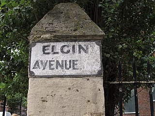
Elgin Avenue is a street in Maida Vale in London. Located in the City of Westminster, it runs east to west from the A5 road close to Maida Vale tube station west to the Maida Hill area where it meets the Harrow Road. Sutherland Avenue runs roughly parallel to the south and is connected to Elgin Avenue by Lauderdale Road. The road continues east of the A5 as Abercorn Place which runs through St. John's Wood.
Abercorn Place is a street in St John's Wood in London. Located in the City of Westminster, it runs west to east from the Edgware Road at Maida Vale until it joins Abbey Road not far from the Abbey Road Studios to the south. It is crossed by Hamilton Terrace. The street is named after the Duke of Abercorn, an Anglo-Irish aristocrat. It was part of an estate originally owned by Harrow School of which Abercorn was a governor with other nearby streets similarly named. The street contains a mixture of housing from the 1820s onwards. Several buildings in the street are listed today. The Anglican St Mark's Church was built in 1847 at the intersection with Hamilton Terrace. It was designed in the Gothic style by the architect Thomas Cundy.

Warrington Crescent is a street in Maida Vale in London. Located in the City of Westminster, it is a crescent curving north eastwards from Warwick Avenue until it reaches a roundabout where it meets including Randolph Avenue, Sutherland Avenue and Lauderdale Road. Warrington Gardens and Formosa Street both lead westwards off Warrington Crescent.
Sutherland Avenue is a street in Maida Vale in London, England. Located in the City of Westminster on the northern edge of Little Venice. it is an avenue running east to west from the Edgware Road to Harrow Road. Along the route it is crossed or joined by Randolph Avenue, Warrington Crescent, Lauderdale Road, Castellian Road, Warwick Avenue and Shirland Road. Elgin Avenue runs directly parallel to the north.

Lauderdale Road is a street in the Maida Vale district of London. Located in the City of Westminster, it runs north westwards from Sutherland Avenue to Elgin Avenue. Its southern end also meets Warrington Crescent and Randolph Avenue at a roundabout.

Maida Avenue is a road in the Little Venice area of Maida Vale in London. Located in the City of Westminster, it follows the southern bank of the Regent's Canal close to its junction with the Grand Union Canal. It runs between Warwick Avenue and Edgware Road. Directly across the canal Blomfield Road runs parallel to Maida Avenue.

Carlton Vale is a street that runs through Kilburn and Maida Vale in London. Some of its route forms the boundary between the City of Westminster to the south and the London Borough of Brent to the north. To the west the street continues as Kilburn Lane through Queen's Park, while to the east it becomes Carlton Hill running into St. John's Wood. Carlton Vale crosses or meets several roads including Kilburn Park Road, Cambridge Road and Randolph Avenue.

Gloucester Avenue is a street in the Primrose Hill area of London, England. Located in the London Borough of Camden, it is a residential road featuring many nineteenth century properties including several pubs as well as the neo-Georgian Cecil Sharp House. For much of its route it runs adjacent to the West Coast Main Line out of Euston Station.

Norfolk Square is a rectangular garden square in Paddington in Central London. Located in the City of Westminster, it is part of the Tyburnia district north of Hyde Park. It runs east to west from London Street to Norfolk Place. Praed Street and Sussex Gardens are directly parallel to it north and south respectively.

Oakley Square is a crescent-shaped garden square in Somers Town in Central London, close to Mornington Crescent and Camden Town. It is located in the London Borough of Camden and runs roughly northeastwards from Eversholt Street meeting with the southern end of Camden Street on its eastern side.

Norland Square is a garden square in the Notting Hill area of London. Located in the Royal Borough of Kensington and Chelsea, runs northward from Holland Park Avenue to Queensdale Road. The mews street Norland Place runs eastwards of the Square.

Connaught Street is a street in Central London. Located in the City of Westminster, it is part of the Tyburnia area of Paddington north of Hyde Park. It runs west to east from Hyde Park Square to the Edgware Road. It continues eastwards becoming Upper Berkeley Street in Marylebone. The street contains a mixture of commercial and residential properties, forming part of Connaught Village. Connaught Square and Albion Street are located on its southern side. The Duke of Kendal public house sits at the junction between Connaught Street and Kendal Street.

Flask Walk is a street in Hampstead in the London Borough of Camden. It runs eastwards from Hampstead High Street to a junction with Well Walk and New End Square. It is primarily residential but the western end of the street is a pedestrianised alley featuring commercial properties. Hampstead tube station is located close to the junction with the High Street.


