
Warwick Avenue is a London Underground station in Little Venice in the City of Westminster in northwest London. The station is on the Bakerloo line, between Paddington and Maida Vale stations, and is in Travelcard Zone 2.

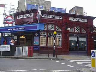
Maida Vale is an affluent residential district in West London, England, north of Paddington, south-west of St John's Wood and south of Kilburn, on the Edgware Road. It is part of the City of Westminster and is 3.1 miles (5.0 km) north-west of Charing Cross. It has many late Victorian and Edwardian blocks of mansion flats. The area is home to the BBC Maida Vale Studios.

Dr Johnson's House is a writer's house museum in London in the former home of the 18th-century English writer and lexicographer Samuel Johnson. The house is a Grade I listed building.

Addison Avenue is a street in the Notting Hill area of London. Located in the Royal Borough of Kensington and Chelsea, it runs northwards from Holland Park Avenue to St James's Gardens and St James' Church, crossing Queensdale Road about halfway along. Norland Square is located to its east while Royal Crescent is a little way to the west. A broad, tree-lined avenue, it is largely residential with some commercial properties at the southern end. The smaller Addison Place mews street runs off the western side of the road, looping northwards until it meets Queensdale Road. Addison Avenue is in the wealthy London area of Holland Park.

Warwick Avenue is a residential avenue in the Little Venice area of Maida Vale, London. Its southern end is situated adjacent to Paddington Basin, to the north of Paddington station.
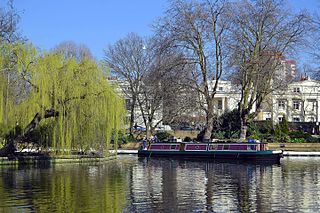
Little Venice is an affluent residential district in West London, England, around the junction of the Paddington Arm of the Grand Union Canal, the Regent's Canal, and the entrance to Paddington Basin. The junction forms a triangular shape basin. Many of the buildings in the vicinity are Regency white painted stucco terraced town houses and taller blocks (mansions) in the same style. The area is 2.5 miles (4.0 km) west-north-west of Charing Cross and immediately north-west of Paddington.

Mount Vernon House is a house in Hampstead in the London Borough of Camden. It has been listed Grade II on the National Heritage List for England (NHLE) since May 1974. The garden wall is separately listed at Grade II. The house was built around 1726 and was altered in the early 19th century. It is rendered in stucco with a mansard roof. The house occupies the site of a windmill. It was constructed between 1725 and 1728 by a local Hampstead timbersmith, William Knight.
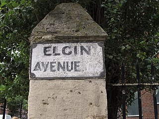
Elgin Avenue is a street in Maida Vale in London. Located in the City of Westminster, it runs east to west from the A5 road close to Maida Vale tube station west to the Maida Hill area where it meets the Harrow Road. Sutherland Avenue runs roughly parallel to the south and is connected to Elgin Avenue by Lauderdale Road. The road continues east of the A5 as Abercorn Place which runs through St. John's Wood.
Abercorn Place is a street in St John's Wood in London. Located in the City of Westminster, it runs west to east from the Edgware Road at Maida Vale until it joins Abbey Road not far from the Abbey Road Studios to the south. It is crossed by Hamilton Terrace. The street is named after the Duke of Abercorn, an Anglo-Irish aristocrat. It was part of an estate originally owned by Harrow School of which Abercorn was a governor with other nearby streets similarly named. The street contains a mixture of housing from the 1820s onwards. Several buildings in the street are listed today. The Anglican St Mark's Church was built in 1847 at the intersection with Hamilton Terrace. It was designed in the Gothic style by the architect Thomas Cundy.
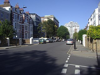
Randolph Avenue is a street in Maida Vale in London. Located in the City of Westminster, it is a long avenue running from north to south. The southern end is located in Little Venice near to the Paddington branch of the Grand Union Canal. The street runs northwards, crossing Clifton Gardens, Sutherland Avenue, Elgin Avenue and Carlton Vale. The road then continues as Randolph Gardens until it meets Kilburn Park Road. The Edgware Road runs directly parallel to Randolph Avenue to the east.
Sutherland Avenue is a street in Maida Vale in London, England. Located in the City of Westminster on the northern edge of Little Venice. it is an avenue running east to west from the Edgware Road to Harrow Road. Along the route it is crossed or joined by Randolph Avenue, Warrington Crescent, Lauderdale Road, Castellian Road, Warwick Avenue and Shirland Road. Elgin Avenue runs directly parallel to the north.

Lauderdale Road is a street in the Maida Vale district of London. Located in the City of Westminster, it runs north westwards from Sutherland Avenue to Elgin Avenue. Its southern end also meets Warrington Crescent and Randolph Avenue at a roundabout.

Maida Avenue is a road in the Little Venice area of Maida Vale in London. Located in the City of Westminster, it follows the southern bank of the Regent's Canal close to its junction with the Grand Union Canal. It runs between Warwick Avenue and Edgware Road. Directly across the canal Blomfield Road runs parallel to Maida Avenue.

Carlton Vale is a street that runs through Kilburn and Maida Vale in London. Some of its route forms the boundary between the City of Westminster to the south and the London Borough of Brent to the north. To the west the street continues as Kilburn Lane through Queen's Park, while to the east it becomes Carlton Hill running into St. John's Wood. Carlton Vale crosses or meets several roads including Kilburn Park Road, Cambridge Road and Randolph Avenue.

Gloucester Avenue is a street in the Primrose Hill area of London, England. Located in the London Borough of Camden, it is a residential road featuring many nineteenth century properties including several pubs as well as the neo-Georgian Cecil Sharp House. For much of its route it runs adjacent to the West Coast Main Line out of Euston Station.

Regent's Park Road is a street in the Primrose Hill area of London, England. Located in the London Borough of Camden, it runs in a curving crescent shape. For some of its route it follows alongside the eastern edge of Primrose Hill park and also includes the commercial centre of the area. Despite its name the street does not run as far as Regent's Park although the adjacent Prince Albert Road does.

Norfolk Square is a rectangular garden square in Paddington in Central London. Located in the City of Westminster, it is part of the Tyburnia district north of Hyde Park. It runs east to west from London Street to Norfolk Place. Praed Street and Sussex Gardens are directly parallel to it north and south respectively.

Norland Square is a garden square in the Notting Hill area of London. Located in the Royal Borough of Kensington and Chelsea, runs northward from Holland Park Avenue to Queensdale Road. The mews street Norland Place runs eastwards of the Square.

St Ann's Villas is a street in the Notting Hill area of London. Located in the Royal Borough of Kensington and Chelsea, it runs northwards from Royal Crescent. It is intersected by Queensdale Road.

Albion Street is a residential street located in Central London in the City of Westminster. Part of the Tyburnia area, it runs southwards from Connaught Street to the Bayswater Road on the edge of Hyde Park. It is notable for its Regency architecture.


